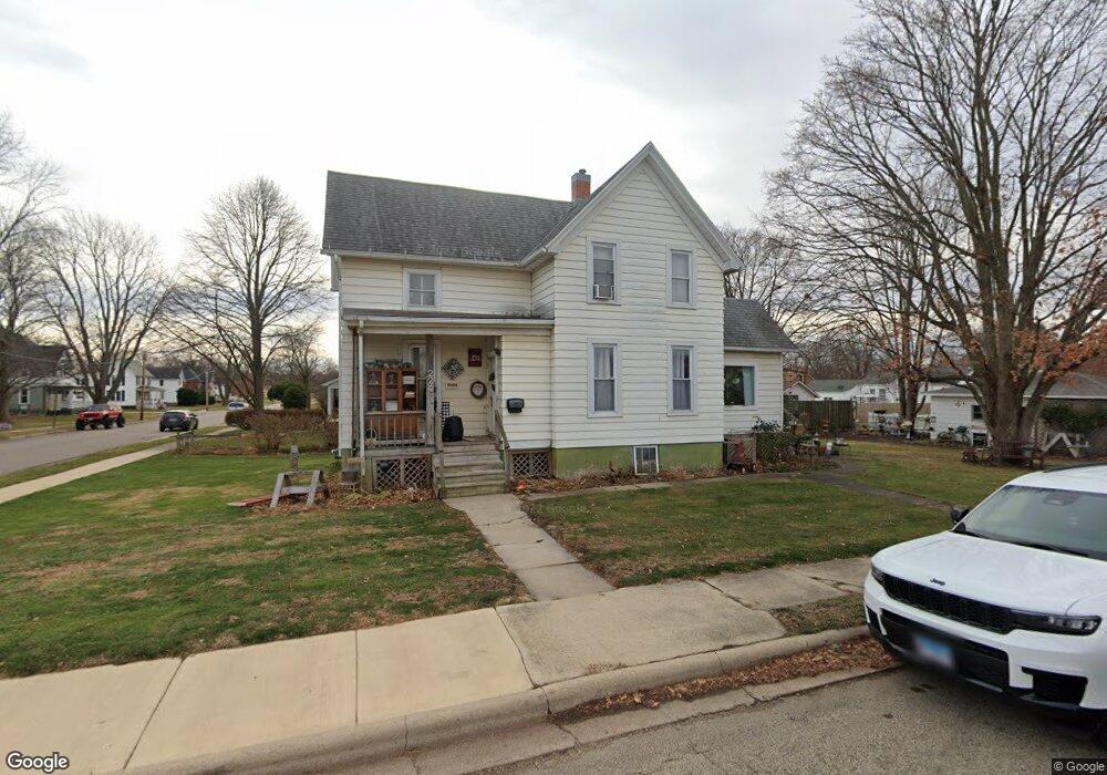
224 E Clark St Princeton, IL 61356
Estimated Value: $121,954 - $166,000
--
Bed
--
Bath
--
Sq Ft
10,280
Sq Ft Lot
About This Home
This home is located at 224 E Clark St, Princeton, IL 61356 and is currently estimated at $143,239. 224 E Clark St is a home located in Bureau County with nearby schools including Jefferson Elementary School, Lincoln Elementary School, and Logan Junior High School.
Ownership History
Date
Name
Owned For
Owner Type
Purchase Details
Closed on
Jul 30, 2019
Sold by
Philippe Richard and Philippe Ruth Ann
Bought by
Rossler Debra Ann
Current Estimated Value
Purchase Details
Closed on
Apr 30, 2019
Sold by
Vetter Larry M and Vetter Grace S
Bought by
J Rayne Llc
Create a Home Valuation Report for This Property
The Home Valuation Report is an in-depth analysis detailing your home's value as well as a comparison with similar homes in the area
Home Values in the Area
Average Home Value in this Area
Purchase History
| Date | Buyer | Sale Price | Title Company |
|---|---|---|---|
| Rossler Debra Ann | -- | None Available | |
| J Rayne Llc | $60,000 | None Available |
Source: Public Records
Tax History Compared to Growth
Tax History
| Year | Tax Paid | Tax Assessment Tax Assessment Total Assessment is a certain percentage of the fair market value that is determined by local assessors to be the total taxable value of land and additions on the property. | Land | Improvement |
|---|---|---|---|---|
| 2024 | $2,302 | $35,750 | $6,137 | $29,613 |
| 2023 | $1,151 | $32,925 | $5,652 | $27,273 |
| 2022 | $2,143 | $30,869 | $5,299 | $25,570 |
| 2021 | $2,067 | $29,221 | $5,016 | $24,205 |
| 2020 | $2,529 | $28,151 | $4,832 | $23,319 |
| 2019 | $2,529 | $27,814 | $4,774 | $23,040 |
| 2018 | $1,938 | $27,338 | $4,692 | $22,646 |
| 2017 | $1,973 | $27,437 | $4,709 | $22,728 |
| 2016 | $1,911 | $26,721 | $4,586 | $22,135 |
| 2015 | -- | $26,254 | $4,506 | $21,748 |
| 2014 | -- | $26,254 | $4,506 | $21,748 |
| 2013 | -- | $26,396 | $4,530 | $21,866 |
Source: Public Records
Map
Nearby Homes
- 919 N Euclid Ave
- 405 N Church St
- 319 N Chestnut St
- 210 N Church St
- 311 W Franklin St
- 0 W Longhaven St Unit MRD12383107
- 20 S Church St
- 725 Independence Dr
- 702 W Hudson St
- 9 S Randolph St
- 305 S Chestnut St
- 443 E Peru St
- 32 S Dallas St
- 8&9 W Century Dr
- 8 & 9 Century Dr
- 810 W Railroad Ave
- 221 W Peru St
- 103 S Plum St
- 525 E Marion St
- 411 W Peru St
- 718 N Chestnut St
- 723 N Chestnut St
- 721 N Chestnut St
- 713 N Chestnut St
- 712 N Chestnut St
- 206 E Clark St
- 715 N Church St
- 706 N Chestnut St
- 711 N Church St
- 703 N Chestnut St
- 703 N Church St
- 726 N Euclid Ave
- 716 N Euclid Ave
- 624 N Chestnut St
- 726 N Church St
- 718 N Church St
- 621 N Chestnut St
- 804 N Church St
- 714 N Church St
- 627 N Church St