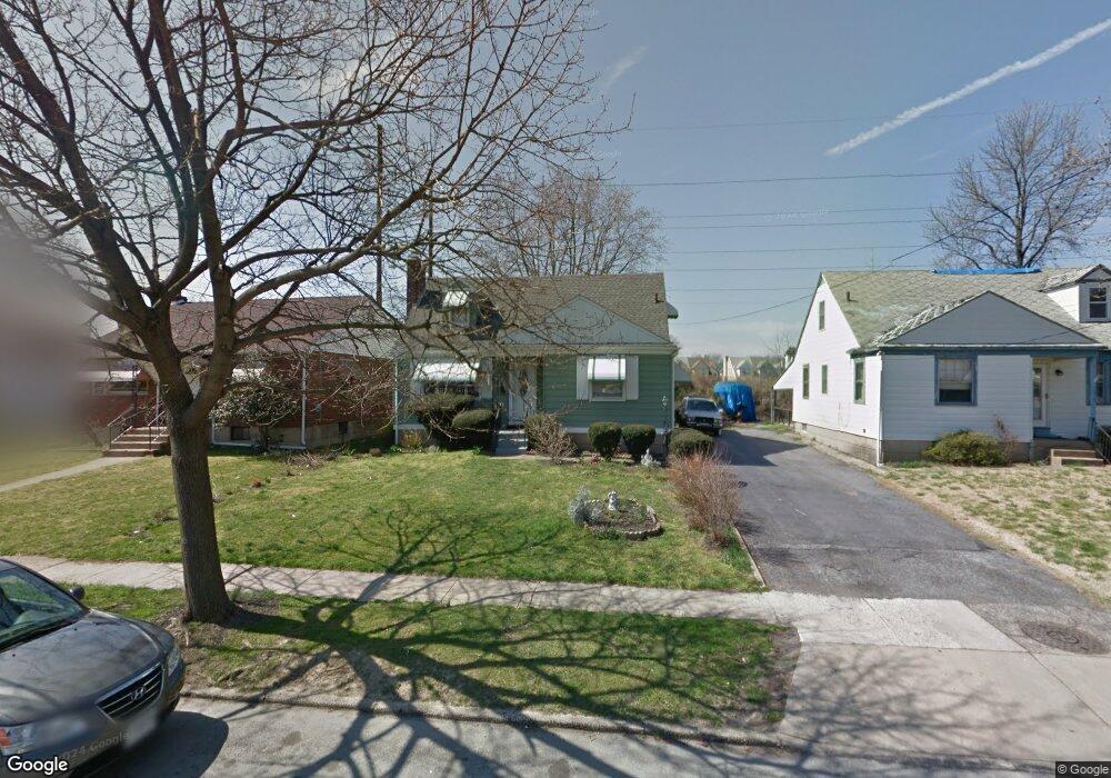
224 Hirst Ave Lansdowne, PA 19050
Estimated Value: $241,000 - $282,350
4
Beds
2
Baths
1,336
Sq Ft
$192/Sq Ft
Est. Value
About This Home
This home is located at 224 Hirst Ave, Lansdowne, PA 19050 and is currently estimated at $256,338, approximately $191 per square foot. 224 Hirst Ave is a home located in Delaware County with nearby schools including East Lansdowne Elementary School, Penn Wood Middle School, and Penn Wood High School - Cypress Street Campus.
Ownership History
Date
Name
Owned For
Owner Type
Purchase Details
Closed on
Apr 28, 2012
Sold by
Gelin Lyonel
Bought by
Geli Lyonel and Gelin Marie C
Current Estimated Value
Purchase Details
Closed on
Mar 28, 2003
Sold by
Sparacio Girolamo and Randazzo Anthony
Bought by
Gelin Lyonel
Home Financials for this Owner
Home Financials are based on the most recent Mortgage that was taken out on this home.
Original Mortgage
$84,333
Outstanding Balance
$36,575
Interest Rate
5.88%
Mortgage Type
FHA
Estimated Equity
$219,763
Create a Home Valuation Report for This Property
The Home Valuation Report is an in-depth analysis detailing your home's value as well as a comparison with similar homes in the area
Home Values in the Area
Average Home Value in this Area
Purchase History
| Date | Buyer | Sale Price | Title Company |
|---|---|---|---|
| Geli Lyonel | -- | None Available | |
| Gelin Lyonel | $85,000 | T A Title Insurance Company |
Source: Public Records
Mortgage History
| Date | Status | Borrower | Loan Amount |
|---|---|---|---|
| Open | Gelin Lyonel | $84,333 |
Source: Public Records
Tax History Compared to Growth
Tax History
| Year | Tax Paid | Tax Assessment Tax Assessment Total Assessment is a certain percentage of the fair market value that is determined by local assessors to be the total taxable value of land and additions on the property. | Land | Improvement |
|---|---|---|---|---|
| 2025 | $6,159 | $144,150 | $51,050 | $93,100 |
| 2024 | $6,159 | $144,150 | $51,050 | $93,100 |
| 2023 | $4,605 | $144,150 | $51,050 | $93,100 |
| 2022 | $5,555 | $144,150 | $51,050 | $93,100 |
| 2021 | $8,283 | $144,150 | $51,050 | $93,100 |
| 2020 | $4,823 | $73,230 | $22,080 | $51,150 |
| 2019 | $4,742 | $73,230 | $22,080 | $51,150 |
| 2018 | $4,680 | $73,230 | $0 | $0 |
| 2017 | $4,441 | $73,230 | $0 | $0 |
| 2016 | $402 | $73,230 | $0 | $0 |
| 2015 | $402 | $73,230 | $0 | $0 |
| 2014 | $402 | $73,230 | $0 | $0 |
Source: Public Records
Map
Nearby Homes
- 319 E Essex Ave
- 317 E Essex Ave
- 315 E Essex Ave
- 226 E Greenwood Ave
- 209 E Greenwood Ave
- 178 N Union Ave
- 230 Wynnewood Ave
- 164 Woodland Ave
- 239 N Maple Ave
- 7229 Clinton Rd
- 608 Pembroke Ave
- 7216 Clinton Rd
- 243 Coverly Rd
- 75 E Stewart Ave
- 291 N Wycombe Ave
- 7247 Guilford Rd
- 88 E Essex Ave
- 669 Long Ln
- 404 Croyden Rd
- 726 Copley Rd
- 212 Hirst Ave
- 228 Hirst Ave
- 208 Hirst Ave
- 230 Hirst Ave
- 234 Hirst Ave
- 204 Hirst Ave
- 202 Hirst Ave
- 227 Hirst Ave
- 347 E Essex Ave
- 229 Hirst Ave
- 236 Hirst Ave
- 345 E Essex Ave
- 231 Hirst Ave
- 343 E Essex Ave
- 233 Hirst Ave
- 341 E Essex Ave
- 237 Hirst Ave
- 339 E Essex Ave
- 339 E Essex Ave Unit Second Floor Apartme
- 339 E Essex Ave Unit 1st Floor Apartment