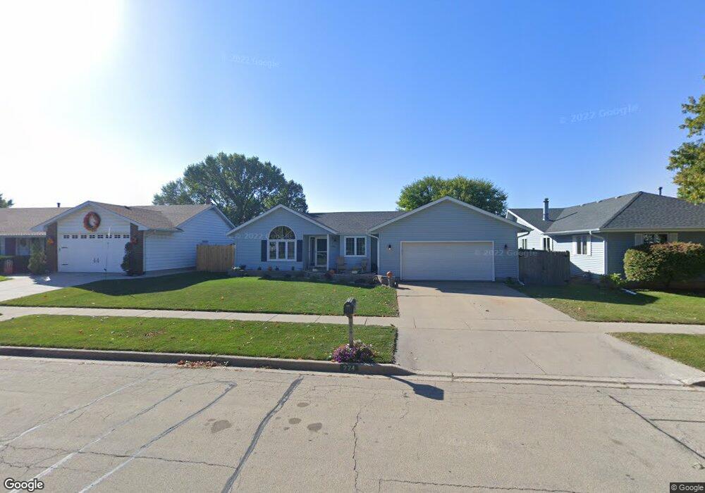
224 N Bridge Rd Dekalb, IL 60115
Estimated Value: $282,721 - $329,000
3
Beds
3
Baths
1,558
Sq Ft
$197/Sq Ft
Est. Value
About This Home
This home is located at 224 N Bridge Rd, Dekalb, IL 60115 and is currently estimated at $306,430, approximately $196 per square foot. 224 N Bridge Rd is a home located in DeKalb County with nearby schools including Lincoln Elementary School, Huntley Middle School, and De Kalb High School.
Ownership History
Date
Name
Owned For
Owner Type
Purchase Details
Closed on
Oct 3, 2025
Sold by
Buehler Rodney A and Orstead Meredith R
Bought by
Buehler & Orstead Living Trust and Buehler
Current Estimated Value
Purchase Details
Closed on
Nov 23, 2010
Sold by
Dymond William C
Bought by
Buehler Rodney A and Orstead Meredith R
Home Financials for this Owner
Home Financials are based on the most recent Mortgage that was taken out on this home.
Original Mortgage
$158,400
Interest Rate
4.17%
Mortgage Type
New Conventional
Create a Home Valuation Report for This Property
The Home Valuation Report is an in-depth analysis detailing your home's value as well as a comparison with similar homes in the area
Home Values in the Area
Average Home Value in this Area
Purchase History
| Date | Buyer | Sale Price | Title Company |
|---|---|---|---|
| Buehler & Orstead Living Trust | -- | None Listed On Document | |
| Buehler Rodney A | $173,000 | -- |
Source: Public Records
Mortgage History
| Date | Status | Borrower | Loan Amount |
|---|---|---|---|
| Previous Owner | Buehler Rodney A | $158,400 |
Source: Public Records
Tax History
| Year | Tax Paid | Tax Assessment Tax Assessment Total Assessment is a certain percentage of the fair market value that is determined by local assessors to be the total taxable value of land and additions on the property. | Land | Improvement |
|---|---|---|---|---|
| 2024 | $5,671 | $75,973 | $10,112 | $65,861 |
| 2023 | $5,505 | $66,242 | $8,817 | $57,425 |
| 2022 | $5,505 | $60,479 | $10,063 | $50,416 |
| 2021 | $5,613 | $56,724 | $9,438 | $47,286 |
| 2020 | $5,729 | $55,820 | $9,288 | $46,532 |
| 2019 | $5,589 | $53,627 | $8,923 | $44,704 |
| 2018 | $5,433 | $51,808 | $8,620 | $43,188 |
| 2017 | $5,456 | $49,801 | $8,286 | $41,515 |
| 2016 | $5,376 | $48,544 | $8,077 | $40,467 |
| 2015 | -- | $45,996 | $7,653 | $38,343 |
| 2014 | -- | $42,903 | $11,073 | $31,830 |
| 2013 | -- | $45,066 | $11,631 | $33,435 |
Source: Public Records
Map
Nearby Homes
- 110 Pooler Ave
- TBD 8.67 Acres Fairview Dr
- 216 Pardridge Place
- 255 Bent Grass Cir
- TBD Peace Rd
- 18.6 Acre Lot Fairview Dr
- TBD Fairview Dr
- 253 Bent Grass Cir
- 1205 S 1st St
- Lot 66 Pebble Beach Ct
- Lot 77 Pebble Beach Ct
- Lot 78 Pebble Beach Ct
- 1212 Bellevue Dr
- 1169 Golf Ct
- 235 Saint Andrews Dr
- 1118 Holmes Place
- 1177 Golf Ct
- 100 Warren Place
- 8750 Gurler Rd
- 910 Dawn Ct
- 228 N Bridge Rd
- 218 N Bridge Rd
- 232 N Bridge Rd
- 214 N Bridge Rd
- 2317 Monticello Dr
- 221 N Bridge Rd
- 236 N Bridge Rd
- 210 N Bridge Rd
- 2324 Monticello Dr
- 215 N Bridge Rd
- 206 N Bridge Rd
- 244 N Bridge Rd
- 2318 Monticello Dr
- 209 N Bridge Rd
- 224 Concord Dr
- 220 Concord Dr
- 2223 Avalon Ct
- 214 Concord Dr
- 2310 Monticello Dr
- 202 N Bridge Rd
Your Personal Tour Guide
Ask me questions while you tour the home.