Estimated Value: $498,000 - $579,363
3
Beds
2
Baths
1,168
Sq Ft
$464/Sq Ft
Est. Value
About This Home
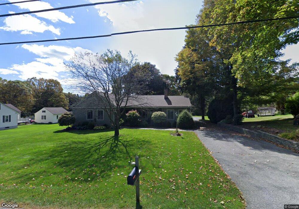
This home is located at 224 New Lenox Rd, Lenox, MA 01240 and is currently estimated at $542,341, approximately $464 per square foot. 224 New Lenox Rd is a home located in Berkshire County with nearby schools including Morris Elementary School, Lenox Memorial High School, and Hillcrest Educational Foundation.
Ownership History
Date
Name
Owned For
Owner Type
Purchase Details
Closed on
Oct 5, 2018
Sold by
Martino Margot P and Martino John A
Bought by
John & Margo Martino Ft
Current Estimated Value
Purchase Details
Closed on
Nov 18, 2005
Sold by
Cancilla Claudette L and Thayer Elaine T
Bought by
Martino John A and Martino Margot P
Purchase Details
Closed on
Jul 23, 2003
Sold by
Molleur Hector
Bought by
Cancilla Claudette L and Thayer Elaine T
Create a Home Valuation Report for This Property
The Home Valuation Report is an in-depth analysis detailing your home's value as well as a comparison with similar homes in the area
Home Values in the Area
Average Home Value in this Area
Purchase History
| Date | Buyer | Sale Price | Title Company |
|---|---|---|---|
| John & Margo Martino Ft | -- | -- | |
| Martino John A | $257,000 | -- | |
| Cancilla Claudette L | -- | -- |
Source: Public Records
Tax History Compared to Growth
Tax History
| Year | Tax Paid | Tax Assessment Tax Assessment Total Assessment is a certain percentage of the fair market value that is determined by local assessors to be the total taxable value of land and additions on the property. | Land | Improvement |
|---|---|---|---|---|
| 2025 | $4,476 | $494,600 | $70,600 | $424,000 |
| 2024 | $4,234 | $466,800 | $66,600 | $400,200 |
| 2023 | $4,106 | $448,200 | $62,800 | $385,400 |
| 2022 | $4,262 | $393,200 | $52,400 | $340,800 |
| 2021 | $4,171 | $358,000 | $48,100 | $309,900 |
| 2020 | $4,035 | $333,500 | $46,700 | $286,800 |
| 2019 | $3,856 | $322,700 | $46,700 | $276,000 |
| 2018 | $3,860 | $312,500 | $45,800 | $266,700 |
| 2017 | $3,772 | $308,900 | $44,900 | $264,000 |
| 2016 | $3,681 | $302,700 | $44,900 | $257,800 |
| 2015 | $3,658 | $296,700 | $51,300 | $245,400 |
Source: Public Records
Map
Nearby Homes
- 813 East St
- 349 New Lenox Rd
- 16 E New Lenox Rd
- 35 Chapman Rd
- 1070 Holmes Rd
- 2 New Lenox Rd
- 2-5 Rolling Hill Build 2 Unit 5 Ln
- 2 Rolling Hills Unit bldg2-4
- 851 E New Lenox Rd
- 1 Pittsfield Rd
- 249 Pittsfield Rd
- 9 October Hill Dr
- 612 E New Lenox Rd
- 57 Palomino Dr
- 36 Joseph Dr
- 31 Eric Dr
- 82 Quirico Dr
- 103 Alpine Trail
- 889 Holmes Rd
- 257 W Mountain Rd
- 228 New Lenox Rd
- 4 Hutchinson Ln
- 216 New Lenox Rd
- 236 New Lenox Rd
- 221 New Lenox Rd
- 3 Hutchinson Ln
- 213 New Lenox Rd
- 6 Hutchinson Ln
- 208 New Lenox Rd
- 5 Hutchinson Ln
- 207 New Lenox Rd
- 8 Hutchinson Ln
- 7 Hutchinson Ln
- 201 New Lenox Rd
- 198 New Lenox Rd
- 10 Hutchinson Ln
- 48 Westminster Rd
- 250 New Lenox Rd
- 9 Hutchinson Ln