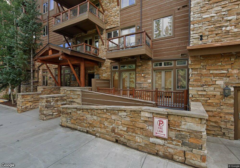
224 Trail Head Trail Dillon, CO 80435
Keystone NeighborhoodEstimated Value: $2,097,531 - $2,303,000
3
Beds
3
Baths
1,733
Sq Ft
$1,251/Sq Ft
Est. Value
About This Home
This home is located at 224 Trail Head Trail, Dillon, CO 80435 and is currently estimated at $2,168,133, approximately $1,251 per square foot. 224 Trail Head Trail is a home located in Summit County with nearby schools including Summit Cove Elementary School, Summit Middle School, and Summit High School.
Ownership History
Date
Name
Owned For
Owner Type
Purchase Details
Closed on
Sep 22, 2017
Sold by
M & R Keystone Llc
Bought by
Blue Spruce Traihead Llc
Current Estimated Value
Purchase Details
Closed on
Nov 10, 2011
Sold by
Mountain Property Holdings Llc
Bought by
M & R Keystone Llc
Purchase Details
Closed on
May 1, 2010
Sold by
Cooper Billy
Bought by
Mountain Property Holdings Llc
Purchase Details
Closed on
Feb 20, 2007
Sold by
Hulsey Paul H
Bought by
Mountain Property Holdings Llc
Create a Home Valuation Report for This Property
The Home Valuation Report is an in-depth analysis detailing your home's value as well as a comparison with similar homes in the area
Home Values in the Area
Average Home Value in this Area
Purchase History
| Date | Buyer | Sale Price | Title Company |
|---|---|---|---|
| Blue Spruce Traihead Llc | $1,265,000 | Stewart Title | |
| M & R Keystone Llc | $770,000 | Land Title Guarantee Company | |
| Mountain Property Holdings Llc | -- | None Available | |
| Mountain Property Holdings Llc | $985,000 | Land Title Guarantee Company |
Source: Public Records
Tax History
| Year | Tax Paid | Tax Assessment Tax Assessment Total Assessment is a certain percentage of the fair market value that is determined by local assessors to be the total taxable value of land and additions on the property. | Land | Improvement |
|---|---|---|---|---|
| 2024 | $7,536 | $143,172 | -- | $143,172 |
| 2023 | $7,536 | $139,487 | $0 | $0 |
| 2022 | $5,196 | $90,941 | $0 | $0 |
| 2021 | $5,241 | $93,558 | $0 | $0 |
| 2020 | $4,829 | $92,086 | $0 | $0 |
| 2019 | $4,763 | $92,086 | $0 | $0 |
| 2018 | $4,084 | $76,507 | $0 | $0 |
| 2017 | $3,735 | $76,507 | $0 | $0 |
| 2016 | $3,744 | $75,540 | $0 | $0 |
| 2015 | $3,627 | $75,540 | $0 | $0 |
| 2014 | $2,963 | $60,927 | $0 | $0 |
| 2013 | -- | $60,927 | $0 | $0 |
Source: Public Records
Map
Nearby Homes
- 628 Montezuma Rd Unit D-1
- 632 Montezuma Rd Unit C-2
- 720 Alhambra Rd Unit 8741
- 280 Trailhead Dr Unit 3053
- 68 Independence Ln
- 58 Hawk Cir Unit 2342
- 90 W Trade Ct
- 225 Alpen Rose Place Unit 8708
- 20 Hunki Dori Ct Unit 2225
- 20 Hunki Dori Ct Unit 2301
- 20 Hunki Dori Ct Unit 2302
- 20 Hunki Dori Ct Unit 2205
- 852 Independence Rd Unit B
- 53 Hunki Dori Ct Unit 8875
- 53 Hunki Dori Ct Unit 8863
- 28 Trappers Crossing Trail Unit 8760
- 75 Hunki Dori Ct Unit W113
- 75 Hunki Dori Ct Unit W401
- 75 Hunki Dori Ct Unit W403
- 75 Hunki Dori Ct Unit W312
- 224 Trail Head Trail
- 224 Trail Head Trail
- 224 Trail Head Trail
- 224 Trail Head Trail
- 224 Trail Head Trail
- 224 Trail Head Trail
- 224 Trail Head Trail
- 224 Trail Head Trail
- 224 Trail Head Trail
- 224 Trail Head Trail
- 224 Trail Head Trail
- 224 Trail Head Trail
- 224 Trail Head Trail
- 224 Trail Head Trail
- 224 Trail Head Trail
- 224 Trail Head Trail
- 224 Trail Head Trail
- 224 Trail Head Trail
- 224 Trail Head Trail
- 224 Trail Head Trail
Your Personal Tour Guide
Ask me questions while you tour the home.