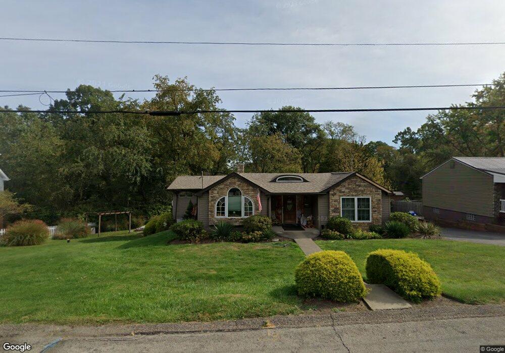
224 Widmer Ave New Kensington, PA 15068
Estimated Value: $71,154 - $189,000
3
Beds
2
Baths
1,033
Sq Ft
$143/Sq Ft
Est. Value
About This Home
This home is located at 224 Widmer Ave, New Kensington, PA 15068 and is currently estimated at $148,039, approximately $143 per square foot. 224 Widmer Ave is a home located in Westmoreland County with nearby schools including Stewart Elementary School, Bon Air El School, and Charles A Huston Middle School.
Ownership History
Date
Name
Owned For
Owner Type
Purchase Details
Closed on
Jul 30, 2008
Sold by
Brown John R
Bought by
Federal National Mortgage Association
Current Estimated Value
Purchase Details
Closed on
Feb 22, 2006
Sold by
Brown John Reed and Brown Deborah A
Bought by
Brown John Reed
Home Financials for this Owner
Home Financials are based on the most recent Mortgage that was taken out on this home.
Original Mortgage
$126,000
Interest Rate
6.16%
Mortgage Type
Stand Alone Refi Refinance Of Original Loan
Purchase Details
Closed on
Sep 26, 2001
Sold by
Brown Barbara I
Bought by
Brown John Reed and Brown Deborah A
Create a Home Valuation Report for This Property
The Home Valuation Report is an in-depth analysis detailing your home's value as well as a comparison with similar homes in the area
Home Values in the Area
Average Home Value in this Area
Purchase History
| Date | Buyer | Sale Price | Title Company |
|---|---|---|---|
| Federal National Mortgage Association | $1,435 | None Available | |
| Brown John Reed | -- | Stewart Title Guaranty Co | |
| Brown John Reed | -- | -- |
Source: Public Records
Mortgage History
| Date | Status | Borrower | Loan Amount |
|---|---|---|---|
| Previous Owner | Brown John Reed | $126,000 |
Source: Public Records
Tax History Compared to Growth
Tax History
| Year | Tax Paid | Tax Assessment Tax Assessment Total Assessment is a certain percentage of the fair market value that is determined by local assessors to be the total taxable value of land and additions on the property. | Land | Improvement |
|---|---|---|---|---|
| 2025 | $2,650 | $15,520 | $3,880 | $11,640 |
| 2024 | $2,549 | $15,520 | $3,880 | $11,640 |
| 2023 | $2,378 | $15,520 | $3,880 | $11,640 |
| 2022 | $2,332 | $15,520 | $3,880 | $11,640 |
| 2021 | $2,277 | $15,520 | $3,880 | $11,640 |
| 2020 | $2,200 | $15,520 | $3,880 | $11,640 |
| 2019 | $2,149 | $15,520 | $3,880 | $11,640 |
| 2018 | $2,110 | $15,520 | $3,880 | $11,640 |
| 2017 | $2,048 | $15,520 | $3,880 | $11,640 |
| 2016 | $1,826 | $14,110 | $3,880 | $10,230 |
| 2015 | $1,826 | $14,110 | $3,880 | $10,230 |
| 2014 | $1,826 | $14,110 | $3,880 | $10,230 |
Source: Public Records
Map
Nearby Homes
- 158 Michigan Ave
- 316 Montana Ave
- 233 Reed St
- 115 Madison Dr
- 143 Macbeth Dr
- 2516 Kentucky Ct
- 324 Paul Dr
- 2647 Norma Dr
- 0 Wayne St
- 181 Edward St
- 2647 Paige St
- 841 Brackenridge Ave
- 1113-1115 Stieren Ave
- 1020 Brackenridge Ave
- 2538 Richdale Dr
- 305 Prospect Cir
- 249 Clarendon Ave
- 408 Craigdell Rd
- 616 E 3rd Ave
- 623 E 3rd Ave