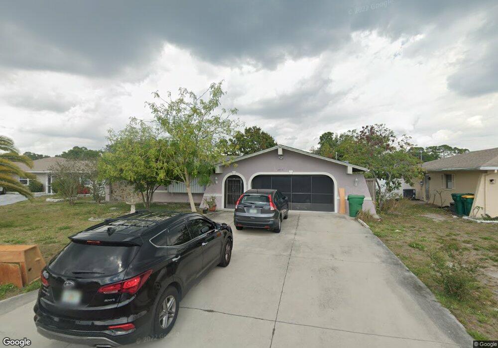
22416 Oceanside Ave Port Charlotte, FL 33952
Estimated Value: $274,000 - $332,000
3
Beds
2
Baths
1,740
Sq Ft
$170/Sq Ft
Est. Value
About This Home
This home is located at 22416 Oceanside Ave, Port Charlotte, FL 33952 and is currently estimated at $295,348, approximately $169 per square foot. 22416 Oceanside Ave is a home located in Charlotte County with nearby schools including Peace River Elementary School, Port Charlotte Middle School, and Charlotte High School.
Ownership History
Date
Name
Owned For
Owner Type
Purchase Details
Closed on
May 15, 2000
Sold by
Victor Armand and Victor Liliane S
Bought by
Victor Armand and Victor Liliane S
Current Estimated Value
Purchase Details
Closed on
Jan 28, 2000
Sold by
Mckay Stephanie L
Bought by
Victor Armand
Home Financials for this Owner
Home Financials are based on the most recent Mortgage that was taken out on this home.
Original Mortgage
$55,650
Interest Rate
8.02%
Create a Home Valuation Report for This Property
The Home Valuation Report is an in-depth analysis detailing your home's value as well as a comparison with similar homes in the area
Home Values in the Area
Average Home Value in this Area
Purchase History
| Date | Buyer | Sale Price | Title Company |
|---|---|---|---|
| Victor Armand | -- | -- | |
| Victor Armand | $79,500 | -- |
Source: Public Records
Mortgage History
| Date | Status | Borrower | Loan Amount |
|---|---|---|---|
| Previous Owner | Victor Armand | $55,650 |
Source: Public Records
Tax History Compared to Growth
Tax History
| Year | Tax Paid | Tax Assessment Tax Assessment Total Assessment is a certain percentage of the fair market value that is determined by local assessors to be the total taxable value of land and additions on the property. | Land | Improvement |
|---|---|---|---|---|
| 2023 | $3,298 | $175,687 | $0 | $0 |
| 2022 | $3,022 | $184,782 | $0 | $0 |
| 2021 | $2,830 | $158,722 | $0 | $0 |
| 2020 | $2,488 | $150,356 | $0 | $0 |
| 2019 | $2,382 | $145,976 | $0 | $0 |
| 2018 | $2,161 | $140,958 | $0 | $0 |
| 2017 | $2,086 | $132,219 | $0 | $0 |
| 2016 | $2,044 | $117,855 | $0 | $0 |
| 2015 | $1,929 | $111,395 | $0 | $0 |
| 2014 | $1,901 | $105,443 | $0 | $0 |
Source: Public Records
Map
Nearby Homes
- 22457 Oceanside Ave
- 22400 Lacombe Ave
- 22480 Oceanside Ave
- 3090 Lockwood St
- 22465 Lewiston Ave
- 22448 Lacombe Ave
- 22337 Olean Blvd
- 22348 Olean Blvd
- 3122 Scranton St
- 22309 Nyack Ave
- 22381 Nyack Ave
- 22271 Morris Ave
- 22357 Nyack Ave
- 2500 Aquilos Ct
- 23108 & 23116 Olean Blvd
- 3295 Brooklyn Ave
- 22516 Ashton Ave
- 22237 Lockport Ave
- 22217 Olean Blvd
- 22220 & 22228 Lockport Ave
- 22424 Oceanside Ave
- 22408 Oceanside Ave
- 22399 New York Ave
- 22407 New York Ave
- 22415 New York Ave
- 22432 Oceanside Ave
- 22400 Oceanside Ave
- 22417 Oceanside Ave
- 22425 Oceanside Ave
- 22409 Oceanside Ave
- 22423 New York Ave
- 22391 New York Ave
- 22441 Oceanside Ave
- 22401 Oceanside Ave
- 22440 Oceanside Ave
- 22392 Oceanside Ave
- 22433 Oceanside Ave
- 0 Oceanside Ave
- 22383 New York Ave
- 22431 New York Ave