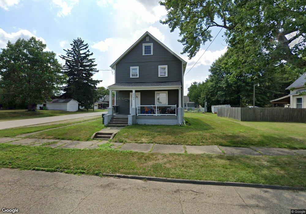
2245 Miller Ave Alliance, OH 44601
Estimated Value: $86,000 - $156,000
3
Beds
2
Baths
1,344
Sq Ft
$90/Sq Ft
Est. Value
About This Home
This home is located at 2245 Miller Ave, Alliance, OH 44601 and is currently estimated at $121,034, approximately $90 per square foot. 2245 Miller Ave is a home located in Stark County with nearby schools including Alliance Elementary School at Rockhill, Alliance Intermediate School at Northside, and Alliance Middle School.
Ownership History
Date
Name
Owned For
Owner Type
Purchase Details
Closed on
Jun 25, 2022
Sold by
John J Admonius Revocable Living Trust
Bought by
Ace & G Properties Ltd
Current Estimated Value
Purchase Details
Closed on
Aug 1, 2006
Sold by
Admonius John J
Bought by
The John J Admonius Revocable Living Tr
Purchase Details
Closed on
Mar 5, 2003
Sold by
Marks Marjorie E and Marks Kenneth R
Bought by
Admonius John E and Admonius Elizabeth A
Purchase Details
Closed on
Nov 23, 1992
Create a Home Valuation Report for This Property
The Home Valuation Report is an in-depth analysis detailing your home's value as well as a comparison with similar homes in the area
Home Values in the Area
Average Home Value in this Area
Purchase History
We collect this data history from publicly available records. To have your information removed, we recommend requesting removal directly through your county’s website.
| Date | Buyer | Sale Price | Title Company |
|---|---|---|---|
| Ace & G Properties Ltd | $50,000 | Sebring Title | |
| The John J Admonius Revocable Living Tr | -- | None Available | |
| Admonius John E | $65,000 | Utc | |
| -- | -- | -- |
Source: Public Records
Tax History
| Year | Tax Paid | Tax Assessment Tax Assessment Total Assessment is a certain percentage of the fair market value that is determined by local assessors to be the total taxable value of land and additions on the property. | Land | Improvement |
|---|---|---|---|---|
| 2025 | -- | $30,250 | $6,270 | $23,980 |
| 2024 | -- | $30,250 | $6,270 | $23,980 |
| 2023 | $721 | $17,510 | $7,950 | $9,560 |
| 2022 | $699 | $16,880 | $7,950 | $8,930 |
| 2021 | $707 | $17,020 | $7,950 | $9,070 |
| 2020 | $652 | $14,670 | $6,900 | $7,770 |
| 2019 | $644 | $14,670 | $6,900 | $7,770 |
| 2018 | $647 | $14,670 | $6,900 | $7,770 |
| 2017 | $3,836 | $12,500 | $5,780 | $6,720 |
| 2016 | $3,053 | $17,400 | $5,780 | $11,620 |
| 2015 | $834 | $17,400 | $5,780 | $11,620 |
| 2014 | $682 | $14,220 | $4,730 | $9,490 |
| 2013 | $272 | $14,220 | $4,730 | $9,490 |
Source: Public Records
Map
Nearby Homes
- 2145 Cherry Ave
- 2135 Cherry Ave
- 2144 Ridgewood Ave
- 2138 Watson Ave
- 2414 Watson Ave
- 2031 Ridgewood Ave
- 2417 S Arch Ave
- 2625 Belleflower Dr
- 2616 Ridgewood Ave
- 231 E Milton St
- 2206 S Linden Ave
- 392 Maplewood Dr
- 421 Linwood Dr
- 2043 S Freedom Ave
- 2464 S Freedom Ave
- 2520 Pleasant Place
- 1539 Parkway Blvd
- 622 Overlook Dr
- 3116 Ridgehill Ave
- 2435 Eastern Ave
- 2233 Miller Ave
- 2305 Miller Ave
- 2250 Clark Ave
- 2221 Miller Ave
- 2230 Clark Ave
- 2306 Clark Ave
- 2248 Miller Ave
- 2220 Clark Ave
- 2315 Miller Ave
- 2234 Miller Ave
- 2205 Miller Ave
- 2306 Miller Ave
- 2220 Miller Ave
- 2324 Clark Ave
- 2208 Clark Ave
- 2325 Miller Ave
- 2208 Miller Ave
- 131 W 23rd St
- 121 W 23rd St
- 2289 Clark Ave
Your Personal Tour Guide
Ask me questions while you tour the home.