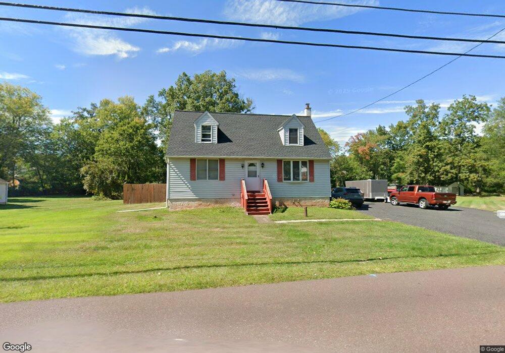
2246 Lenhart Rd Colmar, PA 18915
Estimated Value: $419,000 - $434,000
4
Beds
1
Bath
1,619
Sq Ft
$263/Sq Ft
Est. Value
About This Home
This home is located at 2246 Lenhart Rd, Colmar, PA 18915 and is currently estimated at $426,389, approximately $263 per square foot. 2246 Lenhart Rd is a home located in Montgomery County with nearby schools including A. M. Kulp Elementary School, Penndale Middle School, and North Penn Senior High School.
Ownership History
Date
Name
Owned For
Owner Type
Purchase Details
Closed on
Nov 26, 2014
Sold by
Estate Of Dorothy Hopkins
Bought by
Maybin William J and Diehl Jennifer R
Current Estimated Value
Home Financials for this Owner
Home Financials are based on the most recent Mortgage that was taken out on this home.
Original Mortgage
$209,000
Outstanding Balance
$160,446
Interest Rate
3.98%
Mortgage Type
New Conventional
Estimated Equity
$265,943
Create a Home Valuation Report for This Property
The Home Valuation Report is an in-depth analysis detailing your home's value as well as a comparison with similar homes in the area
Home Values in the Area
Average Home Value in this Area
Purchase History
| Date | Buyer | Sale Price | Title Company |
|---|---|---|---|
| Maybin William J | $220,000 | None Available |
Source: Public Records
Mortgage History
| Date | Status | Borrower | Loan Amount |
|---|---|---|---|
| Open | Maybin William J | $209,000 |
Source: Public Records
Tax History
| Year | Tax Paid | Tax Assessment Tax Assessment Total Assessment is a certain percentage of the fair market value that is determined by local assessors to be the total taxable value of land and additions on the property. | Land | Improvement |
|---|---|---|---|---|
| 2025 | $5,397 | $134,810 | $67,770 | $67,040 |
| 2024 | $5,397 | $134,810 | $67,770 | $67,040 |
| 2023 | $5,166 | $134,810 | $67,770 | $67,040 |
| 2022 | $4,998 | $134,810 | $67,770 | $67,040 |
| 2021 | $4,855 | $134,810 | $67,770 | $67,040 |
| 2020 | $4,741 | $134,810 | $67,770 | $67,040 |
| 2019 | $4,662 | $134,810 | $67,770 | $67,040 |
Source: Public Records
Map
Nearby Homes
- 83 Bethlehem Pike Unit 1306- HAMILTON PLAN
- 83 Bethlehem Pike Unit 1405
- 83 Bethlehem Pike Unit 1111
- 83 Bethlehem Pike Unit 1213 FIRESTONE
- 83 Bethlehem Pike Unit 1106- MADISON PLAN
- 83 Bethlehem Pike Unit 1102- IVY FLOORPLAN
- 83 Bethlehem Pike Unit 1104
- 83 Bethlehem Pike Unit 1109 LEWIS FLOORPLAN
- 5 Fortuna Dr
- 6 Fortuna Dr
- 9 Fortuna Dr
- 8 Fortuna Dr
- 52 Arbor Cir
- 2943 E Walnut St Unit 59
- 2732 Valley Woods Rd
- 202 Country Club Dr
- 4595 County Line Rd
- 210 Pinecrest Ln
- 1148 Independence Way
- 1173 Independence Way
- 2234 Lenhart Rd
- Lot 1 Lenhart Rd
- 2382 Lenhart Rd
- 2339 Lenhart Rd
- 2338 Rebecca Dr
- 2235 Lenhart Rd
- 2233 Lenhart Rd
- 2345 Lenhart Rd
- 2354 Rebecca Dr
- 2330 Rebecca Dr
- 2349 Lenhart Rd
- 2222 Lenhart Rd Unit 1
- 2229 Lenhart Rd
- 2390 Lenhart Rd
- 2215 Lenhart Rd
- 2459 Lenhart Rd
- 2322 Rebecca Dr
- 2362 Rebecca Dr
- 2287 Rebecca Dr
- 2217 Lenhart Rd
Your Personal Tour Guide
Ask me questions while you tour the home.