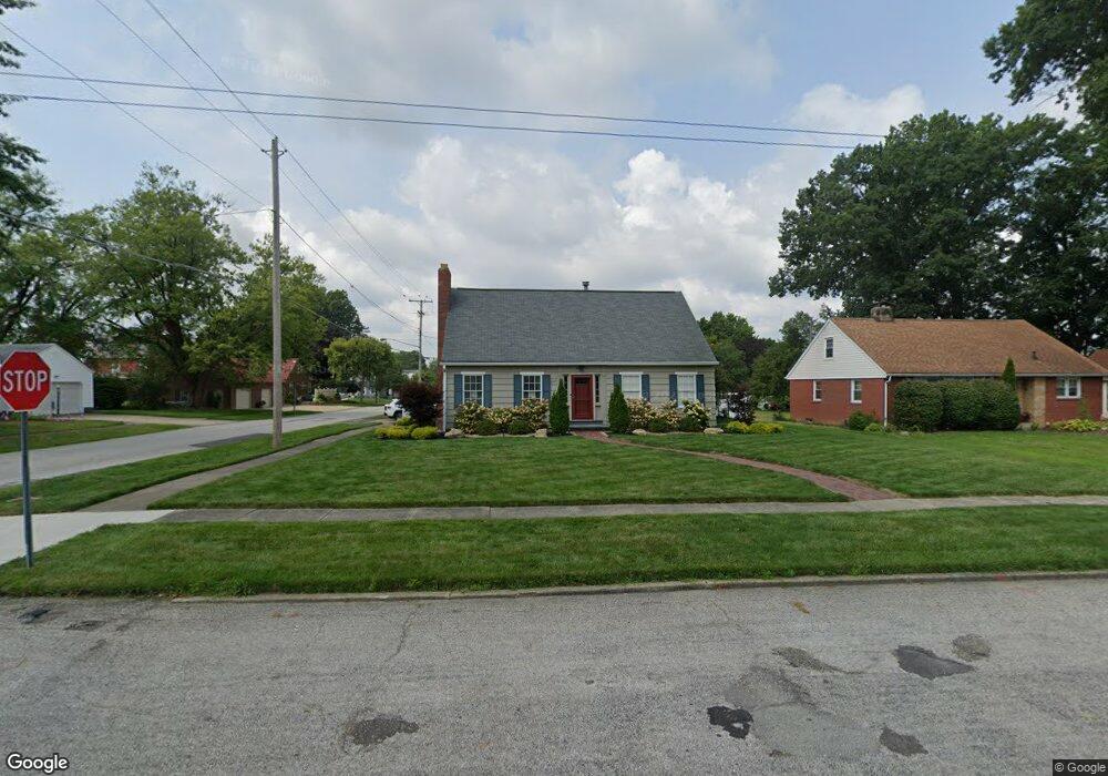
2247 Belleflower Dr Alliance, OH 44601
Estimated Value: $195,000 - $212,244
4
Beds
3
Baths
2,016
Sq Ft
$102/Sq Ft
Est. Value
About This Home
This home is located at 2247 Belleflower Dr, Alliance, OH 44601 and is currently estimated at $204,811, approximately $101 per square foot. 2247 Belleflower Dr is a home located in Stark County with nearby schools including Alliance Elementary School at Rockhill, Alliance Intermediate School at Northside, and Alliance Middle School.
Ownership History
Date
Name
Owned For
Owner Type
Purchase Details
Closed on
Aug 14, 2017
Sold by
Ogline Carol A
Bought by
White Bethany Anne
Current Estimated Value
Home Financials for this Owner
Home Financials are based on the most recent Mortgage that was taken out on this home.
Original Mortgage
$111,200
Outstanding Balance
$92,587
Interest Rate
3.88%
Mortgage Type
New Conventional
Estimated Equity
$112,224
Create a Home Valuation Report for This Property
The Home Valuation Report is an in-depth analysis detailing your home's value as well as a comparison with similar homes in the area
Home Values in the Area
Average Home Value in this Area
Purchase History
| Date | Buyer | Sale Price | Title Company |
|---|---|---|---|
| White Bethany Anne | $139,000 | American Title Associates Ag |
Source: Public Records
Mortgage History
| Date | Status | Borrower | Loan Amount |
|---|---|---|---|
| Open | White Bethany Anne | $111,200 |
Source: Public Records
Tax History Compared to Growth
Tax History
| Year | Tax Paid | Tax Assessment Tax Assessment Total Assessment is a certain percentage of the fair market value that is determined by local assessors to be the total taxable value of land and additions on the property. | Land | Improvement |
|---|---|---|---|---|
| 2025 | -- | $61,290 | $12,320 | $48,970 |
| 2024 | -- | $61,290 | $12,320 | $48,970 |
| 2023 | $1,992 | $49,560 | $9,590 | $39,970 |
| 2022 | $1,002 | $49,560 | $9,590 | $39,970 |
| 2021 | $2,007 | $49,560 | $9,590 | $39,970 |
| 2020 | $1,832 | $42,250 | $8,330 | $33,920 |
| 2019 | $1,806 | $42,250 | $8,330 | $33,920 |
| 2018 | $1,835 | $42,250 | $8,330 | $33,920 |
| 2017 | $1,334 | $39,310 | $7,700 | $31,610 |
| 2016 | $1,345 | $39,310 | $7,700 | $31,610 |
| 2015 | $1,287 | $39,310 | $7,700 | $31,610 |
| 2014 | $1,265 | $35,880 | $7,040 | $28,840 |
| 2013 | $631 | $35,880 | $7,040 | $28,840 |
Source: Public Records
Map
Nearby Homes
- 2705 Shunk Ave
- 884 W College Rd
- 2839 S Rockhill Ave
- 2372 S Union Ave
- 1515 S Rockhill Ave
- 1059 Oakwood Dr
- 2405 Cherry Ave
- 2112 Blenheim Ave
- 3101 Ridgehill Ave
- 2195 Blenheim Ave
- 112 E College St
- 236 E Milton St
- 1321 Parkway Blvd
- 317 E State St
- 2460 S Arch Ave
- 2220 Western Ave
- 1475 Chatauqua Ct
- 1136 Parkway Blvd
- 2408 S Linden Ave
- 390 E College St
- 2235 Belleflower Dr
- 2305 Belleflower Dr
- 2244 Ridgewood Ave
- 2223 Belleflower Dr
- 2234 Ridgewood Ave
- 2306 Ridgewood Ave
- 2248 Belleflower Dr
- 2323 Belleflower Dr
- 2236 Belleflower Dr
- 2320 Ridgewood Ave
- 2208 Ridgewood Ave
- 2161 Belleflower Dr
- 2224 Belleflower Dr
- 2306 Belleflower Dr
- 2330 Ridgewood Ave
- 2365 Belleflower Dr
- 2139 Belleflower Dr
- 2342 Ridgewood Ave
- 2245 Ridgewood Ave
- 2233 Ridgewood Ave