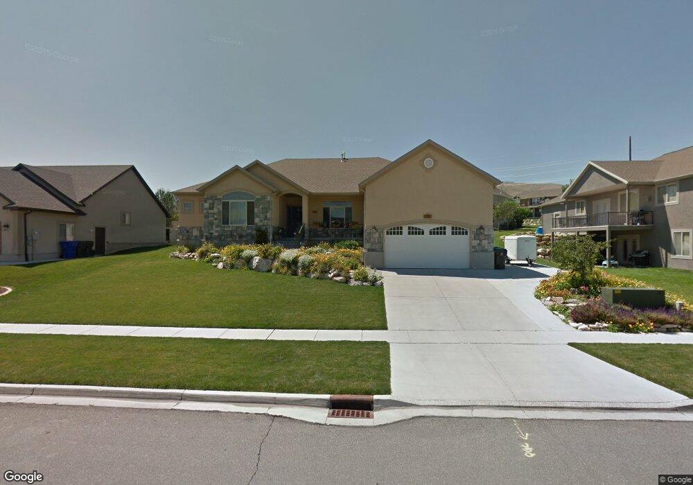
2247 Colt Dr Saratoga Springs, UT 84045
Estimated Value: $648,000 - $700,000
3
Beds
3
Baths
4,253
Sq Ft
$158/Sq Ft
Est. Value
About This Home
This home is located at 2247 Colt Dr, Saratoga Springs, UT 84045 and is currently estimated at $671,425, approximately $157 per square foot. 2247 Colt Dr is a home located in Utah County with nearby schools including Sage Hills Elementary School, Lake Mountain Middle School, and Westlake High School.
Ownership History
Date
Name
Owned For
Owner Type
Purchase Details
Closed on
Apr 18, 2024
Sold by
Farr Kevin K and Farr Tamara D
Bought by
Farr Better Trust and Farr
Current Estimated Value
Purchase Details
Closed on
Aug 24, 2010
Sold by
Deutsche Bank National Trust Company
Bought by
Farr Kevin K and Farr Tamara D
Home Financials for this Owner
Home Financials are based on the most recent Mortgage that was taken out on this home.
Original Mortgage
$158,700
Interest Rate
4.52%
Mortgage Type
New Conventional
Purchase Details
Closed on
Jun 16, 2010
Sold by
Kim Dominique C
Bought by
Deutsche Bank National Trust Company
Purchase Details
Closed on
Feb 28, 2005
Sold by
Peterson Randy
Bought by
Kim Dominique C
Home Financials for this Owner
Home Financials are based on the most recent Mortgage that was taken out on this home.
Original Mortgage
$56,000
Interest Rate
5.7%
Mortgage Type
Stand Alone Second
Purchase Details
Closed on
Aug 13, 2004
Sold by
Land Rock Development Lc
Bought by
Peterson Randy
Create a Home Valuation Report for This Property
The Home Valuation Report is an in-depth analysis detailing your home's value as well as a comparison with similar homes in the area
Home Values in the Area
Average Home Value in this Area
Purchase History
| Date | Buyer | Sale Price | Title Company |
|---|---|---|---|
| Farr Better Trust | -- | None Listed On Document | |
| Farr Kevin K | $242,900 | Provo Land Title Co | |
| Deutsche Bank National Trust Company | $318,287 | Etitle Insurance Agency | |
| Kim Dominique C | -- | Surety Title | |
| Peterson Randy | -- | Title West Title Company |
Source: Public Records
Mortgage History
| Date | Status | Borrower | Loan Amount |
|---|---|---|---|
| Previous Owner | Farr Kevin K | $158,700 | |
| Previous Owner | Kim Dominique C | $56,000 | |
| Previous Owner | Kim Dominique C | $224,000 |
Source: Public Records
Tax History Compared to Growth
Tax History
| Year | Tax Paid | Tax Assessment Tax Assessment Total Assessment is a certain percentage of the fair market value that is determined by local assessors to be the total taxable value of land and additions on the property. | Land | Improvement |
|---|---|---|---|---|
| 2025 | $2,709 | $617,200 | $231,700 | $385,500 |
| 2024 | $2,709 | $325,435 | $0 | $0 |
| 2023 | $2,580 | $333,300 | $0 | $0 |
| 2022 | $2,895 | $364,705 | $0 | $0 |
| 2021 | $2,484 | $467,000 | $130,700 | $336,300 |
| 2020 | $2,384 | $440,100 | $116,700 | $323,400 |
| 2019 | $2,239 | $428,200 | $113,100 | $315,100 |
| 2018 | $2,129 | $384,200 | $106,100 | $278,100 |
| 2017 | $2,108 | $203,500 | $0 | $0 |
| 2016 | $2,018 | $180,840 | $0 | $0 |
| 2015 | $2,127 | $180,840 | $0 | $0 |
| 2014 | $1,989 | $167,145 | $0 | $0 |
Source: Public Records
Map
Nearby Homes
- 2274 S Browning Dr
- 2199 S Morgan Rd
- 2238 S Western Dr
- 2237 S Maverick Rd
- 2226 S Maverick Rd
- 153 W Honeysuckle Dr
- 127 W Honeysuckle Dr Unit 221
- 2387 S Maverick Rd W
- 2559 S Colt Dr
- 2162 S Ruger Dr
- 7323 N Long Dr Unit 607
- 79 E Watson Dr
- 83 E Watson Dr
- 78 Watson Dr
- 89 E Watson Dr
- 103 E Palmer Ln
- 107 E Palmer Ln
- 151 E Cameron Dr
- 111 E Palmer Ln
- 107 E Watson Dr
- 2247 S Colt Dr Unit 523
- 2247 S Colt Dr
- 2242 S Browning Dr
- 2242 S Browning Dr
- 2253 S Colt Dr
- 2253 S Colt Dr
- 2262 Browning Dr
- 2274 Browning Dr
- 2236 Colt Dr
- 2236 S Colt Dr Unit 522
- 2236 S Colt Dr
- 2228 S Colt Dr
- 2228 Colt Dr
- 2252 Colt Dr
- 2252 Colt Dr
- 2263 Colt Dr
- 2263 S Colt Dr Unit 525
- 2263 S Colt Dr
- 2244 S Colt Dr Unit 521
- 2244 Colt Dr