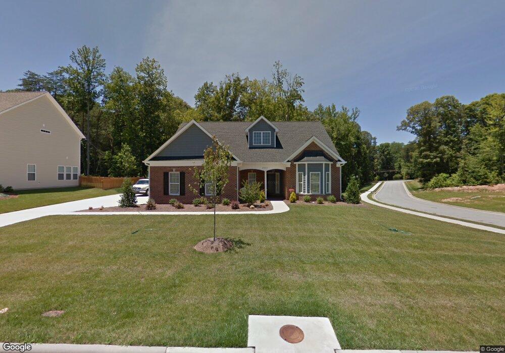
2247 Dunning Ct High Point, NC 27265
Hickswood NeighborhoodEstimated Value: $363,904 - $434,000
3
Beds
3
Baths
2,074
Sq Ft
$191/Sq Ft
Est. Value
About This Home
This home is located at 2247 Dunning Ct, High Point, NC 27265 and is currently estimated at $396,726, approximately $191 per square foot. 2247 Dunning Ct is a home with nearby schools including Florence Elementary School, Welborn Academy of Science & Technology, and T.W. Andrews High School.
Ownership History
Date
Name
Owned For
Owner Type
Purchase Details
Closed on
Dec 8, 2011
Sold by
Investors Land Services L L C
Bought by
Lee Linwood M and Lee Rebecca L
Current Estimated Value
Home Financials for this Owner
Home Financials are based on the most recent Mortgage that was taken out on this home.
Original Mortgage
$266,595
Outstanding Balance
$180,933
Interest Rate
4.15%
Mortgage Type
VA
Estimated Equity
$215,794
Purchase Details
Closed on
Aug 5, 2011
Sold by
Mendenhall Mill Development Llc
Bought by
Investors Land Services L L C
Home Financials for this Owner
Home Financials are based on the most recent Mortgage that was taken out on this home.
Original Mortgage
$210,000
Interest Rate
4.52%
Mortgage Type
Future Advance Clause Open End Mortgage
Create a Home Valuation Report for This Property
The Home Valuation Report is an in-depth analysis detailing your home's value as well as a comparison with similar homes in the area
Home Values in the Area
Average Home Value in this Area
Purchase History
| Date | Buyer | Sale Price | Title Company |
|---|---|---|---|
| Lee Linwood M | $267,000 | None Available | |
| Investors Land Services L L C | $51,000 | None Available |
Source: Public Records
Mortgage History
| Date | Status | Borrower | Loan Amount |
|---|---|---|---|
| Open | Lee Linwood M | $266,595 | |
| Previous Owner | Investors Land Services L L C | $210,000 |
Source: Public Records
Tax History
| Year | Tax Paid | Tax Assessment Tax Assessment Total Assessment is a certain percentage of the fair market value that is determined by local assessors to be the total taxable value of land and additions on the property. | Land | Improvement |
|---|---|---|---|---|
| 2025 | $3,907 | $283,500 | $74,000 | $209,500 |
| 2024 | $3,907 | $283,500 | $74,000 | $209,500 |
| 2023 | $3,907 | $283,500 | $74,000 | $209,500 |
| 2022 | $3,822 | $283,500 | $74,000 | $209,500 |
| 2021 | $3,280 | $238,000 | $50,000 | $188,000 |
| 2020 | $3,280 | $238,000 | $50,000 | $188,000 |
| 2019 | $3,280 | $238,000 | $0 | $0 |
| 2018 | $3,263 | $238,000 | $0 | $0 |
| 2017 | $3,280 | $238,000 | $0 | $0 |
| 2016 | $3,501 | $249,600 | $0 | $0 |
| 2015 | $3,519 | $249,600 | $0 | $0 |
| 2014 | $3,579 | $249,600 | $0 | $0 |
Source: Public Records
Map
Nearby Homes
- 2606 Wexford Place
- 1217 Lakeview Heights Dr
- 2674 Splitbrooke Dr
- 2706 Edenridge Dr
- 2700 Edenridge Dr
- 423 Dogwood Cir
- 113 Red Plum Ln
- 3650 Sunset Hollow Dr
- 2922 Hearthstone Point Dr
- 3630 Sunset Hollow Dr
- 3534 Running Cedar Trail
- 3920 Cloverwood Meadow Ln
- 2511 Copperleaf Ct
- 3946 Cobblestone Bend Dr
- 1227 Greensboro Rd
- 3973 Cobblestone Bend Dr
- 3464 Basalt Ct
- 3871 Eagleston Ct
- 3505 Timbergate Ln
- 3518 Pebblestone Ln
- 2243 Dunning Ct
- 2239 Dunning Ct
- 3906 Stafford Run Ct
- 3867 Stafford Run Ct
- 2235 Dunning Ct
- 3910 Stafford Run Ct
- 2238 Dunning Ct
- 3863 Stafford Run Ct
- 3903 Stafford Run Ct
- 3907 Stafford Run Ct
- 2234 Dunning Ct
- 2231 Dunning Ct
- 3911 Stafford Run Ct
- 1130 Tangle Ln
- 1132 Tangle
- 1128 Tangle Ln
- 2227 Dunning Ct
- 3915 Stafford Run Ct
- 1204 Tangle Ln
- 2226 Dunning Ct
Your Personal Tour Guide
Ask me questions while you tour the home.