Estimated Value: $363,791 - $425,000
3
Beds
2
Baths
1,885
Sq Ft
$208/Sq Ft
Est. Value
About This Home
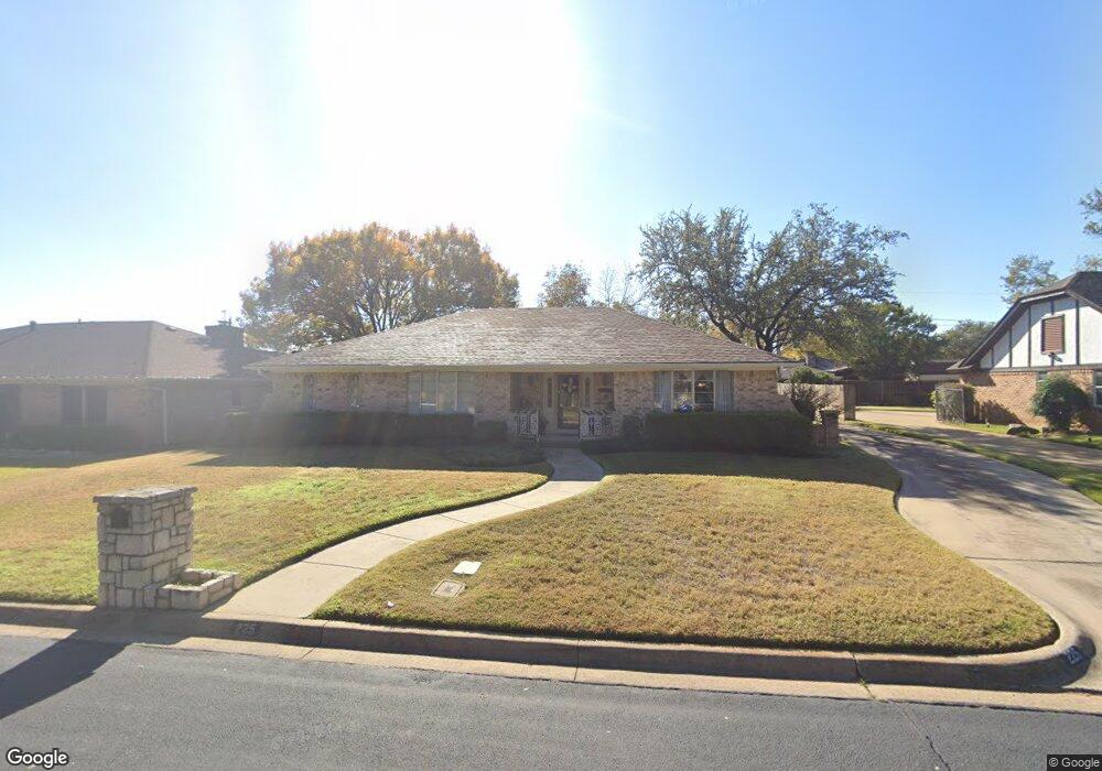
This home is located at 225 Baker Dr, Hurst, TX 76054 and is currently estimated at $392,698, approximately $208 per square foot. 225 Baker Dr is a home located in Tarrant County with nearby schools including Shady Oaks Elementary School, Bedford Junior High School, and L.D. Bell High School.
Ownership History
Date
Name
Owned For
Owner Type
Purchase Details
Closed on
Dec 9, 2016
Sold by
Campbell Billy Ray and Campbell Patsy Ruth
Bought by
Campbell Billy Ray and Campbell Patsy Ruth
Current Estimated Value
Purchase Details
Closed on
May 22, 1998
Sold by
Clark Philip J D and Clark Michelle
Bought by
Campbell Bill and Campbell Patsy
Home Financials for this Owner
Home Financials are based on the most recent Mortgage that was taken out on this home.
Original Mortgage
$96,000
Interest Rate
7.22%
Purchase Details
Closed on
Oct 20, 1995
Sold by
Jackson Richard James
Bought by
Clark Philip J D and Clark Michelle
Home Financials for this Owner
Home Financials are based on the most recent Mortgage that was taken out on this home.
Original Mortgage
$84,800
Interest Rate
7.62%
Create a Home Valuation Report for This Property
The Home Valuation Report is an in-depth analysis detailing your home's value as well as a comparison with similar homes in the area
Home Values in the Area
Average Home Value in this Area
Purchase History
| Date | Buyer | Sale Price | Title Company |
|---|---|---|---|
| Campbell Billy Ray | -- | None Available | |
| Campbell Bill | -- | Alamo Title Co | |
| Clark Philip J D | -- | American Title Company |
Source: Public Records
Mortgage History
| Date | Status | Borrower | Loan Amount |
|---|---|---|---|
| Closed | Campbell Bill | $96,000 | |
| Previous Owner | Clark Philip J D | $84,800 |
Source: Public Records
Tax History
| Year | Tax Paid | Tax Assessment Tax Assessment Total Assessment is a certain percentage of the fair market value that is determined by local assessors to be the total taxable value of land and additions on the property. | Land | Improvement |
|---|---|---|---|---|
| 2025 | $1,128 | $348,303 | $80,000 | $268,303 |
| 2024 | $1,128 | $348,303 | $80,000 | $268,303 |
| 2023 | $6,223 | $361,980 | $55,000 | $306,980 |
| 2022 | $6,501 | $298,033 | $55,000 | $243,033 |
| 2021 | $6,191 | $273,252 | $55,000 | $218,252 |
| 2020 | $5,614 | $257,047 | $55,000 | $202,047 |
| 2019 | $5,192 | $264,454 | $55,000 | $209,454 |
| 2018 | $1,719 | $192,862 | $55,000 | $137,862 |
| 2017 | $4,437 | $214,117 | $40,000 | $174,117 |
| 2016 | $4,033 | $183,915 | $40,000 | $143,915 |
| 2015 | $1,749 | $144,900 | $17,000 | $127,900 |
| 2014 | $1,749 | $144,900 | $17,000 | $127,900 |
Source: Public Records
Map
Nearby Homes
- 201 W Louella Dr
- 201 Hillview Dr
- 440 W Louella Dr
- 137 E Louella Dr
- 413 Baker Dr
- 412 Elisha Dr
- 1720 Acorn Ln
- 404 Mountainview Dr
- 180 Oakhurst Dr
- 600 Circleview Dr N
- 1352 Simpson Dr
- 1761 Cynthia Ln
- 1740 Cynthia Ln
- 421 Cavender Ct
- 1428 Pamela St
- 1756 Cynthia Ln
- 532 Plainview Dr
- 612 Circleview Dr S
- 1348 Norwood Dr
- 1740 Brown Trail
- 229 Baker Dr
- 221 Baker Dr
- 224 Circleview Dr N
- 228 Circleview Dr N
- 220 Circleview Dr N
- 217 Baker Dr
- 233 Baker Dr
- 224 Baker Dr
- 228 Baker Dr
- 220 Baker Dr
- 216 Circleview Dr N
- 232 Circleview Dr N
- 232 Baker Dr
- 213 Baker Dr
- 216 Baker Dr
- 212 Circleview Dr N
- 229 W Louella Dr
- 225 Circleview Dr N
- 233 W Louella Dr
- 225 W Louella Dr
Your Personal Tour Guide
Ask me questions while you tour the home.