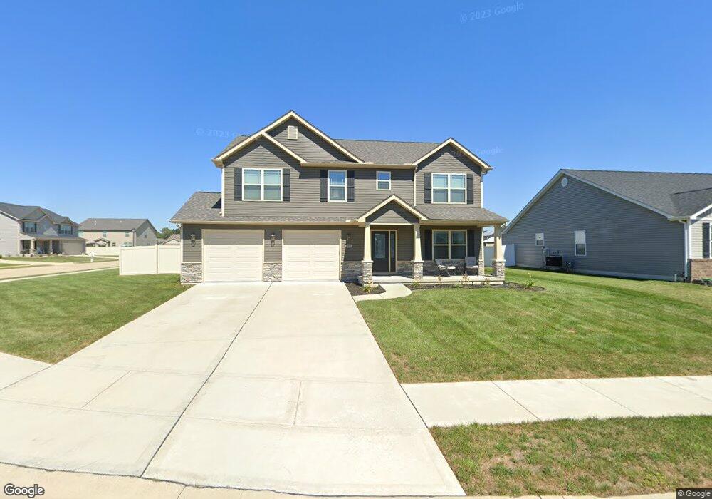
225 Beauregard Dr Shiloh, IL 62221
Estimated Value: $387,000 - $498,134
--
Bed
2
Baths
--
Sq Ft
0.31
Acres
About This Home
This home is located at 225 Beauregard Dr, Shiloh, IL 62221 and is currently estimated at $452,534. 225 Beauregard Dr is a home located in St. Clair County with nearby schools including Mascoutah High School and Zion Lutheran School Belleville.
Ownership History
Date
Name
Owned For
Owner Type
Purchase Details
Closed on
Sep 13, 2019
Sold by
Cnr Inc
Bought by
Mcintosh Mark A and Mcintosh Jennifer M
Current Estimated Value
Home Financials for this Owner
Home Financials are based on the most recent Mortgage that was taken out on this home.
Original Mortgage
$313,868
Outstanding Balance
$273,611
Interest Rate
3.37%
Mortgage Type
VA
Estimated Equity
$178,923
Purchase Details
Closed on
Jun 5, 2019
Sold by
Ttw Llc
Bought by
Cnr Inc
Home Financials for this Owner
Home Financials are based on the most recent Mortgage that was taken out on this home.
Original Mortgage
$246,400
Interest Rate
4.2%
Mortgage Type
Construction
Create a Home Valuation Report for This Property
The Home Valuation Report is an in-depth analysis detailing your home's value as well as a comparison with similar homes in the area
Home Values in the Area
Average Home Value in this Area
Purchase History
| Date | Buyer | Sale Price | Title Company |
|---|---|---|---|
| Mcintosh Mark A | $314,000 | Illiois Title & Escrow | |
| Cnr Inc | $38,000 | Illiois Title & Escrow |
Source: Public Records
Mortgage History
| Date | Status | Borrower | Loan Amount |
|---|---|---|---|
| Open | Mcintosh Mark A | $313,868 | |
| Previous Owner | Cnr Inc | $246,400 |
Source: Public Records
Tax History Compared to Growth
Tax History
| Year | Tax Paid | Tax Assessment Tax Assessment Total Assessment is a certain percentage of the fair market value that is determined by local assessors to be the total taxable value of land and additions on the property. | Land | Improvement |
|---|---|---|---|---|
| 2024 | -- | $134,314 | $24,641 | $109,673 |
| 2023 | -- | $120,221 | $23,916 | $96,305 |
| 2022 | $0 | $111,979 | $22,276 | $89,703 |
| 2021 | $0 | $105,303 | $20,948 | $84,355 |
| 2020 | $0 | $99,385 | $19,771 | $79,614 |
| 2019 | $2,332 | $27,373 | $5,334 | $22,039 |
| 2018 | $31 | $343 | $343 | $0 |
Source: Public Records
Map
Nearby Homes
- 2626 Welsch Dr
- 2709 Cedar Grove Dr
- 2619 Waldon Ln
- 2511 Welsch Dr
- 2601 Cedar Grove Dr
- 2546 London Ln
- 1946 Stingray Ct
- 400 University Dr
- 3233 Scepter Ct
- 204 Bittersweet Ln
- 305 Flagstone Dr
- 2313 College Ave
- 403 Flagstone Dr
- 3231 Stonebridge Dr
- 3217 Millbrook Dr
- 71 Magnolia Dr
- 3021 Carlyle Ave
- xxxx Christine Dr
- 1301 Springfield Dr
- 3416 Lebanon Ave
- 229 Beauregard Dr
- 222 Beauregard Dr
- 226 Beauregard Dr
- 211 Beauregard Dr
- 218 Beauregard Dr
- 233 Beauregard Dr
- 230 Beauregard Dr
- 214 Beauregard Dr
- 210 Beauregard Dr
- 207 Beauregard Dr
- 249 Beauregard Dr
- 2786 London Ln
- 253 Beauregard Dr
- 2778 London Ln
- 2782 London Ln
- 206 Beauregard Dr
- 2790 London Ln
- 242 Beauregard Dr
- 2794 London Ln
- 203 Beauregard Dr