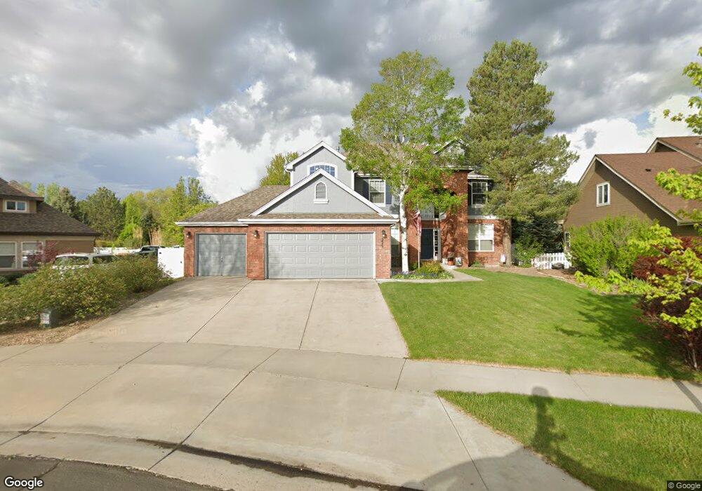
225 Cattail Bay Windsor, CO 80550
Water Valley NeighborhoodEstimated Value: $600,872 - $761,000
4
Beds
5
Baths
2,800
Sq Ft
$242/Sq Ft
Est. Value
About This Home
This home is located at 225 Cattail Bay, Windsor, CO 80550 and is currently estimated at $677,718, approximately $242 per square foot. 225 Cattail Bay is a home located in Weld County with nearby schools including Tozer Elementary School, Mountain View Elementary School, and Windsor Middle School.
Ownership History
Date
Name
Owned For
Owner Type
Purchase Details
Closed on
Sep 4, 1998
Sold by
The Writer Corp
Bought by
Moses Kirk E and Moses Mary E
Current Estimated Value
Home Financials for this Owner
Home Financials are based on the most recent Mortgage that was taken out on this home.
Original Mortgage
$208,400
Outstanding Balance
$44,710
Interest Rate
6.95%
Estimated Equity
$633,008
Purchase Details
Closed on
Jun 26, 1990
Bought by
Trollco Inc
Create a Home Valuation Report for This Property
The Home Valuation Report is an in-depth analysis detailing your home's value as well as a comparison with similar homes in the area
Home Values in the Area
Average Home Value in this Area
Purchase History
| Date | Buyer | Sale Price | Title Company |
|---|---|---|---|
| Moses Kirk E | $261,344 | -- | |
| Trollco Inc | -- | -- |
Source: Public Records
Mortgage History
| Date | Status | Borrower | Loan Amount |
|---|---|---|---|
| Open | Moses Kirk E | $208,400 |
Source: Public Records
Tax History
| Year | Tax Paid | Tax Assessment Tax Assessment Total Assessment is a certain percentage of the fair market value that is determined by local assessors to be the total taxable value of land and additions on the property. | Land | Improvement |
|---|---|---|---|---|
| 2025 | $5,203 | $39,410 | $8,130 | $31,280 |
| 2024 | $5,203 | $39,410 | $8,130 | $31,280 |
| 2023 | $4,770 | $42,120 | $7,100 | $35,020 |
| 2022 | $4,272 | $30,460 | $6,120 | $24,340 |
| 2021 | $4,081 | $31,330 | $6,290 | $25,040 |
| 2020 | $3,767 | $29,300 | $6,290 | $23,010 |
| 2019 | $3,745 | $29,300 | $6,290 | $23,010 |
| 2018 | $3,600 | $27,300 | $5,040 | $22,260 |
| 2017 | $3,686 | $27,300 | $5,040 | $22,260 |
| 2016 | $3,849 | $28,710 | $5,410 | $23,300 |
| 2015 | $3,659 | $28,710 | $5,410 | $23,300 |
| 2014 | $3,092 | $23,190 | $4,380 | $18,810 |
Source: Public Records
Map
Nearby Homes
- 232 Cattail Bay
- 116 Cobble Ct
- 1539 Sandy Ln
- 124 Beacon Way Unit 3
- 149 Sunflower Dr
- 18 Tulip Ct
- 1343 Lake Cir Unit 8B
- 138 Sunflower Dr
- 400 Hemlock Dr
- 1010 3rd St
- 453 Harbor Ct
- 147 Crabapple Dr
- 1002 Teton Ct
- 763 Ponderosa Dr
- 1000 Basin Ct
- 725 Columbine Dr
- 75 Lodgepole Dr
- 713 Apple Ct
- 707 3rd St Unit E5
- 60 Lodgepole Dr
- 227 Cattail Bay
- 223 Cattail Bay
- 230 Mallard Ct
- 229 Cattail Bay
- 230 Cattail Bay
- 231 Mallard Ct
- 221 Cattail Bay
- 234 Mallard Ct
- 228 Wood Duck Ct
- 231 Cattail Bay
- 215 Cattail Bay
- 233 Cattail Bay
- 219 Cattail Bay
- 217 Cattail Bay
- 0 Cattail Bay
- 213 Cattail Bay
- 226 Wood Duck Ct
- 233 Mallard Ct
- 236 Mallard Ct
- 230 Wood Duck Ct
Your Personal Tour Guide
Ask me questions while you tour the home.