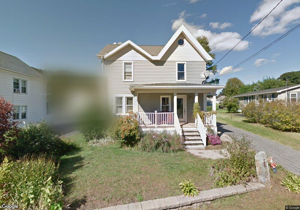
225 Laurel Hill Rd Torrington, CT 06790
Estimated Value: $296,201 - $352,000
3
Beds
2
Baths
1,545
Sq Ft
$205/Sq Ft
Est. Value
About This Home
This home is located at 225 Laurel Hill Rd, Torrington, CT 06790 and is currently estimated at $316,300, approximately $204 per square foot. 225 Laurel Hill Rd is a home located in Litchfield County with nearby schools including Torrington Middle School, Torrington High School, and St. Peter School.
Ownership History
Date
Name
Owned For
Owner Type
Purchase Details
Closed on
Nov 7, 2012
Sold by
Carlson Blair
Bought by
Carlson Jonathan
Current Estimated Value
Purchase Details
Closed on
Dec 17, 2008
Sold by
Schaller Jeremy R and Brandt Karann E
Bought by
Carlson Jonathon and Carlson Blaire
Home Financials for this Owner
Home Financials are based on the most recent Mortgage that was taken out on this home.
Original Mortgage
$152,000
Interest Rate
6.27%
Purchase Details
Closed on
Dec 5, 1997
Sold by
American Bank Of Conn
Bought by
Nolan Charles D
Purchase Details
Closed on
Oct 23, 1990
Sold by
Ponte Antonio
Bought by
Mcmanus Terrance J
Purchase Details
Closed on
May 16, 1990
Sold by
Est Pergola Antionette
Bought by
Pointe Antonio
Create a Home Valuation Report for This Property
The Home Valuation Report is an in-depth analysis detailing your home's value as well as a comparison with similar homes in the area
Home Values in the Area
Average Home Value in this Area
Purchase History
| Date | Buyer | Sale Price | Title Company |
|---|---|---|---|
| Carlson Jonathan | -- | -- | |
| Carlson Jonathon | $190,000 | -- | |
| Nolan Charles D | $60,000 | -- | |
| Mcmanus Terrance J | $8,000 | -- | |
| Pointe Antonio | $85,000 | -- |
Source: Public Records
Mortgage History
| Date | Status | Borrower | Loan Amount |
|---|---|---|---|
| Previous Owner | Pointe Antonio | $145,413 | |
| Previous Owner | Pointe Antonio | $152,000 |
Source: Public Records
Tax History Compared to Growth
Tax History
| Year | Tax Paid | Tax Assessment Tax Assessment Total Assessment is a certain percentage of the fair market value that is determined by local assessors to be the total taxable value of land and additions on the property. | Land | Improvement |
|---|---|---|---|---|
| 2025 | $6,971 | $181,300 | $23,520 | $157,780 |
| 2024 | $4,024 | $83,890 | $23,520 | $60,370 |
| 2023 | $4,023 | $83,890 | $23,520 | $60,370 |
| 2022 | $3,955 | $83,890 | $23,520 | $60,370 |
| 2021 | $3,873 | $83,890 | $23,520 | $60,370 |
| 2020 | $3,873 | $83,890 | $23,520 | $60,370 |
| 2019 | $4,720 | $102,230 | $28,890 | $73,340 |
| 2018 | $4,720 | $102,230 | $28,890 | $73,340 |
| 2017 | $4,677 | $102,230 | $28,890 | $73,340 |
| 2016 | $4,677 | $102,230 | $28,890 | $73,340 |
| 2015 | $4,677 | $102,230 | $28,890 | $73,340 |
| 2014 | $4,022 | $110,740 | $38,240 | $72,500 |
Source: Public Records
Map
Nearby Homes
- 333 Hillside Ave Unit 10
- 91 Harrison Ave
- 184 Harwinton Ave
- 185 Barton St
- 71 Tognalli Dr
- 63 Barbero Dr
- 528 Clearview Ave
- 187 Hillside Ave
- 19 Harwinton Ave
- 505 Harwinton Ave Unit 21
- 505 Harwinton Ave Unit 27
- 119 Tognalli Dr
- 148 Hillside Ave
- 165 Birchwood Dr
- 25 Lipton Place
- 29 Hannah Way
- 291 E Main St
- 172 Pierce St
- 48 Brookside Ave
- 37 Linden St
- 235 Laurel Hill Rd
- 215 Laurel Hill Rd
- 425 Hillside Ave
- 241 Laurel Hill Rd
- 430 Hillside Ave
- 444 Hillside Ave
- 444 Hillside Ave Unit 2
- 415 Hillside Ave
- 424 Hillside Ave
- 238 Laurel Hill Rd
- 251 Laurel Hill Rd
- 216 Laurel Hill Rd
- 197 Laurel Hill Rd
- 105 Birge St
- 405 Hillside Ave
- 254 Laurel Hill Rd
- 412 Hillside Ave
- 194 Laurel Hill Rd
- 26 Harrison Ave