
Seller's Agent in 2026
Paul Gallagher
Gallagher Real Estate
(413) 218-4899
4 in this area
423 Total Sales
Estimated Value: $486,000 - $547,807
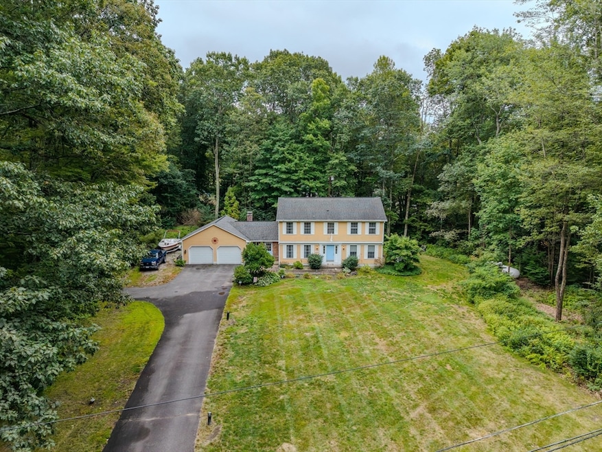
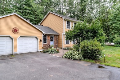
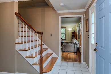
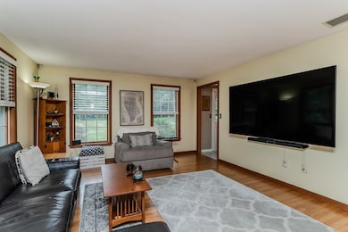
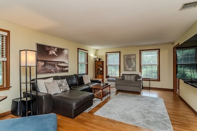
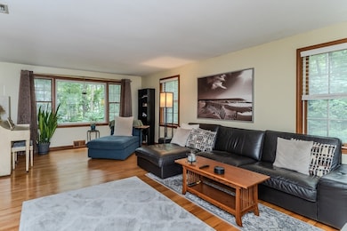
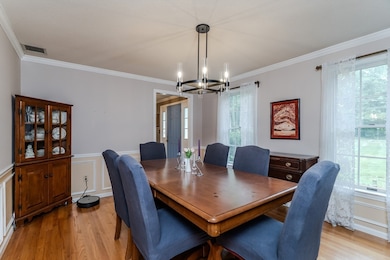
Beautiful 4-bed, 2.5-bath Colonial set on a private 1.51-acre corner lot. Features hardwood floors throughout, including oak flooring in all bedroom. Spacious family room with fireplace opens to a large deck—hot tub and patio set included! Large primary suite with walk-in closet and tiled bath. Partially finished basement with rec room and guest room. Mudroom with laundry (laundry chute!) . Upgrades include a 2-year-old hot water heater, new dehumidifier, French drain system, updated lighting, and a 16kW propane backup generator with a 1,000-gallon (owned) tank. All appliances to remain. A well-maintained home on a classic lot—move-in ready!
We collect this data history from publicly available records. To have your information removed, we recommend requesting removal directly through your county’s website.
| Date | Buyer | Sale Price | Title Company |
|---|---|---|---|
| Engel Robert | $490,000 | -- | |
| Henry Paul | $330,000 | -- | |
| Cooper Steven | $245,000 | -- |
We collect this data history from publicly available records. To have your information removed, we recommend requesting removal directly through your county’s website.
| Date | Status | Borrower | Loan Amount |
|---|---|---|---|
| Previous Owner | Henry Paul | $310,000 | |
| Previous Owner | Cooper Steven | $10,000 | |
| Previous Owner | Cooper Steven | $179,500 | |
| Previous Owner | Cooper Steven | $183,700 |
| Date | Event | Price | List to Sale | Price per Sq Ft |
|---|---|---|---|---|
| 02/27/2026 02/27/26 | Sold | $490,000 | -2.0% | $233 / Sq Ft |
| 01/21/2026 01/21/26 | Pending | -- | -- | -- |
| 01/13/2026 01/13/26 | Price Changed | $499,900 | -5.7% | $238 / Sq Ft |
| 12/19/2025 12/19/25 | Price Changed | $529,900 | -3.5% | $252 / Sq Ft |
| 11/29/2025 11/29/25 | Price Changed | $549,000 | -3.7% | $261 / Sq Ft |
| 10/16/2025 10/16/25 | Price Changed | $569,900 | -2.6% | $271 / Sq Ft |
| 09/17/2025 09/17/25 | Price Changed | $584,900 | -2.5% | $278 / Sq Ft |
| 08/28/2025 08/28/25 | For Sale | $599,900 | -- | $285 / Sq Ft |
| Year | Tax Paid | Tax Assessment Tax Assessment Total Assessment is a certain percentage of the fair market value that is determined by local assessors to be the total taxable value of land and additions on the property. | Land | Improvement |
|---|---|---|---|---|
| 2025 | $9,008 | $503,800 | $96,600 | $407,200 |
| 2024 | $8,945 | $483,500 | $96,600 | $386,900 |
| 2023 | $7,936 | $437,100 | $96,600 | $340,500 |
| 2022 | $7,936 | $387,300 | $96,600 | $290,700 |
| 2021 | $7,850 | $341,900 | $98,400 | $243,500 |
| 2020 | $7,652 | $341,900 | $98,400 | $243,500 |
| 2019 | $7,453 | $341,900 | $98,400 | $243,500 |
| 2018 | $7,415 | $327,500 | $98,400 | $229,100 |
| 2017 | $7,205 | $327,500 | $98,400 | $229,100 |
| 2016 | $7,158 | $331,400 | $108,900 | $222,500 |
| 2015 | $6,920 | $331,400 | $108,900 | $222,500 |
Seller's Agent in 2026
Paul Gallagher
Gallagher Real Estate
(413) 218-4899
4 in this area
423 Total Sales
Seller Co-Listing Agent in 2026
Sully Andujar
Gallagher Real Estate
(413) 523-5664
1 in this area
42 Total Sales
Buyer's Agent in 2026
Luci Giguere
Landmark, REALTORS®
(413) 575-2837
5 in this area
48 Total Sales
Source: MLS Property Information Network (MLS PIN)
MLS Number: 73423120
APN: WILB-007450-000053-003123
Disclaimer: Certain information contained herein is derived from information provided by parties other than Homes.com. All information provided is deemed reliable, but is not guaranteed to be accurate and should be independently verified.
![]() The property listing data and information, or the Images, set forth herein were provided to MLS Property Information Network, Inc. from third party sources, including sellers, lessors and public records, and were compiled by MLS Property Information Network, Inc. The property listing data and information, and the Images, are for the personal, non-commercial use of consumers having a good faith interest in purchasing or leasing listed properties of the type displayed to them and may not be used for any purpose other than to identify prospective properties which such consumers may have a good faith interest in purchasing or leasing. MLS Property Information Network, Inc. and its subscribers disclaim any and all representations and warranties as to the accuracy of the property listing data and information, or as to the accuracy of any of the Images, set forth herein.
The property listing data and information, or the Images, set forth herein were provided to MLS Property Information Network, Inc. from third party sources, including sellers, lessors and public records, and were compiled by MLS Property Information Network, Inc. The property listing data and information, and the Images, are for the personal, non-commercial use of consumers having a good faith interest in purchasing or leasing listed properties of the type displayed to them and may not be used for any purpose other than to identify prospective properties which such consumers may have a good faith interest in purchasing or leasing. MLS Property Information Network, Inc. and its subscribers disclaim any and all representations and warranties as to the accuracy of the property listing data and information, or as to the accuracy of any of the Images, set forth herein.
Ask me questions while you tour the home.