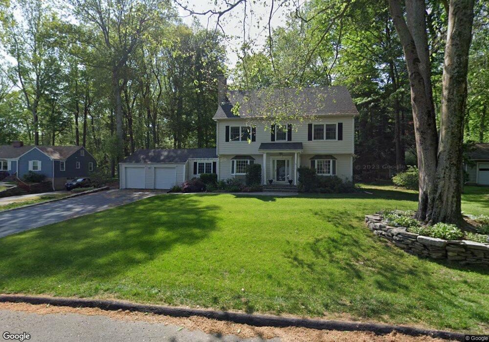
225 Pinewood Trail Trumbull, CT 06611
Daniel Farm District NeighborhoodEstimated Value: $615,000 - $803,000
4
Beds
4
Baths
2,522
Sq Ft
$286/Sq Ft
Est. Value
About This Home
This home is located at 225 Pinewood Trail, Trumbull, CT 06611 and is currently estimated at $720,746, approximately $285 per square foot. 225 Pinewood Trail is a home located in Fairfield County with nearby schools including Booth Hill School, Hillcrest Middle School, and Trumbull High School.
Ownership History
Date
Name
Owned For
Owner Type
Purchase Details
Closed on
Oct 29, 1996
Sold by
Bernard Michael and Bernard Jamie L
Bought by
Conroy John J and Conroy Michele H
Current Estimated Value
Purchase Details
Closed on
Jul 20, 1995
Sold by
Randolph Beth
Bought by
Bernard Michael and Bernard Jamie
Purchase Details
Closed on
Sep 27, 1989
Sold by
Nevins Sheila P
Bought by
Larrabee Beth
Create a Home Valuation Report for This Property
The Home Valuation Report is an in-depth analysis detailing your home's value as well as a comparison with similar homes in the area
Home Values in the Area
Average Home Value in this Area
Purchase History
| Date | Buyer | Sale Price | Title Company |
|---|---|---|---|
| Conroy John J | $192,000 | -- | |
| Bernard Michael | $187,000 | -- | |
| Larrabee Beth | $185,000 | -- |
Source: Public Records
Mortgage History
| Date | Status | Borrower | Loan Amount |
|---|---|---|---|
| Open | Larrabee Beth | $200,000 | |
| Closed | Larrabee Beth | $57,500 |
Source: Public Records
Tax History
| Year | Tax Paid | Tax Assessment Tax Assessment Total Assessment is a certain percentage of the fair market value that is determined by local assessors to be the total taxable value of land and additions on the property. | Land | Improvement |
|---|---|---|---|---|
| 2025 | $11,948 | $323,260 | $147,840 | $175,420 |
| 2024 | $10,144 | $282,590 | $147,840 | $134,750 |
| 2023 | $9,990 | $282,590 | $147,840 | $134,750 |
| 2022 | $9,836 | $282,590 | $147,840 | $134,750 |
| 2021 | $5,001 | $287,280 | $109,760 | $177,520 |
| 2020 | $10,329 | $287,280 | $109,760 | $177,520 |
| 2018 | $5,001 | $287,280 | $109,760 | $177,520 |
| 2017 | $9,911 | $287,280 | $109,760 | $177,520 |
| 2016 | $9,725 | $287,280 | $109,760 | $177,520 |
| 2015 | $9,840 | $292,000 | $109,800 | $182,200 |
| 2014 | $9,630 | $292,000 | $109,800 | $182,200 |
Source: Public Records
Map
Nearby Homes
- 244 Strobel Rd
- 176 Strobel Rd
- 43 Woodmere Dr
- 0 Pinewood Trail
- 2 Doe Hollow Dr
- 38 Macdonald Rd
- 10 Doe Hollow Dr
- 2449 Huntington Turnpike
- 35 Greenfield Dr
- 68 Old Dike Rd
- 0 Lot #4 & Lot #5 W Mischa Rd Unit 24138429
- 7 E Lake Rd
- 10 Foxwood Rd
- 22 Beverly Rd
- 699 Daniels Farm Rd
- 15 Squire Ct
- 15 Coral Dr
- 15 Glenarden Rd
- 311 Isinglass Rd
- 101 Golden Hill St
- 221 Pinewood Trail
- 229 Pinewood Trail
- 22 Bear Den Rd
- 16 Bear Den Rd
- 217 Pinewood Trail
- 224 Pinewood Trail
- 213 Pinewood Trail
- 12 Bear Den Rd
- 216 Pinewood Trail
- 212 Pinewood Trail
- 237 Pinewood Trail
- 28 Hemlock Trail
- 23 Bear Den Rd
- 22 Hemlock Trail
- 8 Hemlock Trail
- 19 Bear Den Rd
- 16 Hemlock Trail
- 207 Pinewood Trail
- 27 Bear Den Rd
- 230 Pinewood Trail
Your Personal Tour Guide
Ask me questions while you tour the home.