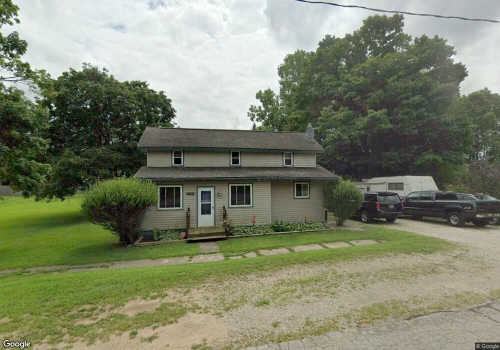
225 Railroad St Addison, MI 49220
Estimated Value: $123,000 - $165,000
3
Beds
1
Bath
1,303
Sq Ft
$107/Sq Ft
Est. Value
About This Home
This home is located at 225 Railroad St, Addison, MI 49220 and is currently estimated at $140,040, approximately $107 per square foot. 225 Railroad St is a home located in Lenawee County with nearby schools including Addison Elementary School, Addison Middle School, and Addison High School.
Ownership History
Date
Name
Owned For
Owner Type
Purchase Details
Closed on
Dec 30, 2014
Sold by
Blackburn Dennis
Bought by
Wellday Diane
Current Estimated Value
Purchase Details
Closed on
Dec 26, 2014
Sold by
Wellday Diane
Bought by
Campbell David L
Purchase Details
Closed on
Oct 15, 2012
Sold by
Keahey Karissa W
Bought by
Blackburn Dennis
Purchase Details
Closed on
Oct 27, 2011
Sold by
Tlc Community Cu
Bought by
Wellday Diane
Purchase Details
Closed on
Sep 29, 2011
Sold by
Isaacson Bernard D
Bought by
Tlc Community Credit Union
Create a Home Valuation Report for This Property
The Home Valuation Report is an in-depth analysis detailing your home's value as well as a comparison with similar homes in the area
Home Values in the Area
Average Home Value in this Area
Purchase History
| Date | Buyer | Sale Price | Title Company |
|---|---|---|---|
| Wellday Diane | -- | American Title Company | |
| Campbell David L | $35,606 | American Title Company | |
| Blackburn Dennis | -- | First American Title Insuran | |
| Wellday Diane | $36,000 | None Available | |
| Tlc Community Credit Union | -- | None Available |
Source: Public Records
Tax History Compared to Growth
Tax History
| Year | Tax Paid | Tax Assessment Tax Assessment Total Assessment is a certain percentage of the fair market value that is determined by local assessors to be the total taxable value of land and additions on the property. | Land | Improvement |
|---|---|---|---|---|
| 2025 | $757 | $51,900 | $0 | $0 |
| 2024 | $586 | $45,700 | $0 | $0 |
| 2023 | -- | $36,800 | $0 | $0 |
| 2022 | $694 | $36,900 | $0 | $0 |
| 2021 | $936 | $31,800 | $0 | $0 |
| 2020 | $915 | $34,000 | $0 | $0 |
| 2019 | $101,300 | $34,000 | $0 | $0 |
| 2018 | $897 | $37,784 | $0 | $0 |
| 2017 | $868 | $38,094 | $0 | $0 |
| 2016 | $1,064 | $37,454 | $0 | $0 |
| 2014 | -- | $54,070 | $0 | $0 |
Source: Public Records
Map
Nearby Homes
- 305 N Steer St
- 135 S Steer St
- 236 S Steer St
- 407 S Comstock St
- 6482 Sorby Hwy
- 5875 U S 127
- 9010 U S 127
- 13820 N Adams Rd
- 0
- VL Manitou Beach Road Proposed
- 0 Manitou Beach Rd Lot B
- 9254 Cherry Point Rd
- 8484 N Rollin Hwy
- 9265 Devils Lake Hwy
- 360 Park St
- 8676 Cherry Point Dr
- 348 Lenawee St
- 1100 Elm Blk St
- 15858 Lelah Ln
- 6000 Devils Lake Hwy
- 219 Railroad St
- 215 Railroad St
- 220 Railroad St
- 222 Saunders St
- 214 N Steer St
- 218 N Steer St
- 226 Saunders St
- 208 Saunders St
- 210 N Steer St
- 236 Saunders St
- 216 Saunders St
- 212 Saunders St
- 200 Railroad St Unit BLK
- 200 Railroad St
- 219 N Steer St
- 300 N Steer St Unit BLK
- 300 N Steer St Unit BLK
- 221 Saunders St
- 1001 U S 127 Unit 17575 US-223
- 1001 U S 127