A
Seller's Agent in 2015
Allan Willcox
Willcox Realty Company
(229) 886-2828
53 Total Sales
Estimated Value: $388,972 - $581,000
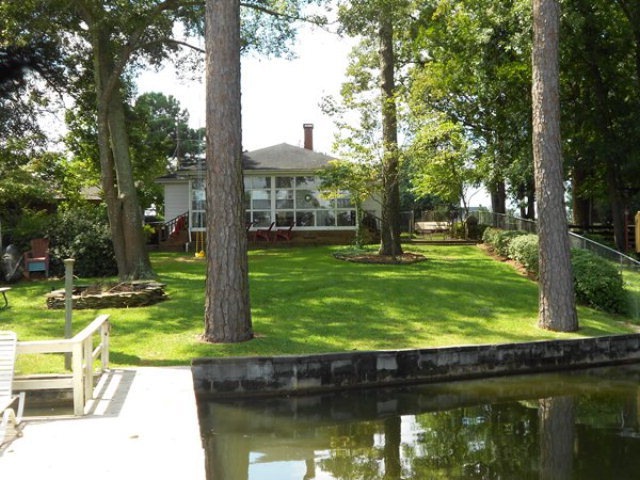
HOME ON LAKE BLACKSHEAR 3 BEDROOM 2 BATH WITH A GUEST HOUSE ( GUEST HOUSE HAS A KITCHEN AREA, BEDROOM / LIVING ROOM, DOCK WITH BOAT SLIP, EXCELLENT LOCATION
Last Agent to Sell the Property
Willcox Realty Company Brokerage Phone: 2294351717 License #201128 Listed on: 05/16/2015
Last Buyer's Agent
Willcox Realty Company Brokerage Phone: 2294351717 License #201128 Listed on: 05/16/2015
| Date | Buyer | Sale Price | Title Company |
|---|---|---|---|
| Denham Michael L | $300,000 | -- | |
| Mcglamry Kelley S | -- | -- | |
| Mcglamry Michael N | $230,000 | -- |
| Date | Status | Borrower | Loan Amount |
|---|---|---|---|
| Open | Denham Michael L | $270,000 | |
| Previous Owner | Mcglamry Michael N | $184,000 |
| Date | Event | Price | List to Sale | Price per Sq Ft |
|---|---|---|---|---|
| 06/25/2015 06/25/15 | Sold | $230,000 | -- | $153 / Sq Ft |
| 05/16/2015 05/16/15 | Pending | -- | -- | -- |
| Year | Tax Paid | Tax Assessment Tax Assessment Total Assessment is a certain percentage of the fair market value that is determined by local assessors to be the total taxable value of land and additions on the property. | Land | Improvement |
|---|---|---|---|---|
| 2024 | $2,752 | $87,101 | $57,696 | $29,405 |
| 2023 | $2,752 | $87,101 | $57,696 | $29,405 |
| 2022 | $2,754 | $87,101 | $57,696 | $29,405 |
| 2021 | $2,731 | $87,101 | $57,696 | $29,405 |
| 2020 | $2,736 | $87,101 | $57,696 | $29,405 |
| 2019 | $2,736 | $87,101 | $57,696 | $29,405 |
| 2018 | $2,392 | $83,501 | $57,696 | $25,805 |
| 2017 | $2,392 | $83,501 | $57,696 | $25,805 |
| 2016 | $2,392 | $83,501 | $57,696 | $25,805 |
| 2015 | $2,508 | $83,501 | $57,696 | $25,805 |
| 2014 | -- | $87,372 | $57,696 | $29,676 |
| 2013 | -- | $87,372 | $57,696 | $29,676 |
| 2012 | -- | $87,372 | $57,696 | $29,676 |
A
Seller's Agent in 2015
Allan Willcox
Willcox Realty Company
(229) 886-2828
53 Total Sales
Source: Albany Board of REALTORS®
MLS Number: 132213
APN: LK060-015-000
