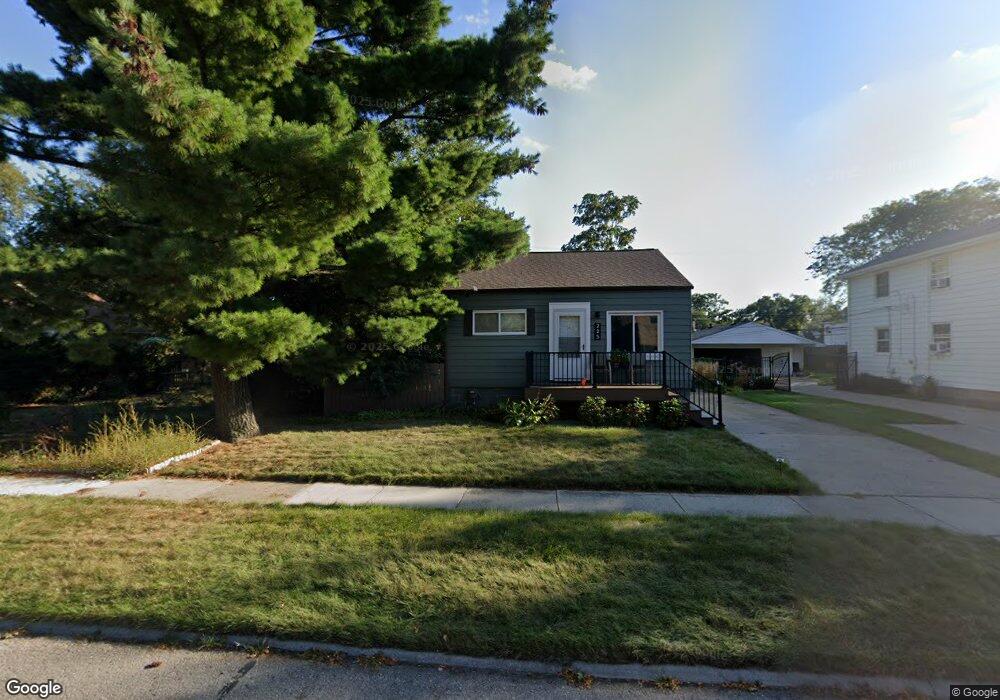
225 W Hazelhurst St Ferndale, MI 48220
Estimated Value: $239,523 - $300,000
3
Beds
1
Bath
1,118
Sq Ft
$241/Sq Ft
Est. Value
About This Home
This home is located at 225 W Hazelhurst St, Ferndale, MI 48220 and is currently estimated at $269,381, approximately $240 per square foot. 225 W Hazelhurst St is a home located in Oakland County with nearby schools including Ferndale Lower Elementary Campus, Ferndale Upper Elementary Campus, and Ferndale Middle School.
Ownership History
Date
Name
Owned For
Owner Type
Purchase Details
Closed on
Feb 15, 2018
Sold by
Tomlinson Lyle James and Tomlinson Kim M
Bought by
Tomlenson Properties Llc
Current Estimated Value
Purchase Details
Closed on
May 15, 2009
Sold by
Us Bank National Association
Bought by
Tomlinson Lyle J and Tomlinson Kim M
Purchase Details
Closed on
Sep 12, 2008
Sold by
Greenpoint Mortgage Corporation
Bought by
Us Bank National Association and Mlmi 2005-A6
Purchase Details
Closed on
Aug 5, 2008
Sold by
Holman David P
Bought by
Greenpoint Mortgage Corp
Create a Home Valuation Report for This Property
The Home Valuation Report is an in-depth analysis detailing your home's value as well as a comparison with similar homes in the area
Home Values in the Area
Average Home Value in this Area
Purchase History
| Date | Buyer | Sale Price | Title Company |
|---|---|---|---|
| Tomlenson Properties Llc | -- | None Available | |
| Tomlinson Lyle J | $32,000 | Attorneys Title Agency Llc | |
| Us Bank National Association | -- | E Title | |
| Greenpoint Mortgage Corp | $158,649 | None Available |
Source: Public Records
Tax History Compared to Growth
Tax History
| Year | Tax Paid | Tax Assessment Tax Assessment Total Assessment is a certain percentage of the fair market value that is determined by local assessors to be the total taxable value of land and additions on the property. | Land | Improvement |
|---|---|---|---|---|
| 2024 | $3,076 | $121,470 | $0 | $0 |
| 2023 | $2,970 | $116,550 | $0 | $0 |
| 2022 | $2,942 | $106,300 | $0 | $0 |
| 2021 | $2,933 | $95,040 | $0 | $0 |
| 2020 | $2,809 | $89,420 | $0 | $0 |
| 2019 | $2,829 | $79,670 | $0 | $0 |
| 2018 | $2,821 | $69,180 | $0 | $0 |
| 2017 | $2,780 | $67,090 | $0 | $0 |
| 2016 | $2,745 | $54,730 | $0 | $0 |
| 2015 | -- | $46,740 | $0 | $0 |
| 2014 | -- | $39,870 | $0 | $0 |
| 2011 | -- | $43,190 | $0 | $0 |
Source: Public Records
Map
Nearby Homes
- 918 Saint Louis St
- 271 College St
- 855 Allen St
- 324 Albany St
- 204 Wordsworth St
- 364 E Hazelhurst St
- 341 E Saratoga St
- 378 Fielding St
- 366 E Marshall St
- 211 Silman St
- 221 Silman St
- 300 Wordsworth St
- 287 Fielding St
- 404 Laprairie St
- 415 Laprairie St
- 211 E 9 Mile Rd Unit 311
- 242 W Webster St
- 535 E Saratoga St
- 571 W Saratoga St
- 559 Gardendale St
- 225 W Hazelhurst St
- 237 W Hazelhurst St
- 247 W Hazelhurst St
- 215 W Hazelhurst St Unit Bldg-Unit
- 215 W Hazelhurst St
- 215 W Hazelhurst St
- 207 W Hazelhurst St
- 257 W Hazelhurst St
- 222 W Marshall St
- 222 W Marshall St
- 210 W Marshall St
- 210 W Marshall St
- 258 W Marshall St
- 258 W Marshall St Unit Lower
- 265 W Hazelhurst St
- 265 W Hazelhurst St
- 198 W Marshall St Unit 3
- 198 W Marshall St Unit 6
- 22111 Woodward Ave
- 277 W Hazelhurst St