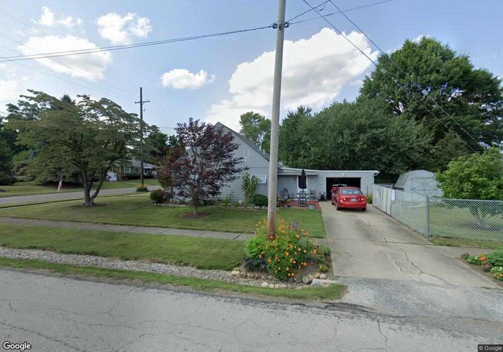
2250 Clark Ave Alliance, OH 44601
Estimated Value: $126,000 - $163,000
3
Beds
2
Baths
1,152
Sq Ft
$122/Sq Ft
Est. Value
About This Home
This home is located at 2250 Clark Ave, Alliance, OH 44601 and is currently estimated at $140,103, approximately $121 per square foot. 2250 Clark Ave is a home located in Stark County with nearby schools including Alliance Elementary School at Rockhill, Alliance Intermediate School at Northside, and Alliance Middle School.
Ownership History
Date
Name
Owned For
Owner Type
Purchase Details
Closed on
Dec 29, 2006
Sold by
Admonius John J and Admonius Marlene A
Bought by
Admonius Albert L and Admonius Theresa
Current Estimated Value
Purchase Details
Closed on
Aug 10, 2006
Sold by
Admonius John
Bought by
The John J Admonius Revocable Living Tr
Purchase Details
Closed on
Apr 28, 2004
Sold by
Copeland Norma V
Bought by
Admonius John
Purchase Details
Closed on
Sep 26, 2002
Sold by
Copeland William K and Copeland Norma V
Bought by
Copeland William K and Copeland Norma
Create a Home Valuation Report for This Property
The Home Valuation Report is an in-depth analysis detailing your home's value as well as a comparison with similar homes in the area
Home Values in the Area
Average Home Value in this Area
Purchase History
| Date | Buyer | Sale Price | Title Company |
|---|---|---|---|
| Admonius Albert L | $68,500 | Attorney | |
| The John J Admonius Revocable Living Tr | -- | None Available | |
| Admonius John | $75,000 | Union Title Co | |
| Copeland William K | -- | -- |
Source: Public Records
Tax History Compared to Growth
Tax History
| Year | Tax Paid | Tax Assessment Tax Assessment Total Assessment is a certain percentage of the fair market value that is determined by local assessors to be the total taxable value of land and additions on the property. | Land | Improvement |
|---|---|---|---|---|
| 2025 | -- | $31,470 | $7,460 | $24,010 |
| 2024 | -- | $31,470 | $7,460 | $24,010 |
| 2023 | $1,220 | $30,350 | $9,420 | $20,930 |
| 2022 | $614 | $30,350 | $9,420 | $20,930 |
| 2021 | $1,229 | $30,350 | $9,420 | $20,930 |
| 2020 | $1,111 | $25,620 | $8,190 | $17,430 |
| 2019 | $1,095 | $25,620 | $8,190 | $17,430 |
| 2018 | $1,100 | $25,620 | $8,190 | $17,430 |
| 2017 | $1,008 | $23,100 | $6,860 | $16,240 |
| 2016 | $899 | $20,440 | $6,860 | $13,580 |
| 2015 | $907 | $20,440 | $6,860 | $13,580 |
| 2014 | $779 | $16,700 | $5,600 | $11,100 |
| 2013 | $388 | $16,700 | $5,600 | $11,100 |
Source: Public Records
Map
Nearby Homes
- 236 E Milton St
- 2460 S Arch Ave
- 317 E State St
- 112 E College St
- 2408 S Linden Ave
- 2839 S Rockhill Ave
- 884 W College Rd
- 2218 S Freedom Ave
- 1515 S Rockhill Ave
- 390 E College St
- 1475 Chatauqua Ct
- 1846 S Freedom Ave
- 2376 S Seneca Ave
- 555 E Milton St
- 3101 Ridgehill Ave
- 1059 Oakwood Dr
- 1437 S Linden Ave
- 1321 Parkway Blvd
- 853 Fairway Dr
- 2112 Blenheim Ave
- 2230 Clark Ave
- 2306 Clark Ave
- 2245 Miller Ave
- 2220 Clark Ave
- 2233 Miller Ave
- 2305 Miller Ave
- 2221 Miller Ave
- 2229 Clark Ave
- 2208 Clark Ave
- 2324 Clark Ave
- 2315 Miller Ave
- 260 W 23rd St
- 2205 Miller Ave
- 2219 Clark Ave
- 2205 Clark Ave
- 270 W 23rd St
- 285 W 23rd St
- 2325 Miller Ave
- 2248 Miller Ave
- 2148 Clark Ave