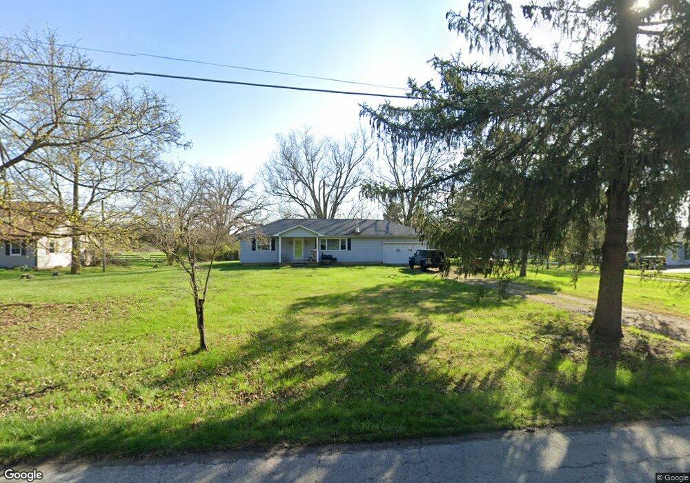
2255 Olmstead Rd West Jefferson, OH 43162
Estimated Value: $252,566 - $315,000
2
Beds
1
Bath
1,144
Sq Ft
$257/Sq Ft
Est. Value
About This Home
This home is located at 2255 Olmstead Rd, West Jefferson, OH 43162 and is currently estimated at $293,892, approximately $256 per square foot. 2255 Olmstead Rd is a home located in Madison County with nearby schools including Norwood Elementary School, West Jefferson Middle School, and West Jefferson High School.
Ownership History
Date
Name
Owned For
Owner Type
Purchase Details
Closed on
Apr 29, 2019
Sold by
Durban Alevia J and The Smith Property Mangement T
Bought by
Smith Beryl E
Current Estimated Value
Purchase Details
Closed on
Dec 19, 2013
Sold by
Smith Carl A and Smith Dorothy M
Bought by
Durban Alevia J and The Smith Property Management Trust
Purchase Details
Closed on
Jul 18, 2008
Sold by
Treadway Carol J and Treadway James R
Bought by
Smith Carl A and Smith Dorothy Mae
Create a Home Valuation Report for This Property
The Home Valuation Report is an in-depth analysis detailing your home's value as well as a comparison with similar homes in the area
Home Values in the Area
Average Home Value in this Area
Purchase History
| Date | Buyer | Sale Price | Title Company |
|---|---|---|---|
| Smith Beryl E | -- | None Available | |
| Durban Alevia J | -- | None Available | |
| Smith Carl A | $138,500 | Attorney |
Source: Public Records
Tax History Compared to Growth
Tax History
| Year | Tax Paid | Tax Assessment Tax Assessment Total Assessment is a certain percentage of the fair market value that is determined by local assessors to be the total taxable value of land and additions on the property. | Land | Improvement |
|---|---|---|---|---|
| 2024 | $3,351 | $75,770 | $16,840 | $58,930 |
| 2023 | $3,351 | $75,770 | $16,840 | $58,930 |
| 2022 | $2,733 | $57,520 | $14,000 | $43,520 |
| 2021 | $2,744 | $57,520 | $14,000 | $43,520 |
| 2020 | $2,793 | $57,520 | $14,000 | $43,520 |
| 2019 | $2,350 | $47,680 | $13,650 | $34,030 |
| 2018 | $2,185 | $47,680 | $13,650 | $34,030 |
| 2017 | $2,189 | $47,680 | $13,650 | $34,030 |
| 2016 | $1,979 | $42,250 | $13,650 | $28,600 |
| 2015 | $2,064 | $42,250 | $13,650 | $28,600 |
| 2014 | $2,064 | $42,250 | $13,650 | $28,600 |
| 2013 | -- | $45,790 | $13,650 | $32,140 |
Source: Public Records
Map
Nearby Homes
- 125 Dogwood Ct
- 0 W Jeff Kiousville Rd Unit 225000725
- 700 Shawn Dr Unit 88
- 1890 Wilson Rd SE
- 304 Middle Dr
- 63 Jones St
- 622 Brookdale Dr
- 3370 Seaman Rd
- 2793 Ohio St
- 2731 Sandusky St
- 10763 Southwood Rd
- 4550 Lc Opossum Rd
- 360 State Route 142 NE
- 1000 W Main St Unit 120
- 5930 Lilly Chapel Opossum Run Rd
- 5765 Lilly Chapel Opossum Run Rd
- 8629 Canyon Cove Rd
- 8548 Canyon Cove Rd
- 8482 Dover Crest Ct
- 3388 Harrisburg Georgesville Rd
- 2195 Olmstead Rd
- 2275 Olmstead Rd
- 2265 Olmstead Rd
- 2264 Olmstead Rd
- 2165 Olmstead Rd
- 2150 Olmstead Rd
- 2345 Olmstead Rd
- 2365 Olmstead Rd
- 2295 Olmstead Rd
- 2380 Olmstead Rd
- 2115 Olmstead Rd
- 2377 Olmstead Rd
- 2425 Olmstead Rd
- 9333 Roberts Rd SE
- 2075 Olmstead Rd
- 2435 Olmstead Rd
- 9381 Roberts Rd SE
- 9597 Roberts Rd SE
- 9419 Roberts Rd SE
- 9250 Roberts Rd SE