


2255 Red River West Grove Rd Arcanum, OH 45304
Estimated payment $1,622/month
Highlights
- Mud Room
- Porch
- Window Unit Cooling System
- No HOA
- 2 Car Attached Garage
- Bathroom on Main Level
About This Home
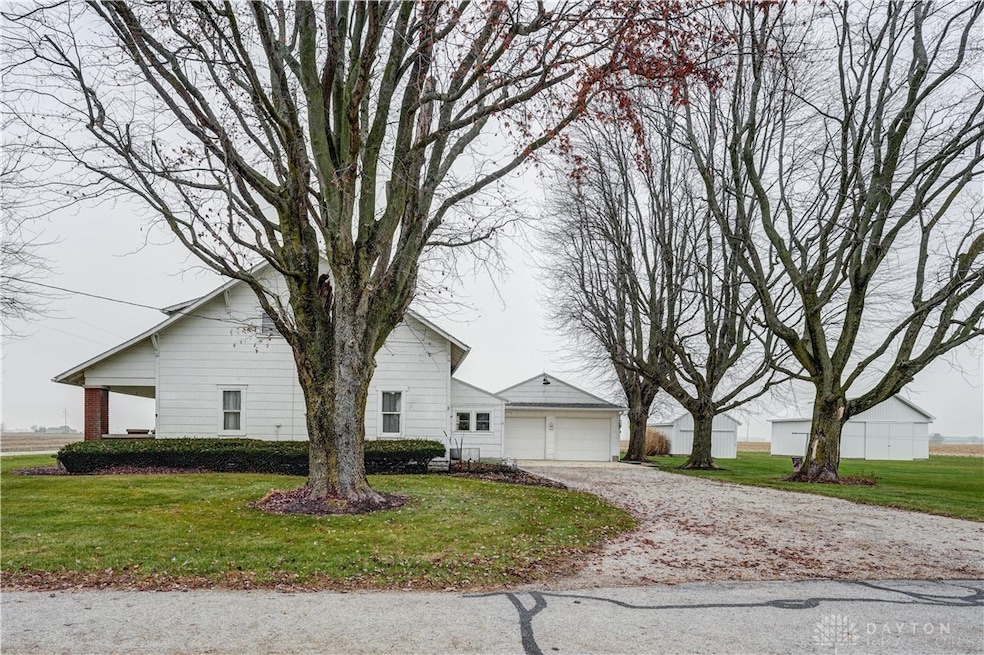
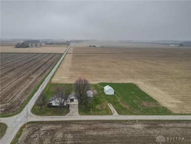
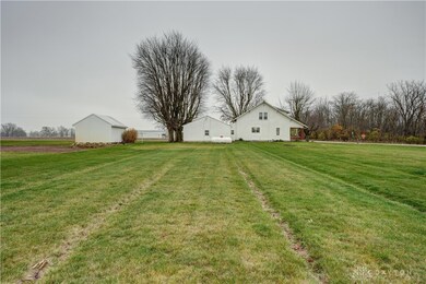
Your dream of peaceful country living starts now at 2255 Red River West Grove Rd! This stunning, remodeled farmhouse sits on nearly 2 acres of open countryside, offering the perfect blend of charm, comfort, and modern convenience. From the moment you arrive, you'll feel the warmth and inviting character of this beautifully updated home.
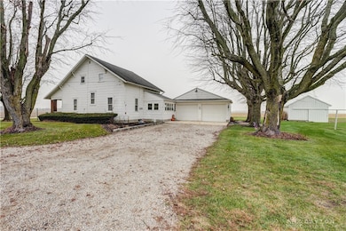
Step inside to find gorgeous original hardwood floors paired with thoughtful upgrades throughout, including new LVP flooring, 13 brand-new windows, newer water heater and softener, updated roofing on the garage and mudroom, and a freshly poured concrete pad leading to the attached 2-car garage. This truly is move-in ready living at its finest!
Outside, the possibilities are endless with two metal-sided barns (22x30 and 14x16)—both with concrete floors—ideal for hobbyists, storage, small animals, or your next big project. All major appliances stay, making the transition into your new home effortless. Located in the Franklin Monroe School District and just 2 miles from the school
A country retreat like this doesn’t come along often—don’t miss your chance to claim this beautifully restored farmhouse and make it your own!
Listing Agent
DJ Rose Realty Brokerage Phone: (937) 547-3077 License #2016003654 Listed on: 11/19/2025
Home Details
Home Type
- Single Family
Est. Annual Taxes
- $1,400
Year Built
- 1926
Parking
- 2 Car Attached Garage
Home Design
- Shingle Siding
- Asbestos
Interior Spaces
- 1,612 Sq Ft Home
- 2-Story Property
- Ceiling Fan
- Vinyl Clad Windows
- Mud Room
- Unfinished Basement
- Partial Basement
- Range
Bedrooms and Bathrooms
- 3 Bedrooms
- Bathroom on Main Level
Laundry
- Dryer
- Washer
Utilities
- Window Unit Cooling System
- Forced Air Heating System
- Heating System Uses Propane
- Baseboard Heating
- Well
- Electric Water Heater
- Water Softener
- Septic Tank
- Septic System
Additional Features
- Porch
- 1.96 Acre Lot
Community Details
- No Home Owners Association
Listing and Financial Details
- Assessor Parcel Number K39040709000040100
Map
Home Values in the Area
Average Home Value in this Area
Tax History
| Year | Tax Paid | Tax Assessment Tax Assessment Total Assessment is a certain percentage of the fair market value that is determined by local assessors to be the total taxable value of land and additions on the property. | Land | Improvement |
|---|---|---|---|---|
| 2024 | $1,400 | $42,150 | $8,740 | $33,410 |
| 2023 | $1,402 | $42,150 | $8,740 | $33,410 |
| 2022 | $1,302 | $30,170 | $7,420 | $22,750 |
| 2021 | $1,129 | $30,170 | $7,420 | $22,750 |
| 2020 | $2,483 | $216,290 | $193,540 | $22,750 |
| 2019 | $3,138 | $201,450 | $182,490 | $18,960 |
| 2018 | $3,171 | $201,450 | $182,490 | $18,960 |
| 2017 | $3,532 | $201,450 | $182,490 | $18,960 |
| 2016 | $3,559 | $200,050 | $182,490 | $17,560 |
| 2015 | $3,559 | $200,050 | $182,490 | $17,560 |
| 2014 | $3,583 | $200,050 | $182,490 | $17,560 |
| 2013 | -- | $166,690 | $149,060 | $17,630 |
Property History
| Date | Event | Price | List to Sale | Price per Sq Ft |
|---|---|---|---|---|
| 11/19/2025 11/19/25 | For Sale | $285,000 | -- | $177 / Sq Ft |
Purchase History
| Date | Type | Sale Price | Title Company |
|---|---|---|---|
| Quit Claim Deed | $166 | None Listed On Document | |
| Quit Claim Deed | -- | None Listed On Document | |
| Warranty Deed | $94,400 | None Available | |
| Land Contract | -- | None Available | |
| Land Contract | $94,400 | Attorney | |
| Quit Claim Deed | -- | -- | |
| Quit Claim Deed | -- | -- | |
| Interfamily Deed Transfer | -- | -- | |
| Quit Claim Deed | -- | -- | |
| Interfamily Deed Transfer | -- | -- | |
| Interfamily Deed Transfer | -- | -- | |
| Interfamily Deed Transfer | -- | -- | |
| Quit Claim Deed | -- | -- | |
| Quit Claim Deed | -- | -- | |
| Quit Claim Deed | -- | -- | |
| Interfamily Deed Transfer | -- | -- | |
| Quit Claim Deed | -- | -- | |
| Interfamily Deed Transfer | -- | -- | |
| Deed | $175,000 | -- |
Mortgage History
| Date | Status | Loan Amount | Loan Type |
|---|---|---|---|
| Previous Owner | $94,400 | Seller Take Back |
Source: Dayton REALTORS®
MLS Number: 947996
APN: K39-0-407-09-00-00-40100
Disclaimer: Certain information contained herein is derived from information provided by parties other than Homes.com. All information provided is deemed reliable, but is not guaranteed to be accurate and should be independently verified.
![]() The information is being provided by Dayton Area Board of Realtors MLS. Information deemed reliable but not guaranteed. Information is provided for the consumer's personal, non-commercial use, and may not be used for any purpose other than the identification of potential properties for purchase. Copyright 2025 Dayton Area Board of Realtors MLS. All Rights Reserved.
The information is being provided by Dayton Area Board of Realtors MLS. Information deemed reliable but not guaranteed. Information is provided for the consumer's personal, non-commercial use, and may not be used for any purpose other than the identification of potential properties for purchase. Copyright 2025 Dayton Area Board of Realtors MLS. All Rights Reserved.
- 2255 Red River-West Grove Rd
- 11863 Hall Rd
- 11299 Coppock Rd
- 203 Chestnut St
- 1486 Ohio 49
- 301 S Jefferson St
- 200 N Jefferson St
- 111 E Pike St
- 8784 Grubbs Rex Rd
- 107 Merrie Ln
- 8746 Grubbs Rex Rd
- 2012 Ohio 49
- 2546 Gordon Landis Rd
- 0 Delisle Fourman Rd
- 5390 S Rangeline Rd
- 0 N Furlong Rd
- 11555 Arlington Rd
- 9980 St Rt 718 W
- 9980 Ohio 718
- 20 Seminole Ln
- 403 S High St
- 11 N Miami St Unit 1
- 17 Lawndale Ct
- 75 Woods Dr
- 123 Shaw Rd
- 6543 Brookville Salem Rd
- 90 Springview Ln
- 174 Chris Dr Unit 174
- 50 Ridge Rd
- 700 Pleasant Ct
- 7731 Cilantro Way
- 115 Market St Unit 1
- 111 Hay Ave
- 111 Hay Ave
- 115 Sycamore St Unit D
- 1030 Office Redharvest Dr
- 208 Silverstone Dr
- 507 S Main St
- 725 Albert St
- 601 W Wenger Rd
