Estimated Value: $568,361 - $637,000
4
Beds
3
Baths
1,912
Sq Ft
$317/Sq Ft
Est. Value
About This Home
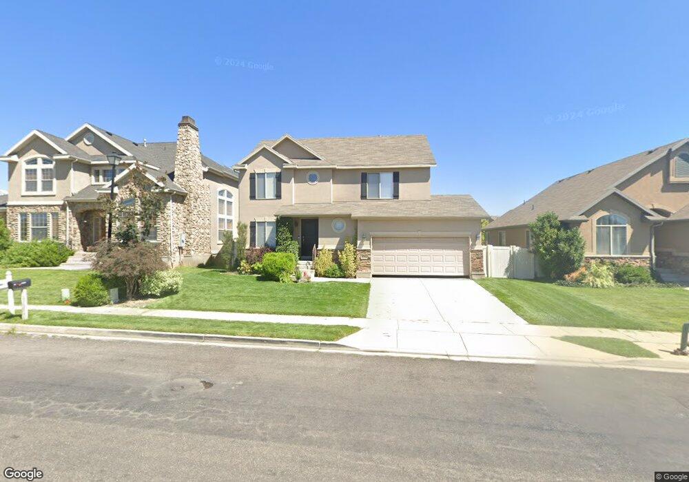
This home is located at 2256 N 2350 W, Lehi, UT 84043 and is currently estimated at $606,590, approximately $317 per square foot. 2256 N 2350 W is a home located in Utah County with nearby schools including Liberty Hills Elementary School, Skyridge High School, and Ascent Academies of Utah - Lehi Campus.
Ownership History
Date
Name
Owned For
Owner Type
Purchase Details
Closed on
Jan 31, 2013
Sold by
Hill Andrew M and Hill Amber
Bought by
Hill Andrew M and Hill Amber
Current Estimated Value
Home Financials for this Owner
Home Financials are based on the most recent Mortgage that was taken out on this home.
Original Mortgage
$260,075
Outstanding Balance
$181,133
Interest Rate
3.33%
Mortgage Type
New Conventional
Estimated Equity
$425,457
Purchase Details
Closed on
Jul 8, 2010
Sold by
Hill Andrew M and Hill Amber
Bought by
Hill Andrew M and Hill Amber
Purchase Details
Closed on
Jan 24, 2007
Sold by
Ivory Homes Ltd
Bought by
Hill Andrew M and Hill Amber
Home Financials for this Owner
Home Financials are based on the most recent Mortgage that was taken out on this home.
Original Mortgage
$270,576
Interest Rate
6.17%
Mortgage Type
Purchase Money Mortgage
Create a Home Valuation Report for This Property
The Home Valuation Report is an in-depth analysis detailing your home's value as well as a comparison with similar homes in the area
Home Values in the Area
Average Home Value in this Area
Purchase History
| Date | Buyer | Sale Price | Title Company |
|---|---|---|---|
| Hill Andrew M | -- | Title Source Inc | |
| Hill Andrew M | -- | Title Source Inc | |
| Hill Andrew M | -- | None Available | |
| Hill Andrew M | -- | Cottonwood Title | |
| Ivory Homes Ltd | -- | Cottonwood Title |
Source: Public Records
Mortgage History
| Date | Status | Borrower | Loan Amount |
|---|---|---|---|
| Open | Hill Andrew M | $260,075 | |
| Closed | Ivory Homes Ltd | $270,576 |
Source: Public Records
Tax History Compared to Growth
Tax History
| Year | Tax Paid | Tax Assessment Tax Assessment Total Assessment is a certain percentage of the fair market value that is determined by local assessors to be the total taxable value of land and additions on the property. | Land | Improvement |
|---|---|---|---|---|
| 2025 | $2,411 | $292,600 | $218,900 | $313,100 |
| 2024 | $2,411 | $282,205 | $0 | $0 |
| 2023 | $2,300 | $292,270 | $0 | $0 |
| 2022 | $2,481 | $305,635 | $0 | $0 |
| 2021 | $2,225 | $414,400 | $126,700 | $287,700 |
| 2020 | $2,098 | $386,200 | $117,300 | $268,900 |
| 2019 | $1,835 | $351,100 | $117,300 | $233,800 |
| 2018 | $1,765 | $319,300 | $110,600 | $208,700 |
| 2017 | $1,706 | $164,120 | $0 | $0 |
| 2016 | $1,736 | $154,935 | $0 | $0 |
| 2015 | $1,612 | $136,565 | $0 | $0 |
| 2014 | $1,556 | $131,065 | $0 | $0 |
Source: Public Records
Map
Nearby Homes
- 2196 N 2350 W
- 2464 W 2250 N
- 2189 N 2600 W
- 1968 N 2040 W Unit 40
- 1969 N 2040 St W
- 2013 N 2040 W
- 1990 N 2040 W
- 1990 N 2040 W Unit 41
- Huntington Plan at Pioneer Meadows
- Silver Lake Plan at Pioneer Meadows
- Summit Plan at Pioneer Meadows
- Palisade Plan at Pioneer Meadows
- 1970 N 2090 St W
- 1912 W 2250 N
- 1898 W Pointe Meadow Loop
- 1854 N 2230 W
- 1870 N 2230 W
- 1870 N 2230 W Unit 23
- 1896 N 2230 W
- 1908 N 2230 W