Estimated Value: $1,119,000 - $1,158,000
5
Beds
4
Baths
4,140
Sq Ft
$276/Sq Ft
Est. Value
About This Home
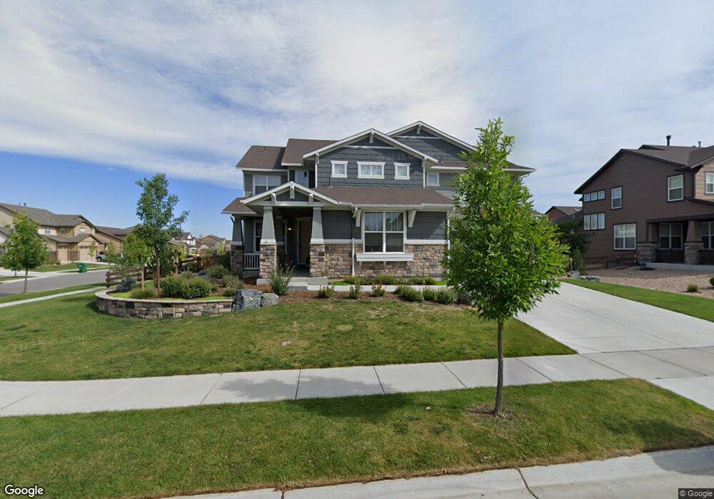
This home is located at 2257 Front Range Ct, Erie, CO 80516 and is currently estimated at $1,140,866, approximately $275 per square foot. 2257 Front Range Ct is a home with nearby schools including Meadowlark School, Centaurus High School, and Aspen Ridge Preparatory School.
Ownership History
Date
Name
Owned For
Owner Type
Purchase Details
Closed on
Feb 4, 2015
Sold by
Meritage Homes Of Colorado Inc
Bought by
Mayer Nicholas Robert
Current Estimated Value
Home Financials for this Owner
Home Financials are based on the most recent Mortgage that was taken out on this home.
Original Mortgage
$508,537
Outstanding Balance
$391,362
Interest Rate
3.89%
Mortgage Type
New Conventional
Estimated Equity
$749,504
Create a Home Valuation Report for This Property
The Home Valuation Report is an in-depth analysis detailing your home's value as well as a comparison with similar homes in the area
Home Values in the Area
Average Home Value in this Area
Purchase History
| Date | Buyer | Sale Price | Title Company |
|---|---|---|---|
| Mayer Nicholas Robert | $636,037 | None Available |
Source: Public Records
Mortgage History
| Date | Status | Borrower | Loan Amount |
|---|---|---|---|
| Open | Mayer Nicholas Robert | $508,537 |
Source: Public Records
Tax History Compared to Growth
Tax History
| Year | Tax Paid | Tax Assessment Tax Assessment Total Assessment is a certain percentage of the fair market value that is determined by local assessors to be the total taxable value of land and additions on the property. | Land | Improvement |
|---|---|---|---|---|
| 2025 | $10,092 | $72,601 | $14,463 | $58,138 |
| 2024 | $10,092 | $72,601 | $14,463 | $58,138 |
| 2023 | $12,159 | $74,484 | $19,242 | $58,927 |
| 2022 | $9,578 | $56,997 | $12,176 | $44,821 |
| 2021 | $9,578 | $58,637 | $12,527 | $46,110 |
| 2020 | $8,605 | $52,359 | $7,865 | $44,494 |
| 2019 | $8,534 | $52,359 | $7,865 | $44,494 |
| 2018 | $8,354 | $52,438 | $12,672 | $39,766 |
| 2017 | $8,013 | $57,973 | $14,010 | $43,963 |
| 2016 | $7,108 | $39,083 | $15,681 | $23,402 |
| 2015 | $5,920 | $19,285 | $19,285 | $0 |
| 2014 | -- | $0 | $0 | $0 |
Source: Public Records
Map
Nearby Homes
- 849 Dinosaur Dr
- 1182 Red Iron Ct
- 1205 Red Iron Ct
- 1195 Fox Hills Ct
- 620 Sundance Cir
- 825 Dakota Ln
- 972 Carbonate Ln
- 753 Carbonate Ln
- 690 Sundance Cir
- 936 Weston Cir
- 1426 Lyons Ln
- 2133 Fountain Cir
- 688 Brennan Cir
- 385 Baxter Farm Ln
- 671 Brennan Cir
- 374 Tynan Dr
- 165 Yellowfield Way
- 1779 Gordon Dr
- 1842 Southard St
- 1817 Powell St
- 2255 Front Range Ct
- 2266 Madison Dr
- 2264 Madison Dr
- 2253 Front Range Ct
- 2262 Front Range Rd
- 2256 Front Range Ct
- 2254 Front Range Ct
- 2260 Front Range Rd
- 2258 Front Range Ct
- 2262 Madison Dr
- 2266 Front Range Rd
- 2251 Front Range Ct
- 2268 Front Range Rd
- 2260 Madison Dr
- 2252 Front Range Ct
- 2269 Front Range Rd
- 926 Rocky Ridge Cir
- 932 Rocky Ridge Cir
- 920 Rocky Ridge Cir
- 918 Rocky Ridge Cir