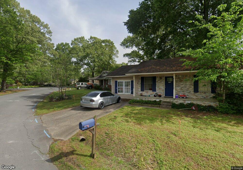
226 Cherrie Ave Sherwood, AR 72120
Estimated Value: $138,000 - $160,000
--
Bed
3
Baths
1,209
Sq Ft
$122/Sq Ft
Est. Value
About This Home
This home is located at 226 Cherrie Ave, Sherwood, AR 72120 and is currently estimated at $147,295, approximately $121 per square foot. 226 Cherrie Ave is a home located in Pulaski County with nearby schools including Oakbrooke Elementary School, Sylvan Hills Middle School, and Sylvan Hills High School.
Ownership History
Date
Name
Owned For
Owner Type
Purchase Details
Closed on
Mar 20, 2019
Sold by
Daymark Master Trust
Bought by
Bpdm Properties 2018 I Llc
Current Estimated Value
Home Financials for this Owner
Home Financials are based on the most recent Mortgage that was taken out on this home.
Original Mortgage
$50,000,000
Interest Rate
4.3%
Mortgage Type
Construction
Purchase Details
Closed on
Apr 7, 2016
Sold by
U S Bank Na
Bought by
Daymark Master Trust
Purchase Details
Closed on
Oct 1, 2015
Sold by
Thompson Pam
Bought by
U S Bank Na
Purchase Details
Closed on
Aug 18, 2005
Sold by
Bredensteiner Pam G and Thompson Pam G
Bought by
Thompson Pam G
Home Financials for this Owner
Home Financials are based on the most recent Mortgage that was taken out on this home.
Original Mortgage
$60,000
Interest Rate
7.8%
Mortgage Type
Stand Alone Refi Refinance Of Original Loan
Create a Home Valuation Report for This Property
The Home Valuation Report is an in-depth analysis detailing your home's value as well as a comparison with similar homes in the area
Home Values in the Area
Average Home Value in this Area
Purchase History
| Date | Buyer | Sale Price | Title Company |
|---|---|---|---|
| Bpdm Properties 2018 I Llc | $1,011,000 | None Available | |
| Daymark Master Trust | $41,000 | None Available | |
| U S Bank Na | $62,400 | None Available | |
| Thompson Pam G | -- | Transcontinental Title Co |
Source: Public Records
Mortgage History
| Date | Status | Borrower | Loan Amount |
|---|---|---|---|
| Closed | Bpdm Properties 2018 I Llc | $50,000,000 | |
| Previous Owner | Thompson Pam G | $60,000 |
Source: Public Records
Tax History Compared to Growth
Tax History
| Year | Tax Paid | Tax Assessment Tax Assessment Total Assessment is a certain percentage of the fair market value that is determined by local assessors to be the total taxable value of land and additions on the property. | Land | Improvement |
|---|---|---|---|---|
| 2025 | $1,061 | $20,374 | $3,200 | $17,174 |
| 2024 | $993 | $20,374 | $3,200 | $17,174 |
| 2023 | $993 | $20,374 | $3,200 | $17,174 |
| 2022 | $1,028 | $20,374 | $3,200 | $17,174 |
| 2021 | $916 | $15,880 | $3,300 | $12,580 |
| 2020 | $911 | $15,880 | $3,300 | $12,580 |
| 2019 | $911 | $15,880 | $3,300 | $12,580 |
| 2018 | $911 | $15,880 | $3,300 | $12,580 |
| 2017 | $904 | $15,880 | $3,300 | $12,580 |
| 2016 | $879 | $15,400 | $3,200 | $12,200 |
| 2015 | $670 | $13,190 | $3,200 | $9,990 |
| 2014 | $670 | $13,190 | $3,200 | $9,990 |
Source: Public Records
Map
Nearby Homes
- 114 May St
- 208 Calloway Ave
- 309 May St
- 300 Calloway Ave
- Lot 2 Witts Dr
- Lot 1 Witts Dr
- 400 Cherrie Ave
- 401 Calloway Ave
- 3116 Maxine Ave
- 404 May St
- 208 Ann Ave
- 110 Ann Ave
- 608 Hemphill Rd
- 604 Grandview St
- 2712 E Maryland Ave
- 3600 E Kiehl Ave
- 8604 Northgate Dr
- 5908 Glenhaven Place
- 124 Obsidian Dr
- 109 Carnelian Dr
- 226 Cherrie Ave
- 224 Cherrie Ave
- 209 May St
- 424 Hemphill Rd
- 501 Hemphill Rd
- 205 May St
- 0 Cherrie Ave Unit 15027632
- 0 Cherrie Ave Unit 16002164
- 0 Cherrie Ave Unit 20037930
- 0 Cherrie Ave Unit 21021680
- 00 Cherrie Ave
- 301 May St
- 220 Cherrie Ave
- 201 May St
- 0 May Ave
- 303 May St
- 500 Hemphill Rd
- 503 Hemphill Rd
- 304 Cherrie Ave
- 208 May St