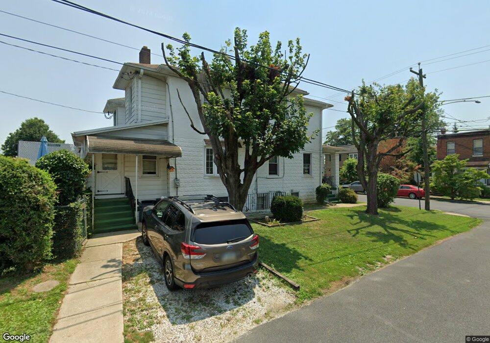
226 Forrest Ave Folsom, PA 19033
Estimated Value: $282,000 - $304,000
3
Beds
2
Baths
1,262
Sq Ft
$232/Sq Ft
Est. Value
About This Home
This home is located at 226 Forrest Ave, Folsom, PA 19033 and is currently estimated at $293,089, approximately $232 per square foot. 226 Forrest Ave is a home located in Delaware County with nearby schools including Grace Park Elementary School, Ridley Middle School, and Ridley High School.
Ownership History
Date
Name
Owned For
Owner Type
Purchase Details
Closed on
Oct 26, 1995
Sold by
Donato Frank and Donato Carmen J
Bought by
Griffin David R and Griffin Amy A
Current Estimated Value
Home Financials for this Owner
Home Financials are based on the most recent Mortgage that was taken out on this home.
Original Mortgage
$89,928
Outstanding Balance
$1,256
Interest Rate
7.58%
Mortgage Type
FHA
Estimated Equity
$291,833
Create a Home Valuation Report for This Property
The Home Valuation Report is an in-depth analysis detailing your home's value as well as a comparison with similar homes in the area
Home Values in the Area
Average Home Value in this Area
Purchase History
| Date | Buyer | Sale Price | Title Company |
|---|---|---|---|
| Griffin David R | $90,000 | -- |
Source: Public Records
Mortgage History
| Date | Status | Borrower | Loan Amount |
|---|---|---|---|
| Open | Griffin David R | $89,928 |
Source: Public Records
Tax History Compared to Growth
Tax History
| Year | Tax Paid | Tax Assessment Tax Assessment Total Assessment is a certain percentage of the fair market value that is determined by local assessors to be the total taxable value of land and additions on the property. | Land | Improvement |
|---|---|---|---|---|
| 2025 | $5,592 | $161,050 | $53,750 | $107,300 |
| 2024 | $5,592 | $161,050 | $53,750 | $107,300 |
| 2023 | $5,349 | $161,050 | $53,750 | $107,300 |
| 2022 | $5,177 | $161,050 | $53,750 | $107,300 |
| 2021 | $8,014 | $161,050 | $53,750 | $107,300 |
| 2020 | $4,976 | $88,090 | $32,260 | $55,830 |
| 2019 | $4,885 | $88,090 | $32,260 | $55,830 |
| 2018 | $4,824 | $88,090 | $0 | $0 |
| 2017 | $4,824 | $88,090 | $0 | $0 |
| 2016 | $493 | $88,090 | $0 | $0 |
| 2015 | $483 | $88,090 | $0 | $0 |
| 2014 | $483 | $88,090 | $0 | $0 |
Source: Public Records
Map
Nearby Homes
- 290 Morris Ave
- 234 Virginia Ave
- 147 Haverford Rd
- 167 & 171 Garfield Ave
- 129 Garfield Ave
- 1126 Grant Ave
- 525 Kelly Ave
- 205 W Rodgers St
- 319 Fairview Rd
- 1115 7th Ave
- 610 N Swarthmore Ave
- 608 Milmont Ave
- 515 Harrison St
- 1412 Donna Ave
- 0 Harrison St
- 265 W Ridley Ave
- 802 Fairview Rd
- 405 N Swarthmore Ave
- 415 Tome St
- 332 Holland St
- 224 Forrest Ave
- 220 Forrest Ave
- 230 Forrest Ave
- 225 Ohio Ave
- 216 Forrest Ave
- 223 Ohio Ave
- 221 Ohio Ave
- 707 Reese St
- 219 Ohio Ave
- 223 Ohio Ave
- 215 Ohio Ave
- 214 Forrest Ave
- 223 Forrest Ave
- 703 Reese St
- 219 Forrest Ave
- 211 Ohio Ave
- 225 Forrest Ave
- 712 Macdade Blvd Unit 125
- 712 Macdade Blvd
- 213 Forrest Ave