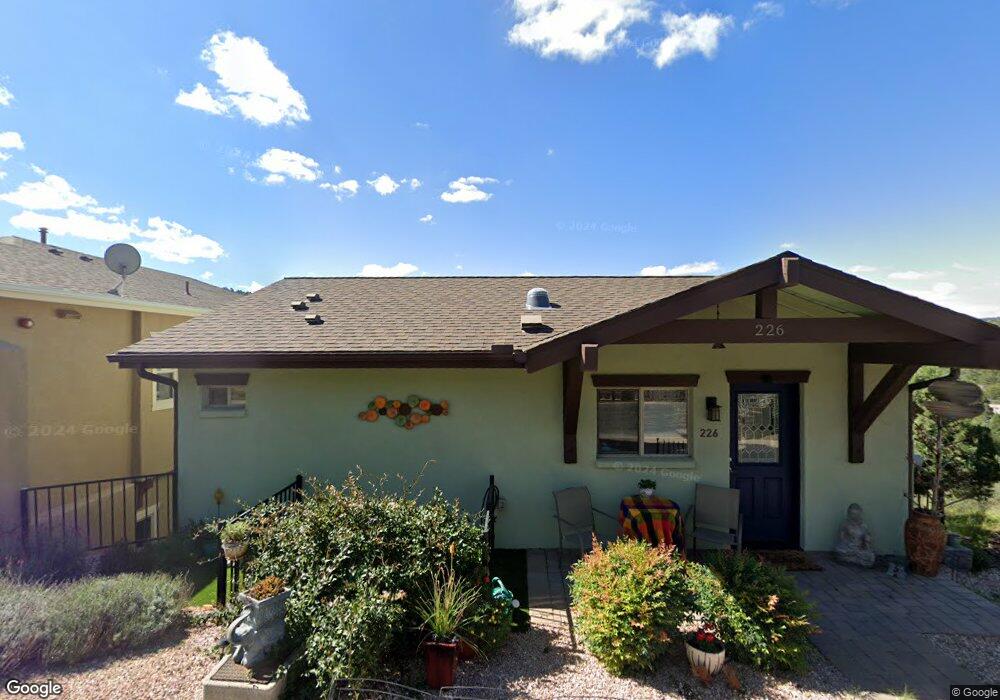
226 Jacob Ln Prescott, AZ 86303
Estimated Value: $482,782 - $625,000
Studio
--
Bath
1,518
Sq Ft
$345/Sq Ft
Est. Value
About This Home
This home is located at 226 Jacob Ln, Prescott, AZ 86303 and is currently estimated at $523,196, approximately $344 per square foot. 226 Jacob Ln is a home located in Yavapai County with nearby schools including Taylor Hicks School, Granite Mountain Middle School, and Prescott Mile High Middle School.
Ownership History
Date
Name
Owned For
Owner Type
Purchase Details
Closed on
Sep 26, 2022
Sold by
Hartman Claudia
Bought by
Tuckey Suzanne
Current Estimated Value
Purchase Details
Closed on
May 4, 2021
Sold by
Hoover Gladys P
Bought by
Shure Donald and Hartman Claudia
Home Financials for this Owner
Home Financials are based on the most recent Mortgage that was taken out on this home.
Original Mortgage
$259,500
Interest Rate
3.1%
Mortgage Type
Seller Take Back
Purchase Details
Closed on
Jun 12, 2014
Sold by
Williams Edmund C
Bought by
Hoover Gladys P
Purchase Details
Closed on
Sep 11, 2013
Sold by
Williams Jennifer
Bought by
Williams Edmund C
Purchase Details
Closed on
Aug 16, 2005
Sold by
Herrle Dennis and Herrle Karen
Bought by
Williams Edmund C and Williams Jennifer
Purchase Details
Closed on
Oct 15, 2003
Sold by
Manzanita Village Llc
Bought by
Herrle Dennis and Herrle Karen
Create a Home Valuation Report for This Property
The Home Valuation Report is an in-depth analysis detailing your home's value as well as a comparison with similar homes in the area
Purchase History
| Date | Buyer | Sale Price | Title Company |
|---|---|---|---|
| Tuckey Suzanne | $450,000 | First American Title | |
| Shure Donald | $330,000 | Yavapai Title Agency | |
| Hoover Gladys P | $37,500 | Pioneer Title Agency | |
| Williams Edmund C | -- | None Available | |
| Williams Edmund C | $66,000 | Pioneer Title Agency Inc | |
| Herrle Dennis | $50,000 | Pioneer Title Agency |
Source: Public Records
Mortgage History
| Date | Status | Borrower | Loan Amount |
|---|---|---|---|
| Previous Owner | Shure Donald | $259,500 |
Source: Public Records
Tax History
| Year | Tax Paid | Tax Assessment Tax Assessment Total Assessment is a certain percentage of the fair market value that is determined by local assessors to be the total taxable value of land and additions on the property. | Land | Improvement |
|---|---|---|---|---|
| 2026 | $1,189 | $41,525 | -- | -- |
| 2024 | $1,164 | $41,210 | -- | -- |
| 2023 | $1,164 | $32,925 | $5,996 | $26,929 |
| 2022 | $1,148 | $28,071 | $5,890 | $22,181 |
| 2021 | $1,232 | $27,617 | $5,117 | $22,500 |
| 2020 | $1,463 | $0 | $0 | $0 |
| 2019 | $1,445 | $0 | $0 | $0 |
| 2018 | $1,394 | $0 | $0 | $0 |
| 2017 | $1,329 | $0 | $0 | $0 |
| 2016 | $482 | $0 | $0 | $0 |
| 2015 | $518 | $0 | $0 | $0 |
| 2014 | $545 | $0 | $0 | $0 |
Source: Public Records
Map
Nearby Homes
- 219 Looking Glass Dr
- 223 Looking Glass Dr
- 236 Looking Glass Dr Unit 26
- 231 Looking Glass Dr
- 235 Looking Glass Dr
- 277 Jacob Ln
- 247 Looking Glass Dr
- 251 Looking Glass Dr
- 259 Looking Glass Dr Unit Lot8
- 239 Point of View
- 303 Double d Dr
- 1001 E Goodwin St Unit 101
- 450 Broadview Dr
- 450 Broadview Dr Unit 38
- 803 E Carleton St
- 550 Eastwood Place
- 300 Newport Dr
- 144 S Penn Ave
- 518 Quail Hollow Dr
- 610 Pauley Dr
Your Personal Tour Guide
Ask me questions while you tour the home.