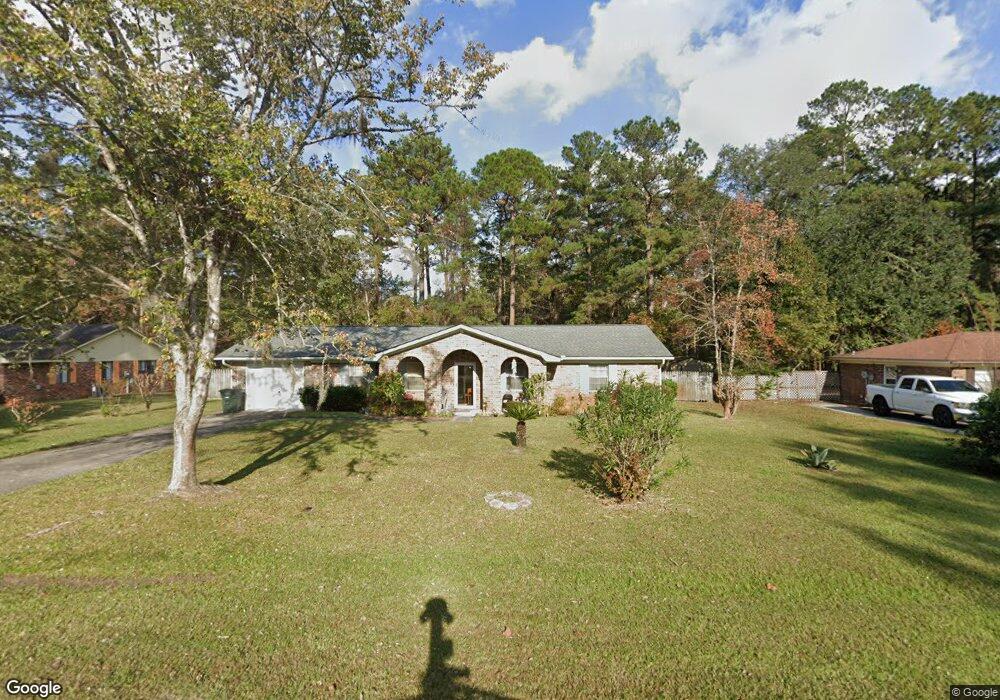
226 Thiess Branch Dr Hinesville, GA 31313
Estimated Value: $204,000 - $239,000
3
Beds
2
Baths
1,404
Sq Ft
$160/Sq Ft
Est. Value
About This Home
This home is located at 226 Thiess Branch Dr, Hinesville, GA 31313 and is currently estimated at $224,733, approximately $160 per square foot. 226 Thiess Branch Dr is a home located in Liberty County with nearby schools including Joseph Martin Elementary School, Midway Middle School, and Liberty County High School.
Ownership History
Date
Name
Owned For
Owner Type
Purchase Details
Closed on
Feb 5, 2024
Sold by
Clarke Ancata Allen
Bought by
Clarke Ancata and Taylor Ina Anestena
Current Estimated Value
Purchase Details
Closed on
Aug 25, 2009
Sold by
Clarke John Vincent
Bought by
Clarke Ancata Allen
Purchase Details
Closed on
Jan 29, 1999
Sold by
Vanhoomissen Bernard
Bought by
Clarke John V and Clarke Anca
Purchase Details
Closed on
May 21, 1996
Sold by
Grenelle Rosalie T
Bought by
Vanhoomissen Bernard
Purchase Details
Closed on
Sep 17, 1986
Bought by
Grenelle Rosalie T
Create a Home Valuation Report for This Property
The Home Valuation Report is an in-depth analysis detailing your home's value as well as a comparison with similar homes in the area
Home Values in the Area
Average Home Value in this Area
Purchase History
| Date | Buyer | Sale Price | Title Company |
|---|---|---|---|
| Clarke Ancata | $154,000 | -- | |
| Clarke Ancata Allen | -- | -- | |
| Clarke John V | $76,500 | -- | |
| Vanhoomissen Bernard | $76,000 | -- | |
| Grenelle Rosalie T | -- | -- |
Source: Public Records
Tax History Compared to Growth
Tax History
| Year | Tax Paid | Tax Assessment Tax Assessment Total Assessment is a certain percentage of the fair market value that is determined by local assessors to be the total taxable value of land and additions on the property. | Land | Improvement |
|---|---|---|---|---|
| 2024 | $2,486 | $81,792 | $12,000 | $69,792 |
| 2023 | $2,486 | $73,608 | $12,000 | $61,608 |
| 2022 | $1,888 | $55,354 | $9,600 | $45,754 |
| 2021 | $1,701 | $50,721 | $9,600 | $41,121 |
| 2020 | $1,327 | $42,624 | $9,200 | $33,424 |
| 2019 | $1,318 | $42,624 | $9,200 | $33,424 |
| 2018 | $843 | $32,614 | $5,200 | $27,414 |
| 2017 | $1,074 | $32,614 | $5,200 | $27,414 |
| 2016 | $758 | $31,336 | $5,200 | $26,136 |
| 2015 | $1,273 | $31,336 | $5,200 | $26,136 |
| 2014 | $1,273 | $42,424 | $8,000 | $34,424 |
| 2013 | -- | $48,080 | $8,000 | $40,080 |
Source: Public Records
Map
Nearby Homes
- 76 Boundary Hal Way
- 12 Boundary Hal Way
- 412 Timberlane Cir
- 614 S Main St
- 480 Dykes St
- 614 2nd St
- 402 W Oglethorpe Hwy
- 332 Mortar Place
- 506 Eisenhower Dr
- 314 York Ln
- 810 Hod Ln
- 148 Marron Way
- 727 S Main St Unit 20
- 727 S Main St Unit 60
- 727 S Main St Unit 42
- 980 Grayson Ave
- 1078 Grayson Ave
- 864 Grayson Ave
- 804 Grayson Ave
- 224 Thiess Branch Dr
- 228 Thiess Branch Dr
- 0 Thiess Branch Dr
- 227 Thiess Branch Dr
- 222 Thiess Branch Dr
- 446 Timberlane Cir
- 446 Timberlane Cir
- 558 Briar Cir
- 569 Huckleberry Ln
- 220 Thiess Branch Dr
- 568 Huckleberry Ln
- 564 Briar Cir
- 568 Briar Cir
- 571 Huckleberry Ln
- 572 Huckleberry Ln
- 214 Thiess Branch Dr
- 572 Briar Cir
- 561 Briar Cir
- 218 Thiess Branch Dr Unit n/a
- 218 Thiess Branch Dr