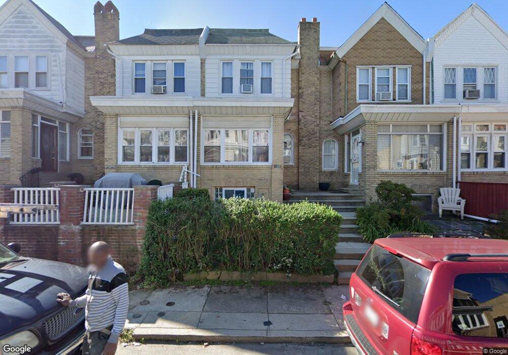
226 Wembly Rd Upper Darby, PA 19082
Estimated Value: $129,000 - $225,000
3
Beds
2
Baths
1,415
Sq Ft
$139/Sq Ft
Est. Value
About This Home
This home is located at 226 Wembly Rd, Upper Darby, PA 19082 and is currently estimated at $196,054, approximately $138 per square foot. 226 Wembly Rd is a home located in Delaware County with nearby schools including Bywood Elementary School, Upper Darby Kdg Center, and Upper Darby High School.
Ownership History
Date
Name
Owned For
Owner Type
Purchase Details
Closed on
Mar 5, 2013
Sold by
Leung Juanita
Bought by
Leugn Juanita and Leung Carlos A
Current Estimated Value
Purchase Details
Closed on
May 3, 2011
Sold by
Federal National Mortgage Association
Bought by
Leung Juanita
Purchase Details
Closed on
Jun 29, 2007
Sold by
Amin Mohammed N
Bought by
Miage Mohammed
Home Financials for this Owner
Home Financials are based on the most recent Mortgage that was taken out on this home.
Original Mortgage
$121,600
Interest Rate
6.39%
Mortgage Type
Purchase Money Mortgage
Purchase Details
Closed on
Sep 19, 2000
Sold by
Basitanelli Guido F
Bought by
Ayoo Joseph
Home Financials for this Owner
Home Financials are based on the most recent Mortgage that was taken out on this home.
Original Mortgage
$45,000
Interest Rate
12.25%
Mortgage Type
Purchase Money Mortgage
Create a Home Valuation Report for This Property
The Home Valuation Report is an in-depth analysis detailing your home's value as well as a comparison with similar homes in the area
Home Values in the Area
Average Home Value in this Area
Purchase History
| Date | Buyer | Sale Price | Title Company |
|---|---|---|---|
| Leugn Juanita | -- | None Available | |
| Leung Juanita | $52,000 | None Available | |
| Miage Mohammed | $128,000 | None Available | |
| Ayoo Joseph | $50,000 | Commonwealth Land Title Ins |
Source: Public Records
Mortgage History
| Date | Status | Borrower | Loan Amount |
|---|---|---|---|
| Previous Owner | Miage Mohammed | $121,600 | |
| Previous Owner | Ayoo Joseph | $45,000 | |
| Closed | Ayoo Joseph | $2,500 |
Source: Public Records
Tax History
| Year | Tax Paid | Tax Assessment Tax Assessment Total Assessment is a certain percentage of the fair market value that is determined by local assessors to be the total taxable value of land and additions on the property. | Land | Improvement |
|---|---|---|---|---|
| 2025 | $3,792 | $89,660 | $22,140 | $67,520 |
| 2024 | $3,792 | $89,660 | $22,140 | $67,520 |
| 2023 | $3,756 | $89,660 | $22,140 | $67,520 |
| 2022 | $3,655 | $89,660 | $22,140 | $67,520 |
| 2021 | $4,928 | $89,660 | $22,140 | $67,520 |
| 2020 | $3,405 | $52,640 | $17,220 | $35,420 |
| 2019 | $3,345 | $52,640 | $17,220 | $35,420 |
| 2018 | $3,307 | $52,640 | $0 | $0 |
| 2017 | $3,221 | $52,640 | $0 | $0 |
| 2016 | $289 | $52,640 | $0 | $0 |
| 2015 | $295 | $52,640 | $0 | $0 |
| 2014 | $289 | $52,640 | $0 | $0 |
Source: Public Records
Map
Nearby Homes
- 312 Wiltshire Rd
- 321 Hampden Rd
- 411 Millbank Rd
- 424 Woodcliffe Rd
- 138 Richfield Rd
- 232 Copley Rd
- 210 Copley Rd
- 212 Copley Rd
- 418 Littlecroft Rd Unit 6A
- 345 Copley Rd
- 233 Barrington Rd
- 337 Copley Rd
- 418 Hampden Rd
- 213 Heather Rd
- 247 Heather Rd
- 513 Woodcliffe Rd
- 417 Copley Rd
- 519 Littlecroft Rd
- 6805 Marshall Rd
- 432 Grace Rd
- 230 Wembly Rd
- 228 Wembly Rd
- 255 Richfield Rd
- 308 Maypole Rd
- 254 Maypole Rd
- 251 Richfield Rd
- 310 Maypole Rd
- 249 Richfield Rd
- 273 Wembly Rd
- 312 Maypole Rd
- 275 Wembly Rd
- 271 Wembly Rd
- 247 Richfield Rd
- 250 Maypole Rd
- 330 Maypole Rd
- 245 Richfield Rd
- 248 Maypole Rd
- 334 Maypole Rd
- 314 Richfield Rd
- 243 Richfield Rd
Your Personal Tour Guide
Ask me questions while you tour the home.