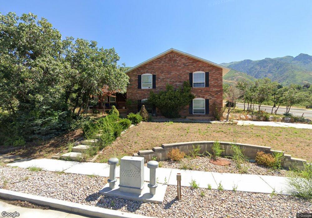
2264 N 2650 E Layton, UT 84040
Estimated Value: $646,000 - $700,612
5
Beds
4
Baths
3,482
Sq Ft
$194/Sq Ft
Est. Value
About This Home
This home is located at 2264 N 2650 E, Layton, UT 84040 and is currently estimated at $673,903, approximately $193 per square foot. 2264 N 2650 E is a home located in Davis County with nearby schools including Sarah Jane Adams Elementary School, North Layton Junior High School, and Northridge High School.
Ownership History
Date
Name
Owned For
Owner Type
Purchase Details
Closed on
Mar 23, 2009
Sold by
Brennan Timothy C
Bought by
Brennan Timothy C and Brennan Eriko T
Current Estimated Value
Home Financials for this Owner
Home Financials are based on the most recent Mortgage that was taken out on this home.
Original Mortgage
$268,000
Outstanding Balance
$166,647
Interest Rate
5.04%
Mortgage Type
VA
Estimated Equity
$507,256
Purchase Details
Closed on
Jan 10, 2005
Sold by
Nlblack Judith Ann
Bought by
Niblack Steven J and Niblack Cathy A
Home Financials for this Owner
Home Financials are based on the most recent Mortgage that was taken out on this home.
Original Mortgage
$225,000
Interest Rate
5.7%
Mortgage Type
New Conventional
Purchase Details
Closed on
Jan 7, 2005
Sold by
Ann Niblack Judith and Judith Ann Niblack Trust
Bought by
Niblack Steven J and Niblack Cathy A
Home Financials for this Owner
Home Financials are based on the most recent Mortgage that was taken out on this home.
Original Mortgage
$225,000
Interest Rate
5.7%
Mortgage Type
New Conventional
Create a Home Valuation Report for This Property
The Home Valuation Report is an in-depth analysis detailing your home's value as well as a comparison with similar homes in the area
Home Values in the Area
Average Home Value in this Area
Purchase History
| Date | Buyer | Sale Price | Title Company |
|---|---|---|---|
| Brennan Timothy C | -- | Mountain View Title | |
| Brennan Timothy C | -- | First American Title | |
| Niblack Steven J | -- | None Available | |
| Niblack Steven J | -- | Backman Stewart Title Svcs |
Source: Public Records
Mortgage History
| Date | Status | Borrower | Loan Amount |
|---|---|---|---|
| Open | Brennan Timothy C | $268,000 | |
| Previous Owner | Niblack Steven J | $225,000 | |
| Closed | Niblack Steven J | $0 |
Source: Public Records
Tax History
| Year | Tax Paid | Tax Assessment Tax Assessment Total Assessment is a certain percentage of the fair market value that is determined by local assessors to be the total taxable value of land and additions on the property. | Land | Improvement |
|---|---|---|---|---|
| 2025 | $3,608 | $354,200 | $130,089 | $224,111 |
| 2024 | $3,403 | $338,250 | $150,540 | $187,710 |
| 2023 | $3,358 | $593,000 | $198,443 | $394,557 |
| 2022 | $3,425 | $600,000 | $194,252 | $405,748 |
| 2021 | $3,215 | $462,000 | $163,232 | $298,768 |
| 2020 | $3,032 | $418,000 | $134,714 | $283,286 |
| 2019 | $2,814 | $381,000 | $119,788 | $261,212 |
| 2018 | $2,568 | $349,000 | $95,252 | $253,748 |
| 2016 | $2,310 | $164,065 | $49,714 | $114,351 |
| 2015 | $2,404 | $163,130 | $49,714 | $113,416 |
| 2014 | $1,364 | $167,965 | $49,714 | $118,251 |
| 2013 | -- | $151,117 | $33,932 | $117,185 |
Source: Public Records
Map
Nearby Homes
- 2563 E 2250 N
- 2136 N 2800 E
- 1954 N 2600 E
- 2547 E 1900 N
- 2509 E 1900 N
- 2569 N 2900 E
- 2597 N 2300 E
- 1907 N Bridge Ct
- 2391 Kays Creek Dr
- 1960 N 2150 E
- 2340 N 2050 E
- 2273 N 1975 E
- 1752 N Valley View Dr
- 2231 N Valley View Dr
- 1870 N Valley View Dr Unit 201
- 2353 Canyon View Dr
- 2189 N 1950 E
- 1332 N 2350 E
- 2124 E Cherry Ln
- 1843 Hayes Dr
- 2248 N 2650 E
- 2227 N 2650 E
- 2664 E 2000 N
- 2252 N 2650 E
- 2235 N 2650 E
- 2664 E Antelope Dr
- 2556 E 2250 N
- 2646 E Antelope Dr
- 2110 N 2600 E
- 2697 Sky View Dr
- 2208 N 2600 E
- 2628 E Antelope Dr
- 2701 Sky View Dr
- 2297 N 2600 E
- 2612 E Antelope Dr
- 2708 Sky View Dr
- 2551 E 2250 N
- 2173 N 2600 E
- 2561 E 2050 N
- 2215 N 2600 E
Your Personal Tour Guide
Ask me questions while you tour the home.