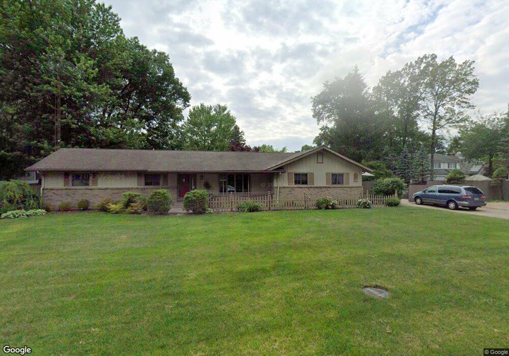
2265 Manoa Rd Toledo, OH 43615
Estimated Value: $261,000 - $296,000
3
Beds
2
Baths
1,920
Sq Ft
$143/Sq Ft
Est. Value
About This Home
This home is located at 2265 Manoa Rd, Toledo, OH 43615 and is currently estimated at $275,086, approximately $143 per square foot. 2265 Manoa Rd is a home located in Lucas County with nearby schools including Stranahan Elementary School, Sylvania Timberstone Junior High School, and Sylvania Southview High School.
Ownership History
Date
Name
Owned For
Owner Type
Purchase Details
Closed on
Mar 3, 2021
Sold by
Roznowski Suzanne G and Roznowski David J
Bought by
Roznowski David J
Current Estimated Value
Purchase Details
Closed on
May 7, 1998
Sold by
Gonia Thomas D
Bought by
Roznowski David J and Roznowski Suzanne G
Home Financials for this Owner
Home Financials are based on the most recent Mortgage that was taken out on this home.
Original Mortgage
$55,000
Interest Rate
7.2%
Create a Home Valuation Report for This Property
The Home Valuation Report is an in-depth analysis detailing your home's value as well as a comparison with similar homes in the area
Home Values in the Area
Average Home Value in this Area
Purchase History
| Date | Buyer | Sale Price | Title Company |
|---|---|---|---|
| Roznowski David J | -- | None Available | |
| Roznowski David J | $144,900 | Louisville Title Agency For |
Source: Public Records
Mortgage History
| Date | Status | Borrower | Loan Amount |
|---|---|---|---|
| Closed | Roznowski David J | $55,000 |
Source: Public Records
Tax History
| Year | Tax Paid | Tax Assessment Tax Assessment Total Assessment is a certain percentage of the fair market value that is determined by local assessors to be the total taxable value of land and additions on the property. | Land | Improvement |
|---|---|---|---|---|
| 2025 | -- | $74,340 | $14,070 | $60,270 |
| 2024 | $2,093 | $74,340 | $14,070 | $60,270 |
| 2023 | $3,356 | $53,410 | $11,025 | $42,385 |
| 2022 | $3,385 | $53,410 | $11,025 | $42,385 |
| 2021 | $3,467 | $53,410 | $11,025 | $42,385 |
| 2020 | $3,510 | $48,790 | $10,815 | $37,975 |
| 2019 | $3,382 | $48,790 | $10,815 | $37,975 |
| 2018 | $3,319 | $48,790 | $10,815 | $37,975 |
| 2017 | $3,525 | $46,830 | $10,500 | $36,330 |
| 2016 | $3,458 | $133,800 | $30,000 | $103,800 |
| 2015 | $3,262 | $133,800 | $30,000 | $103,800 |
| 2014 | $3,053 | $45,010 | $10,080 | $34,930 |
| 2013 | $3,053 | $45,010 | $10,080 | $34,930 |
Source: Public Records
Map
Nearby Homes
- 2355 Parliament Square
- 6755 Cloister Ct
- 2132 The Bluffs Unit 2132
- 2402 Cheshire Woods Rd
- 1809 Birdie Dr
- 7035 Mourning Dove Ct
- 6753 Carrie Pine Ln
- 6241 W Pembridge Dr
- 7043 Mourning Dove Ct
- 1714 Deer Trail Dr
- 6955 Dorr St
- 1015 Plumcreek Rd
- 7032 Cinnamon Teal Ct
- 2714 Sweetbriar Ct Unit 2714
- 2015 Oakside Rd
- 2010 Oakside Rd
- 2757 Sweetbriar Ct Unit 2757
- 2004 Oakside Rd
- 5925 Haefner Rd
- 1137 Bedford Woods Dr
- 2313 Manoa Ln N
- 2253 Manoa Rd
- 2253 Manoa Rd
- 2304 N Mccord Rd
- 2262 N Mccord Rd
- 2256 N Mccord Rd
- 2318 N Mccord Rd
- 2256 Manoa Rd
- 2250 Manoa Rd
- 2267 Ronaldo Rd
- 2246 N Mccord Rd
- 2322 Manoa Rd
- 2327 Manoa Ln N
- 2328 N Mccord Rd
- 2261 Ronaldo Rd
- 2242 N Mccord Rd
- 2236 Manoa Rd
- 2318 Parliament Square
- 2236 N Mccord Rd
Your Personal Tour Guide
Ask me questions while you tour the home.