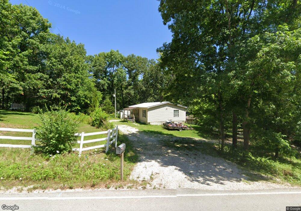
2267 Highway F Wright City, MO 63390
Estimated Value: $299,000 - $323,384
--
Bed
--
Bath
--
Sq Ft
2.21
Acres
About This Home
This home is located at 2267 Highway F, Wright City, MO 63390 and is currently estimated at $310,461. 2267 Highway F is a home with nearby schools including Wright City West Elementary School, Wright City East Elementary School, and Wright City Middle School.
Ownership History
Date
Name
Owned For
Owner Type
Purchase Details
Closed on
Aug 29, 2019
Sold by
Dj Properties Llc
Bought by
Mbm Property Inv Llc
Current Estimated Value
Home Financials for this Owner
Home Financials are based on the most recent Mortgage that was taken out on this home.
Original Mortgage
$60,000
Outstanding Balance
$52,663
Interest Rate
3.7%
Mortgage Type
New Conventional
Estimated Equity
$257,798
Create a Home Valuation Report for This Property
The Home Valuation Report is an in-depth analysis detailing your home's value as well as a comparison with similar homes in the area
Home Values in the Area
Average Home Value in this Area
Purchase History
| Date | Buyer | Sale Price | Title Company |
|---|---|---|---|
| Mbm Property Inv Llc | -- | Continental Land Title |
Source: Public Records
Mortgage History
| Date | Status | Borrower | Loan Amount |
|---|---|---|---|
| Open | Mbm Property Inv Llc | $60,000 |
Source: Public Records
Tax History Compared to Growth
Tax History
| Year | Tax Paid | Tax Assessment Tax Assessment Total Assessment is a certain percentage of the fair market value that is determined by local assessors to be the total taxable value of land and additions on the property. | Land | Improvement |
|---|---|---|---|---|
| 2024 | $446 | $7,289 | $2,643 | $4,646 |
| 2023 | $446 | $7,289 | $2,643 | $4,646 |
| 2022 | $415 | $6,749 | $2,447 | $4,302 |
| 2021 | $415 | $6,749 | $2,447 | $4,302 |
| 2020 | $416 | $6,749 | $2,447 | $4,302 |
| 2019 | $415 | $6,749 | $0 | $0 |
| 2017 | $400 | $6,749 | $0 | $0 |
| 2016 | $400 | $6,749 | $0 | $0 |
| 2015 | -- | $6,749 | $0 | $0 |
| 2011 | -- | $6,750 | $0 | $0 |
Source: Public Records
Map
Nearby Homes
- 0-1 Mark Peterson Dr
- 0 Mark Peterson Dr
- 2105 Meadow Ridge Dr
- 2692 Klor Lane Dr
- 185 Hirshweg Dr
- 2142 Meadow Valley Dr
- 2697 Tyrolean Way Dr
- 634 Wunderbar Point Dr
- 2740 Tyrol View Ct
- 23001 Abrolat Rd
- 142 Geneva Cove Dr
- 23023 Abrolat Tract 4
- 23023 Abrolat Tract 3
- 23012 Abrolat Tract 7
- 23001 Abrolat Tract 6
- 23001 Abrolat Tract 5
- 23001 Abrolat Tract 2
- 22643 Abrolat Tract 1
- 152 Geneva Cove Dr
- 14742 Madison Ln
- 2275 Highway F
- 24114 Tranquil Oaks
- 2256 Highway F
- 24101 Tranquil Oaks
- 12 Tranquil Oaks Unit OAKS
- 24231 Tranquil Oaks Unit 5
- 16 Mark Peterson Dr
- 24260 Tranquil Oaks Unit 7
- 2268 Highway F
- 24253 Tranquil Oaks
- 23986 Cardinal Ln
- 23947 Cardinal Ln
- 201 Hybl Dr
- 207 Hybl Dr
- 2274 Highway F
- 23933 Cardinal Ln
- 23784 Kit Dr
- 0 Cardinal Ln
- 2262 Highway F
- 23802 Mark Peterson Dr