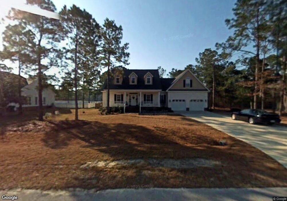
227 Egret Point Dr Sneads Ferry, NC 28460
Estimated Value: $380,371 - $446,000
4
Beds
2
Baths
2,300
Sq Ft
$179/Sq Ft
Est. Value
About This Home
This home is located at 227 Egret Point Dr, Sneads Ferry, NC 28460 and is currently estimated at $412,843, approximately $179 per square foot. 227 Egret Point Dr is a home located in Onslow County with nearby schools including Coastal Elementary, Dixon Elementary School, and Dixon High School.
Ownership History
Date
Name
Owned For
Owner Type
Purchase Details
Closed on
Nov 30, 2006
Sold by
Whitfield Neil and Whitfield Teresa
Bought by
Hudspeth Nelson Lawrence and Hudspeth Anne Romaniw
Current Estimated Value
Home Financials for this Owner
Home Financials are based on the most recent Mortgage that was taken out on this home.
Original Mortgage
$231,200
Outstanding Balance
$138,383
Interest Rate
6.33%
Mortgage Type
Purchase Money Mortgage
Estimated Equity
$274,460
Create a Home Valuation Report for This Property
The Home Valuation Report is an in-depth analysis detailing your home's value as well as a comparison with similar homes in the area
Home Values in the Area
Average Home Value in this Area
Purchase History
| Date | Buyer | Sale Price | Title Company |
|---|---|---|---|
| Hudspeth Nelson Lawrence | $289,000 | None Available |
Source: Public Records
Mortgage History
| Date | Status | Borrower | Loan Amount |
|---|---|---|---|
| Open | Hudspeth Nelson Lawrence | $231,200 |
Source: Public Records
Tax History Compared to Growth
Tax History
| Year | Tax Paid | Tax Assessment Tax Assessment Total Assessment is a certain percentage of the fair market value that is determined by local assessors to be the total taxable value of land and additions on the property. | Land | Improvement |
|---|---|---|---|---|
| 2025 | $2,034 | $310,513 | $45,000 | $265,513 |
| 2024 | $2,034 | $310,513 | $45,000 | $265,513 |
| 2023 | $2,034 | $310,513 | $45,000 | $265,513 |
| 2022 | $2,034 | $310,513 | $45,000 | $265,513 |
| 2021 | $1,593 | $225,910 | $45,000 | $180,910 |
| 2020 | $1,593 | $225,910 | $45,000 | $180,910 |
| 2019 | $1,593 | $225,910 | $45,000 | $180,910 |
| 2018 | $1,593 | $225,910 | $45,000 | $180,910 |
| 2017 | $1,458 | $215,960 | $43,500 | $172,460 |
| 2016 | $1,458 | $215,960 | $0 | $0 |
| 2015 | $1,458 | $215,960 | $0 | $0 |
| 2014 | $1,458 | $215,960 | $0 | $0 |
Source: Public Records
Map
Nearby Homes
- 205 Egret Point Dr
- 106 Blue Heron Cir
- 119 Mariners Cir
- 106 Creeks Edge Dr
- 302 Osprey Point Dr
- 322 Osprey Point Dr
- 0 Turkey Point Rd
- 209 Creek View Cir
- 218 Alderman Landing Rd
- 258 Gus Horne Rd
- 251 Gus Horne Rd
- 167 Gus Horne Rd
- 310 Clearview
- 156 Tides End Dr Unit Lot 56
- 144 Tides End Dr Unit Lot 61
- 159 Tides End Dr
- 157 Tides End Dr Unit Lot 46
- 155 Tides End Dr
- 329 S Stingray Ln
- 153 Tides End Dr
- 225 Egret Point Dr
- 229 Egret Point Dr
- 000 Egret Point Dr
- 0 Egret Point Dr
- 228 Egret Point Dr
- 231 Egret Point Dr
- 104 Blue Heron Cir
- 101 Blue Heron Cir
- 226 Egret Point Dr
- 102 Mariners Cir
- 120 Mariners Cir
- 224 Egret Point Dr
- 103 Blue Heron Cir
- 215 Egret Point Dr
- 100 Mariners Cir
- 222 Egret Point Dr
- 101 Mariners Cir
- 0 Mariners Cir
- 111 Mariners Cir
- 113 Mariners Cir