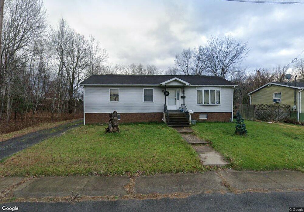
227 Oak St Taylor, PA 18517
Estimated Value: $83,282 - $290,000
Studio
--
Bath
--
Sq Ft
7,667
Sq Ft Lot
About This Home
This home is located at 227 Oak St, Taylor, PA 18517 and is currently estimated at $212,321. 227 Oak St is a home located in Lackawanna County with nearby schools including Riverside Junior/Senior High School, All Saints Academy, and Triboro Christian Academy.
Ownership History
Date
Name
Owned For
Owner Type
Purchase Details
Closed on
May 19, 2022
Sold by
Marturano Stephen T
Bought by
Marturano Stephen T
Current Estimated Value
Home Financials for this Owner
Home Financials are based on the most recent Mortgage that was taken out on this home.
Original Mortgage
$73,150
Outstanding Balance
$69,491
Interest Rate
5.25%
Mortgage Type
New Conventional
Estimated Equity
$142,830
Purchase Details
Closed on
May 5, 1988
Bought by
Martuarano Salvatore and Martuarano Cynthia
Create a Home Valuation Report for This Property
The Home Valuation Report is an in-depth analysis detailing your home's value as well as a comparison with similar homes in the area
Home Values in the Area
Average Home Value in this Area
Purchase History
| Date | Buyer | Sale Price | Title Company |
|---|---|---|---|
| Marturano Stephen T | $77,000 | None Listed On Document | |
| Martuarano Salvatore | $59,000 | -- |
Source: Public Records
Mortgage History
| Date | Status | Borrower | Loan Amount |
|---|---|---|---|
| Open | Marturano Stephen T | $73,150 |
Source: Public Records
Tax History
| Year | Tax Paid | Tax Assessment Tax Assessment Total Assessment is a certain percentage of the fair market value that is determined by local assessors to be the total taxable value of land and additions on the property. | Land | Improvement |
|---|---|---|---|---|
| 2025 | $3,254 | $13,500 | $2,000 | $11,500 |
| 2024 | $2,902 | $13,500 | $2,000 | $11,500 |
| 2023 | $2,902 | $13,500 | $2,000 | $11,500 |
| 2022 | $2,902 | $13,500 | $2,000 | $11,500 |
| 2021 | $2,902 | $13,500 | $2,000 | $11,500 |
| 2020 | $2,845 | $13,500 | $2,000 | $11,500 |
| 2019 | $2,710 | $13,500 | $2,000 | $11,500 |
| 2018 | $2,662 | $13,500 | $2,000 | $11,500 |
| 2017 | $2,586 | $13,500 | $2,000 | $11,500 |
| 2016 | $1,383 | $13,500 | $2,000 | $11,500 |
| 2015 | -- | $13,500 | $2,000 | $11,500 |
| 2014 | -- | $13,500 | $2,000 | $11,500 |
Source: Public Records
Map
Nearby Homes
- 0 Oak St Unit GSBSC255768
- 531 Oak St
- 736 Oak St
- LOT#16 Reynolds Ave
- Lot# 7 Reynolds Ave
- 118 N Main St
- 1227 Rundle St
- 343 Haverford Dr
- 2932 Penman St
- 115 W High St
- 1335 Sloan St
- 1301 Sloan St
- 1125 Watson St
- 0 William St Unit GSBSC253642
- 208 W Taylor St
- 112 E Grove St Unit 114
- Parcel B Davis Ct
- 3102 Grimes Ave
- 3214 Vipond Ave
- 107 Donny Dr
Your Personal Tour Guide
Ask me questions while you tour the home.