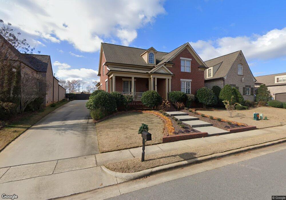
22760 Winged Foot Ln Athens, AL 35613
Estimated Value: $527,000 - $553,000
--
Bed
--
Bath
2,662
Sq Ft
$204/Sq Ft
Est. Value
About This Home
This home is located at 22760 Winged Foot Ln, Athens, AL 35613 and is currently estimated at $544,072, approximately $204 per square foot. 22760 Winged Foot Ln is a home with nearby schools including Brookhill Elementary School, Athens Intermediate School, and Athens Middle School.
Ownership History
Date
Name
Owned For
Owner Type
Purchase Details
Closed on
Feb 10, 2021
Sold by
Brown Kenneth and Brown Connie
Bought by
Brown Kenneth H and Brown Family Revocable Living
Current Estimated Value
Purchase Details
Closed on
Sep 17, 2008
Sold by
Jimmy Bryan Llc
Bought by
Brown Kenneth and Brown Connie
Home Financials for this Owner
Home Financials are based on the most recent Mortgage that was taken out on this home.
Original Mortgage
$276,000
Interest Rate
6.45%
Mortgage Type
Commercial
Create a Home Valuation Report for This Property
The Home Valuation Report is an in-depth analysis detailing your home's value as well as a comparison with similar homes in the area
Home Values in the Area
Average Home Value in this Area
Purchase History
| Date | Buyer | Sale Price | Title Company |
|---|---|---|---|
| Brown Kenneth H | -- | None Available | |
| Brown Kenneth | $345,000 | -- |
Source: Public Records
Mortgage History
| Date | Status | Borrower | Loan Amount |
|---|---|---|---|
| Previous Owner | Brown Kenneth | $276,000 |
Source: Public Records
Tax History Compared to Growth
Tax History
| Year | Tax Paid | Tax Assessment Tax Assessment Total Assessment is a certain percentage of the fair market value that is determined by local assessors to be the total taxable value of land and additions on the property. | Land | Improvement |
|---|---|---|---|---|
| 2024 | $1,521 | $49,960 | $0 | $0 |
| 2023 | $1,556 | $48,080 | $0 | $0 |
| 2022 | $1,278 | $38,960 | $0 | $0 |
| 2021 | $1,336 | $34,720 | $0 | $0 |
| 2020 | $1,259 | $32,800 | $0 | $0 |
| 2019 | $1,272 | $33,120 | $0 | $0 |
| 2018 | $1,342 | $34,880 | $0 | $0 |
| 2017 | $1,342 | $34,880 | $0 | $0 |
| 2016 | $1,342 | $348,800 | $0 | $0 |
| 2015 | $1,342 | $34,880 | $0 | $0 |
| 2014 | $1,319 | $0 | $0 | $0 |
Source: Public Records
Map
Nearby Homes
- 22470 Westminster Dr
- 22462 Westminster Dr
- 23094 Piney Creek Dr
- 23310 Piney Creek Dr
- 22450 Westminster Dr
- 23046 Piney Creek Dr
- 23007 Cog Hill Dr
- 23363 Piney Creek Dr
- 22977 Cog Hill Dr
- 14209 Muirfield Dr
- 22392 Westminster Dr
- 22640 Regent Dr
- 14566 London Ln
- 14511 London Ln
- 23567 Piney Creek Dr
- 14318 Muirfield Dr
- 14783 London Ln
- 22910 Regent Dr
- 14359 Muirfield Dr
- 22656 Riviera Dr
- 22746 Winged Foot Ln
- 22736 Winged Foot Ln
- 22766 Winged Foot Ln
- 22813 Baltusrol Ln
- 22777 Baltusrol Ln
- 22813 Baltustrol Ln
- 22772 Winged Foot Ln
- 22853 Baltusrol Ln
- 22902 Baltustrol Ln
- 22835 Baltusrol Ln
- 22722 Winged Foot Ln
- 22777 Baltustrol Ln
- 22784 Baltustrol Ln
- 22859 Baltustrol Ln
- 22859 Baltusrol Ln
- 22700 Winged Foot Ln
- 22820 Baltusrol Ln
- 0 Baltusrol Ln Unit 317964
- 0 Baltusrol Ln Unit 1826604
- 0 Baltusrol Ln Unit 315308