Estimated Value: $544,731 - $626,000
4
Beds
3
Baths
2,103
Sq Ft
$271/Sq Ft
Est. Value
About This Home
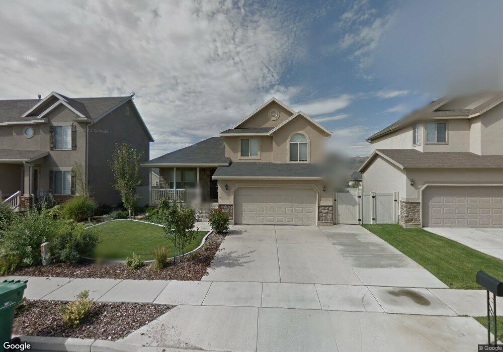
This home is located at 2279 N 2400 W, Lehi, UT 84043 and is currently estimated at $569,933, approximately $271 per square foot. 2279 N 2400 W is a home located in Utah County with nearby schools including Liberty Hills Elementary School, Skyridge High School, and Ascent Academies of Utah - Lehi Campus.
Ownership History
Date
Name
Owned For
Owner Type
Purchase Details
Closed on
Dec 28, 2022
Sold by
Boarden Korinn
Bought by
Paredes Antonio Campos and Ediae-Paredes Marcelina Osariyekemwe
Current Estimated Value
Home Financials for this Owner
Home Financials are based on the most recent Mortgage that was taken out on this home.
Original Mortgage
$482,125
Outstanding Balance
$467,160
Interest Rate
6.58%
Mortgage Type
New Conventional
Estimated Equity
$102,773
Purchase Details
Closed on
Mar 5, 2018
Sold by
Boarden Zachary and Boarden Korinn
Bought by
Boardebn Korinn
Purchase Details
Closed on
Nov 10, 2014
Sold by
Verwer Brian L and Verwer Patricia K
Bought by
Boarden Zachary and Boarden Korinn
Home Financials for this Owner
Home Financials are based on the most recent Mortgage that was taken out on this home.
Original Mortgage
$207,900
Interest Rate
4.16%
Mortgage Type
New Conventional
Create a Home Valuation Report for This Property
The Home Valuation Report is an in-depth analysis detailing your home's value as well as a comparison with similar homes in the area
Home Values in the Area
Average Home Value in this Area
Purchase History
| Date | Buyer | Sale Price | Title Company |
|---|---|---|---|
| Paredes Antonio Campos | -- | First American Title | |
| Boardebn Korinn | -- | Vanguard Title Ins Agency Ll | |
| Boarden Zachary | -- | Meridian Title Co |
Source: Public Records
Mortgage History
| Date | Status | Borrower | Loan Amount |
|---|---|---|---|
| Open | Paredes Antonio Campos | $482,125 | |
| Previous Owner | Boarden Zachary | $207,900 |
Source: Public Records
Tax History Compared to Growth
Tax History
| Year | Tax Paid | Tax Assessment Tax Assessment Total Assessment is a certain percentage of the fair market value that is determined by local assessors to be the total taxable value of land and additions on the property. | Land | Improvement |
|---|---|---|---|---|
| 2025 | $2,197 | $270,160 | $202,800 | $288,400 |
| 2024 | $2,197 | $257,070 | $0 | $0 |
| 2023 | $2,082 | $264,550 | $0 | $0 |
| 2022 | $2,219 | $273,295 | $0 | $0 |
| 2021 | $1,983 | $369,300 | $117,400 | $251,900 |
| 2020 | $1,869 | $344,100 | $108,700 | $235,400 |
| 2019 | $1,709 | $327,000 | $108,700 | $218,300 |
| 2018 | $1,671 | $302,300 | $102,500 | $199,800 |
| 2017 | $1,590 | $152,900 | $0 | $0 |
| 2016 | $1,618 | $144,375 | $0 | $0 |
| 2015 | $1,502 | $127,215 | $0 | $0 |
| 2014 | $1,395 | $117,480 | $0 | $0 |
Source: Public Records
Map
Nearby Homes
- 2464 W 2250 N
- 2196 N 2350 W
- 2189 N 2600 W
- 1968 N 2040 W Unit 40
- 1990 N 2040 W
- 1990 N 2040 W Unit 41
- Huntington Plan at Pioneer Meadows
- Silver Lake Plan at Pioneer Meadows
- Summit Plan at Pioneer Meadows
- Palisade Plan at Pioneer Meadows
- 1970 N 2090 St W
- 1912 W 2250 N
- 1854 N 2230 W
- 1898 W Pointe Meadow Loop
- 1842 N 2230 W
- 1870 N 2230 W
- 1870 N 2230 W Unit 23
- 1896 N 2230 W
- 1908 N 2230 W
- 1832 N 2230 W