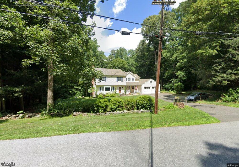
228 Branch Brook Rd Wilton, CT 06897
Estimated Value: $1,214,000 - $1,409,000
4
Beds
4
Baths
3,070
Sq Ft
$422/Sq Ft
Est. Value
About This Home
This home is located at 228 Branch Brook Rd, Wilton, CT 06897 and is currently estimated at $1,294,367, approximately $421 per square foot. 228 Branch Brook Rd is a home located in Fairfield County with nearby schools including Miller-Driscoll School, Cider Mill School, and Middlebrook School.
Ownership History
Date
Name
Owned For
Owner Type
Purchase Details
Closed on
May 6, 2025
Sold by
Lee Peter S and Lee Shirley P
Bought by
Lee Lt
Current Estimated Value
Purchase Details
Closed on
Jun 23, 1994
Sold by
Mewing Ed and Mewing Dorothy
Bought by
Lee Peter and Lee Shirley
Create a Home Valuation Report for This Property
The Home Valuation Report is an in-depth analysis detailing your home's value as well as a comparison with similar homes in the area
Home Values in the Area
Average Home Value in this Area
Purchase History
| Date | Buyer | Sale Price | Title Company |
|---|---|---|---|
| Lee Lt | -- | None Available | |
| Lee Lt | -- | None Available | |
| Lee Peter | $350,000 | -- | |
| Lee Peter | $350,000 | -- |
Source: Public Records
Mortgage History
| Date | Status | Borrower | Loan Amount |
|---|---|---|---|
| Previous Owner | Lee Peter | $395,000 | |
| Previous Owner | Lee Peter | $105,000 | |
| Previous Owner | Lee Peter | $92,000 |
Source: Public Records
Tax History Compared to Growth
Tax History
| Year | Tax Paid | Tax Assessment Tax Assessment Total Assessment is a certain percentage of the fair market value that is determined by local assessors to be the total taxable value of land and additions on the property. | Land | Improvement |
|---|---|---|---|---|
| 2025 | $16,089 | $659,120 | $306,110 | $353,010 |
| 2024 | $15,779 | $659,120 | $306,110 | $353,010 |
| 2023 | $14,294 | $488,530 | $292,740 | $195,790 |
| 2022 | $13,791 | $488,530 | $292,740 | $195,790 |
| 2021 | $7,806 | $488,530 | $292,740 | $195,790 |
| 2020 | $7,618 | $488,530 | $292,740 | $195,790 |
| 2019 | $13,943 | $488,530 | $292,740 | $195,790 |
| 2018 | $7,626 | $510,440 | $308,000 | $202,440 |
| 2017 | $14,002 | $504,210 | $308,000 | $196,210 |
| 2016 | $13,785 | $504,210 | $308,000 | $196,210 |
| 2015 | $13,528 | $504,210 | $308,000 | $196,210 |
| 2014 | $13,367 | $504,210 | $308,000 | $196,210 |
Source: Public Records
Map
Nearby Homes
- 38 Honey Hill Rd
- 35 Branch Brook Rd
- 175 Mountain Rd
- 13 Indian Hill Rd
- 00 Old Mill Rd
- 33 Cannon Rd
- 25 Samuelson Rd
- 0 Old Mill Rd
- 112 Middlebrook Farm Rd
- 23 Wilson Rd
- 54 Mountain Rd
- 30 Black Alder Ln
- 96 Georgetown Rd
- 12 Upper Parish Dr
- 0 Mountain Rd
- 20 Georgetown Rd
- 9 Read Place
- 330 Ridgefield Rd
- 55 Tanners Dr
- 33 Middlebrook Farm Rd
- 234 Branch Brook Rd
- 3 Saint Johns Rd
- 220 Branch Brook Rd
- 10 Saint Johns Rd
- 242 Branch Brook Rd
- 14 Saint Johns Rd
- 125 Chicken St
- 226 Branch Brook Rd
- 252 Branch Brook Rd
- 222 Branch Brook Rd
- 19 Saint Johns Rd
- 122 Chicken St
- 115 Chicken St
- 155 Hulda Hill Rd
- 219 Branch Brook Rd
- 25 Boulder Brook Rd
- 224 Branch Brook Rd
- 28 Saint Johns Rd
- 116 Chicken St
- 386 Mountain Rd