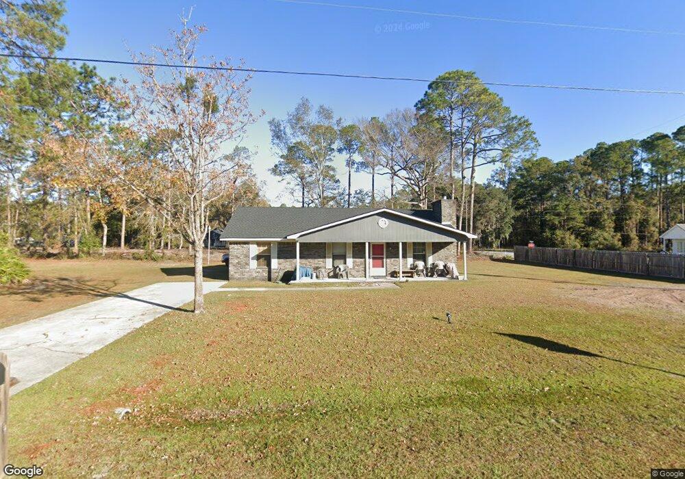
228 Pamela Dr Allenhurst, GA 31301
Estimated Value: $212,000 - $264,000
3
Beds
2
Baths
1,455
Sq Ft
$161/Sq Ft
Est. Value
About This Home
This home is located at 228 Pamela Dr, Allenhurst, GA 31301 and is currently estimated at $233,943, approximately $160 per square foot. 228 Pamela Dr is a home located in Liberty County with nearby schools including Frank Long Elementary School, Lewis Frasier Middle School, and Liberty County High School.
Ownership History
Date
Name
Owned For
Owner Type
Purchase Details
Closed on
Nov 30, 1999
Sold by
Sec Of V A
Bought by
Madden Dagmar
Current Estimated Value
Purchase Details
Closed on
Oct 6, 1998
Sold by
Varney Kenneth R and Varney C
Bought by
Sec Of V A
Purchase Details
Closed on
May 2, 1994
Bought by
Varney Kenneth R and Varney C
Purchase Details
Closed on
Feb 16, 1994
Bought by
Keith Dykes
Purchase Details
Closed on
Aug 2, 1993
Bought by
Bacon Gary
Create a Home Valuation Report for This Property
The Home Valuation Report is an in-depth analysis detailing your home's value as well as a comparison with similar homes in the area
Home Values in the Area
Average Home Value in this Area
Purchase History
| Date | Buyer | Sale Price | Title Company |
|---|---|---|---|
| Madden Dagmar | $47,200 | -- | |
| Sec Of V A | -- | -- | |
| Source One Mtg | $51,600 | -- | |
| Varney Kenneth R | $64,900 | -- | |
| Keith Dykes | -- | -- | |
| Bacon Gary | -- | -- |
Source: Public Records
Tax History
| Year | Tax Paid | Tax Assessment Tax Assessment Total Assessment is a certain percentage of the fair market value that is determined by local assessors to be the total taxable value of land and additions on the property. | Land | Improvement |
|---|---|---|---|---|
| 2024 | $4,104 | $66,324 | $12,000 | $54,324 |
| 2023 | $2,748 | $60,394 | $12,000 | $48,394 |
| 2022 | $1,826 | $47,045 | $12,000 | $35,045 |
| 2021 | $1,663 | $42,968 | $12,000 | $30,968 |
| 2020 | $1,550 | $39,882 | $10,000 | $29,882 |
| 2019 | $1,525 | $40,270 | $10,000 | $30,270 |
| 2018 | $1,464 | $39,125 | $10,000 | $29,125 |
| 2017 | $1,676 | $39,494 | $10,000 | $29,494 |
| 2016 | $1,443 | $41,434 | $10,000 | $31,434 |
| 2015 | $1,519 | $41,434 | $10,000 | $31,434 |
| 2014 | $1,519 | $43,186 | $10,000 | $33,186 |
| 2013 | -- | $34,448 | $4,000 | $30,448 |
Source: Public Records
Map
Nearby Homes
- 155 Jefferson Cir SE
- 143 Morningside Dr
- 129 Vandiver Rd
- 304 Thompson Rd
- 667 Godfrey Rd
- 1343 Talmadge Rd
- 1338 Talmadge Rd
- 127 Busbee Rd
- 169 Wellspring Terrace
- 27 Zoe Ln
- 353 Wilder Rd
- 28 Beaumont Dr
- 34 Beaumont Dr
- 619 Mccumber Dr
- 859 Hunters Ln SE
- 856 Hunters Ln SE
- 151 Hunters Branch Dr
- 0 & 1 Denise Ln
- 480 Mccumber Dr
- 337 Boundary Hall Way
- 204 Pamela Dr
- 409 Carter Rd Unit 1 A&B
- 409 Carter Rd Unit Property 1 A&B
- 227 Pamela Dr
- 205 Pamela Dr
- 781 Talmadge Rd Unit Property 1 unit 1
- 781 Talmadge Rd Unit 2
- 781 Talmadge Rd Unit 3
- 781 Talmadge Rd Unit 1
- 781 Talmadge Rd Unit Duplex 3 Unit 2
- 781 Talmadge Rd Unit Duplex 3 unit 1
- 781 Talmadge Rd Unit Duplex 2 Unit 2
- 781 Talmadge Rd Unit Duplex 2 unit 1
- 781 Talmadge Rd Unit Duplex 1 Unit 2
- 781 Talmadge Rd Unit Duplex 1 Unit 1
- 781 Talmadge Rd
- 178 Pamela Dr
- 305 Carter Rd
- 13 Gregory Ct
- 175 Pamela Dr Unit n/a
Your Personal Tour Guide
Ask me questions while you tour the home.