Estimated Value: $397,530 - $427,000
4
Beds
2
Baths
1,620
Sq Ft
$257/Sq Ft
Est. Value
About This Home
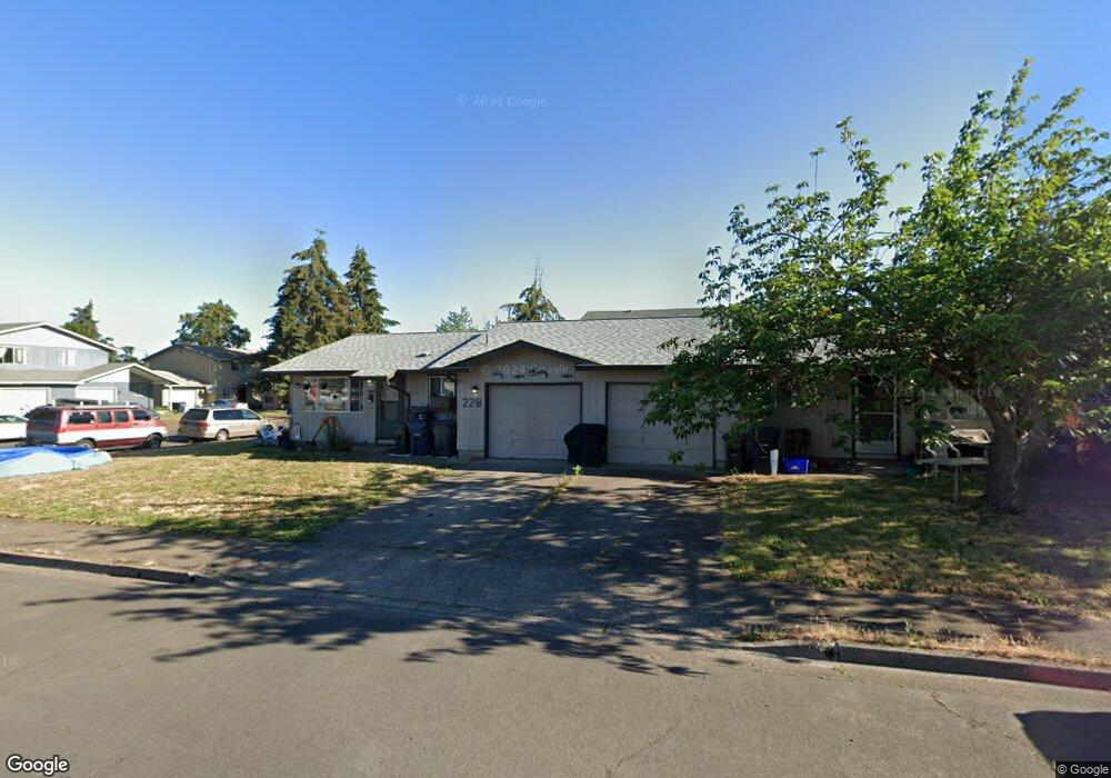
This home is located at 228 U St, Springfield, OR 97477 and is currently estimated at $416,883, approximately $257 per square foot. 228 U St is a home located in Lane County with nearby schools including Elizabeth Page Elementary School, Hamlin Middle School, and Springfield High School.
Ownership History
Date
Name
Owned For
Owner Type
Purchase Details
Closed on
May 11, 2005
Sold by
Johnson Rebecca
Bought by
Graton Kenneth W and Graton Lisa A
Current Estimated Value
Home Financials for this Owner
Home Financials are based on the most recent Mortgage that was taken out on this home.
Original Mortgage
$132,000
Outstanding Balance
$68,730
Interest Rate
6.02%
Mortgage Type
Fannie Mae Freddie Mac
Estimated Equity
$348,153
Purchase Details
Closed on
Sep 14, 2001
Sold by
Vigeland Christopher Bryan
Bought by
Johnson Rebecca
Home Financials for this Owner
Home Financials are based on the most recent Mortgage that was taken out on this home.
Original Mortgage
$97,600
Interest Rate
6.99%
Create a Home Valuation Report for This Property
The Home Valuation Report is an in-depth analysis detailing your home's value as well as a comparison with similar homes in the area
Home Values in the Area
Average Home Value in this Area
Purchase History
| Date | Buyer | Sale Price | Title Company |
|---|---|---|---|
| Graton Kenneth W | $165,000 | Fidelity National Title Insu | |
| Johnson Rebecca | $122,000 | Western Title & Escrow Compa |
Source: Public Records
Mortgage History
| Date | Status | Borrower | Loan Amount |
|---|---|---|---|
| Open | Graton Kenneth W | $132,000 | |
| Previous Owner | Johnson Rebecca | $97,600 |
Source: Public Records
Tax History
| Year | Tax Paid | Tax Assessment Tax Assessment Total Assessment is a certain percentage of the fair market value that is determined by local assessors to be the total taxable value of land and additions on the property. | Land | Improvement |
|---|---|---|---|---|
| 2025 | $3,546 | $193,390 | -- | -- |
| 2024 | $3,489 | $187,758 | -- | -- |
| 2023 | $3,489 | $182,290 | $0 | $0 |
| 2022 | $3,231 | $176,981 | $0 | $0 |
| 2021 | $3,173 | $171,827 | $0 | $0 |
| 2020 | $3,081 | $166,823 | $0 | $0 |
| 2019 | $2,988 | $161,965 | $0 | $0 |
| 2018 | $2,817 | $152,668 | $0 | $0 |
| 2017 | $2,708 | $152,668 | $0 | $0 |
| 2016 | $2,652 | $148,221 | $0 | $0 |
| 2015 | $2,558 | $143,904 | $0 | $0 |
| 2014 | $2,499 | $139,713 | $0 | $0 |
Source: Public Records
Map
Nearby Homes
- 421 Woodlane Dr
- 2240 5th St
- 77 Shady Loop
- 126 Woodlane Dr
- 2318 N 8th St
- 212 Hayden Bridge Way
- 2136 8th St
- 2268 9th St
- 40 Allen Ave
- 817 River Knoll Way
- 780 Q St
- 2150 Laura St Unit 119
- 2150 Laura St Unit 111
- 2150 Laura St Unit 39
- 2150 Laura St Unit 57
- 2150 Laura St Unit 83
- 2150 Laura St Unit 44
- 2150 Laura (#57) St Unit 57
- 970 T St
- 937 S St
Your Personal Tour Guide
Ask me questions while you tour the home.