
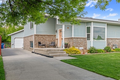
228 W 470 S American Fork, UT 84003
Estimated payment $2,436/month
Highlights
- Updated Kitchen
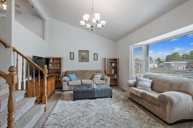
- Vaulted Ceiling
- Den
- Mountain View
- No HOA
- Cul-De-Sac
About This Home
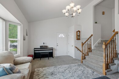
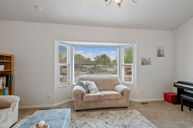
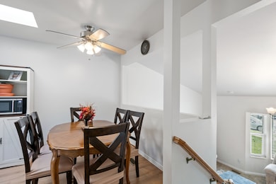
Don't miss this beautifully maintained twin home nestled on a quiet dead-end street. This home offers an oversized two-car garage, two spacious family rooms, vaulted ceilings, generous storage space, a bright walkout basement, and a charming garden space with raspberries, strawberries, and blackberries. You'll love the abundance of natural light streaming through south-facing windows and a skylight, creating a warm and inviting atmosphere throughout. Recent updates include a brand new roof, new vinyl windows, durable vinyl flooring, modern kitchen cabinets, and elegant quartz countertops. Ideally located with quick access to I-15 and American Fork Main Street, and just minutes from the American Fork Trax Station, Costco, Target, Home Depot, and a wide variety of dining and shopping options. Experience the best of both worlds: peaceful living in a secluded community with all the conveniences you need just moments away. Schedule your showing today!
Listing Agent
Samuel Brinton
REDFIN CORPORATION License #11804653 Listed on: 11/18/2025

Townhouse Details
Home Type
- Townhome
Est. Annual Taxes
- $1,868
Year Built
- Built in 1995
Lot Details
- 4,792 Sq Ft Lot
- Cul-De-Sac
- Partially Fenced Property
- Landscaped
- Sprinkler System
- Vegetable Garden
Parking
- 2 Car Garage
- Open Parking
Home Design
- Twin Home
- Brick Exterior Construction
Interior Spaces
- 1,742 Sq Ft Home
- 2-Story Property
- Vaulted Ceiling
- Ceiling Fan
- Skylights
- Double Pane Windows
- Blinds
- Den
- Mountain Views
- Smart Thermostat
- Electric Dryer Hookup
Kitchen
- Updated Kitchen
- Free-Standing Range
- Range Hood
- Disposal
Flooring
- Carpet
- Tile
Bedrooms and Bathrooms
- 3 Bedrooms | 2 Main Level Bedrooms
- Primary Bedroom located in the basement
Basement
- Walk-Out Basement
- Exterior Basement Entry
Outdoor Features
- Outbuilding
- Playground
- Play Equipment
- Porch
Schools
- Greenwood Elementary School
- American Fork Middle School
- American Fork High School
Utilities
- Forced Air Heating and Cooling System
- Natural Gas Connected
Community Details
- No Home Owners Association
Listing and Financial Details
- Exclusions: Dryer, Microwave, Washer
- Assessor Parcel Number 34-242-0301
Map
Home Values in the Area
Average Home Value in this Area
Tax History
| Year | Tax Paid | Tax Assessment Tax Assessment Total Assessment is a certain percentage of the fair market value that is determined by local assessors to be the total taxable value of land and additions on the property. | Land | Improvement |
|---|---|---|---|---|
| 2025 | $1,868 | $210,925 | $99,800 | $283,700 |
| 2024 | $1,868 | $207,570 | $0 | $0 |
| 2023 | $1,727 | $203,445 | $0 | $0 |
| 2022 | $1,582 | $183,920 | $0 | $0 |
| 2021 | $1,416 | $257,200 | $83,600 | $173,600 |
| 2020 | $1,378 | $242,600 | $83,600 | $159,000 |
| 2019 | $1,235 | $225,000 | $83,600 | $141,400 |
| 2018 | $1,202 | $209,400 | $83,600 | $125,800 |
| 2017 | $1,197 | $112,475 | $0 | $0 |
| 2016 | $1,016 | $88,715 | $0 | $0 |
| 2015 | $1,035 | $85,800 | $0 | $0 |
| 2014 | $954 | $77,990 | $0 | $0 |
Property History
| Date | Event | Price | List to Sale | Price per Sq Ft |
|---|---|---|---|---|
| 11/18/2025 11/18/25 | For Sale | $433,000 | -- | $249 / Sq Ft |
Purchase History
| Date | Type | Sale Price | Title Company |
|---|---|---|---|
| Warranty Deed | -- | First American Title | |
| Warranty Deed | -- | Sundance Title Insurance Ag | |
| Warranty Deed | -- | -- |
Mortgage History
| Date | Status | Loan Amount | Loan Type |
|---|---|---|---|
| Open | $188,000 | New Conventional | |
| Previous Owner | $120,550 | No Value Available | |
| Previous Owner | $104,192 | FHA |
Source: UtahRealEstate.com
MLS Number: 2123355
APN: 34-242-0301
Disclaimer: Certain information contained herein is derived from information provided by parties other than Homes.com. All information provided is deemed reliable, but is not guaranteed to be accurate and should be independently verified.
![]() IDX information is provided exclusively for consumers’ personal, non-commercial use, that it may not be used for any purpose other than to identify prospective properties consumers may be interested in purchasing, and that the data is deemed reliable but is not guaranteed accurate by the MLS. Licensor is only providing the MLS Content and not other sources of data provided in the Product.
IDX information is provided exclusively for consumers’ personal, non-commercial use, that it may not be used for any purpose other than to identify prospective properties consumers may be interested in purchasing, and that the data is deemed reliable but is not guaranteed accurate by the MLS. Licensor is only providing the MLS Content and not other sources of data provided in the Product.
Based on information from the Wasatch Front Regional Multiple Listing Service, Inc.. All data, including all measurements and calculations of area, is obtained from various sources and has not been, and will not be, verified by broker or the MLS. All information should be independently reviewed and verified for accuracy. Properties may or may not be listed by the office/agent presenting the information.
- 429 S Storrs Ave
- Evergreen Plan at Storrs Court
- Juniper Plan at Storrs Court
- Redwood Plan at Storrs Court
- Ashwood Plan at Storrs Court
- 316 W 390 S
- 424 S 340 W
- 365 W 370 S
- 382 W 330 S
- 271 S Barratt Cir
- 65 E 400 S Unit 8
- 499 S 800 W
- 195 S Center St
- 417 W 800 S
- 351 Washington Ave
- 82 S Lincoln Ave
- 55 S 200 W
- 894 S 370 W
- 455 S 680 W
- 415 S 680 W Unit 45
- 465 S 100 E St
- 439 S Meadow Garden Rd
- 751 W 200 S
- 412 S Willow Leaf Rd
- 299 S 850 W
- 1055 W 550 S Unit ID1249864P
- 301 S 1100 W
- 688 W Nicholes Ln
- 1107 W 250 S
- 57 N 900 W
- 642 E 460 S Unit ID1249867P
- 383 S 650 E
- 383 S 650 E Unit 162
- 408 S 680 E Unit ID1249845P
- 682 E 480 S Unit ID1250635P
- 302 S 740 E
- 79 N 1020 W
- 742 E 620 S
- 860 E 400 S
- 800 E 620 St