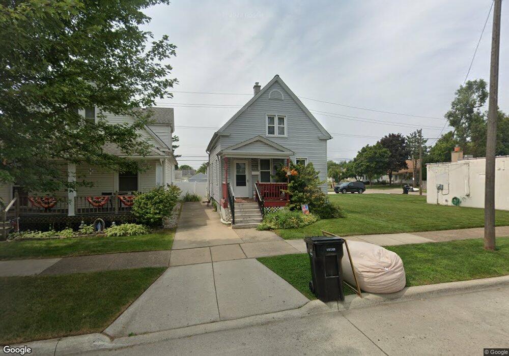
2282 10th St Wyandotte, MI 48192
Estimated Value: $149,307 - $192,000
--
Bed
--
Bath
939
Sq Ft
$173/Sq Ft
Est. Value
About This Home
This home is located at 2282 10th St, Wyandotte, MI 48192 and is currently estimated at $162,077, approximately $172 per square foot. 2282 10th St is a home located in Wayne County with nearby schools including Washington Elementary School, Woodrow Wilson School, and Roosevelt High School.
Ownership History
Date
Name
Owned For
Owner Type
Purchase Details
Closed on
Apr 2, 2021
Sold by
Kiss Barbara
Bought by
Kiss Barbara and Kiss Elizabeth A
Current Estimated Value
Purchase Details
Closed on
Nov 15, 2018
Sold by
Johnson Sheila M and Swarski Sheila M
Bought by
Hayslip Cashero Sarah
Home Financials for this Owner
Home Financials are based on the most recent Mortgage that was taken out on this home.
Original Mortgage
$109,500
Interest Rate
4.9%
Mortgage Type
New Conventional
Purchase Details
Closed on
Apr 15, 1997
Sold by
Anna Sherman Estate & De
Bought by
Sheila M Siwarski
Create a Home Valuation Report for This Property
The Home Valuation Report is an in-depth analysis detailing your home's value as well as a comparison with similar homes in the area
Home Values in the Area
Average Home Value in this Area
Purchase History
| Date | Buyer | Sale Price | Title Company |
|---|---|---|---|
| Kiss Barbara | -- | None Available | |
| Kiss Barbara | $115,000 | Capital Title Ins Agcy Inc | |
| Hayslip Cashero Sarah | $110,000 | None Available | |
| Sheila M Siwarski | $39,900 | -- |
Source: Public Records
Mortgage History
| Date | Status | Borrower | Loan Amount |
|---|---|---|---|
| Previous Owner | Hayslip Cashero Sarah | $109,500 |
Source: Public Records
Tax History Compared to Growth
Tax History
| Year | Tax Paid | Tax Assessment Tax Assessment Total Assessment is a certain percentage of the fair market value that is determined by local assessors to be the total taxable value of land and additions on the property. | Land | Improvement |
|---|---|---|---|---|
| 2025 | $2,622 | $65,700 | $0 | $0 |
| 2024 | $2,622 | $64,400 | $0 | $0 |
| 2023 | $2,500 | $59,600 | $0 | $0 |
| 2022 | $2,918 | $53,700 | $0 | $0 |
| 2021 | $2,161 | $49,400 | $0 | $0 |
| 2020 | $2,131 | $44,300 | $0 | $0 |
| 2019 | $2,101 | $38,300 | $0 | $0 |
| 2018 | $1,043 | $27,600 | $0 | $0 |
| 2017 | $457 | $27,600 | $0 | $0 |
| 2016 | $1,261 | $25,600 | $0 | $0 |
| 2015 | $2,250 | $23,800 | $0 | $0 |
| 2013 | $2,180 | $21,800 | $0 | $0 |
| 2012 | $1,014 | $22,800 | $5,100 | $17,700 |
Source: Public Records
Map
Nearby Homes
- 2268 10th St
- 2286 10th St
- 1031 Mulberry St
- 2300 10th St
- 1039 Mulberry St
- 2308 10th St
- 1028 Mollno St
- 1045 Mulberry St
- 2283 10th St
- 2287 10th St
- 2263 10th St
- 1034 Mollno St Unit Bldg-Unit
- 1034 Mollno St
- 2316 10th St
- 2271 10th St
- 2301 10th - Upper St
- 2301 10th St
- 1040 Mollno St
- 2251 10th St
- 2250 10th St