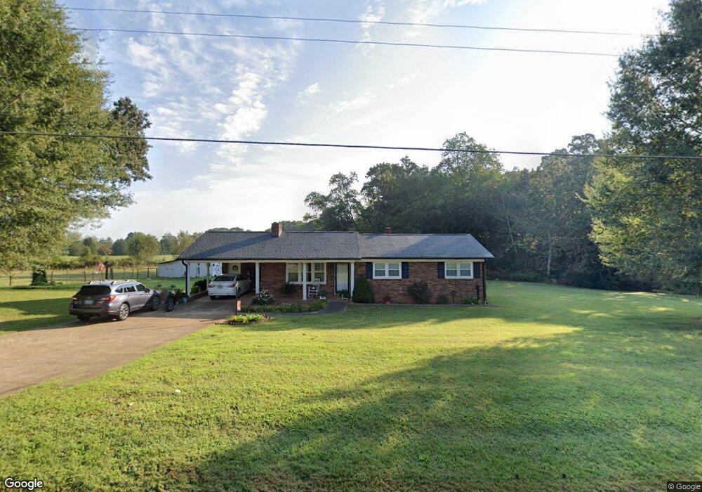
2289 Shoal Rd Crouse, NC 28033
Estimated Value: $247,030 - $342,000
3
Beds
2
Baths
1,184
Sq Ft
$261/Sq Ft
Est. Value
About This Home
This home is located at 2289 Shoal Rd, Crouse, NC 28033 and is currently estimated at $309,008, approximately $260 per square foot. 2289 Shoal Rd is a home located in Lincoln County with nearby schools including Norris S. Childers Elementary School, West Lincoln Middle, and West Lincoln High School.
Ownership History
Date
Name
Owned For
Owner Type
Purchase Details
Closed on
Nov 30, 2015
Sold by
Huss Billie A
Bought by
Huss Marty D and Huss Billie A
Current Estimated Value
Home Financials for this Owner
Home Financials are based on the most recent Mortgage that was taken out on this home.
Original Mortgage
$151,022
Interest Rate
3.83%
Mortgage Type
Purchase Money Mortgage
Create a Home Valuation Report for This Property
The Home Valuation Report is an in-depth analysis detailing your home's value as well as a comparison with similar homes in the area
Purchase History
| Date | Buyer | Sale Price | Title Company |
|---|---|---|---|
| Huss Marty D | -- | None Available |
Source: Public Records
Mortgage History
| Date | Status | Borrower | Loan Amount |
|---|---|---|---|
| Closed | Huss Marty D | $151,022 |
Source: Public Records
Tax History
| Year | Tax Paid | Tax Assessment Tax Assessment Total Assessment is a certain percentage of the fair market value that is determined by local assessors to be the total taxable value of land and additions on the property. | Land | Improvement |
|---|---|---|---|---|
| 2025 | $1,283 | $186,222 | $32,777 | $153,445 |
| 2024 | $1,263 | $186,222 | $32,777 | $153,445 |
| 2023 | $1,204 | $186,222 | $32,777 | $153,445 |
| 2022 | $953 | $118,809 | $23,137 | $95,672 |
| 2021 | $953 | $118,809 | $23,137 | $95,672 |
| 2020 | $873 | $118,809 | $23,137 | $95,672 |
| 2019 | $873 | $118,809 | $23,137 | $95,672 |
| 2018 | $815 | $97,301 | $21,613 | $75,688 |
| 2017 | $714 | $97,301 | $21,613 | $75,688 |
| 2016 | $714 | $97,301 | $21,613 | $75,688 |
| 2015 | $783 | $97,301 | $21,613 | $75,688 |
| 2014 | $816 | $104,350 | $22,685 | $81,665 |
Source: Public Records
Map
Nearby Homes
- 4660 Garys Place
- 0000 Garys Place
- 7124 Old Hickory Ln
- 5740 Crouse Rd
- 3051 Shoal Rd
- 1882 George Brown Rd
- 000 Leonards Fork Church Rd
- 58 Malden Ct
- 56 Malden Ct
- 57 Malden Ct
- 00 Malden Ct
- 453 Robert Rd
- 1357 Malden Ct
- 3635 Jennifer Ballenger Ln
- 148 Buck Fraley Rd
- 1000 Creekside Dr
- 3237 Evondale Rd
- 1353 Maple Lee Ct
- 1074 Lyndsey Brook Ct
- 00 Arrow St Unit 38
- 2286 Shoal Rd
- 19.3 Acres Shoal Rd
- 10.1 Acres Shoal Rd
- 14.5 Acres Shoal Rd
- 4023 Blair Rd
- 2216 Shoal Rd
- 2302 Shoal Rd
- 2321 Shoal Rd
- 2326 Shoal Rd
- 2194 Shoal Rd
- 2335 Shoal Rd
- 4670 Garys Place
- 4680 Garys Place
- 4706 Garys Place
- 4714 Garys Place
- 4640 Garys Place
- 4716 Garys Place
- 4671 Garys Place
- 2431 Lena Ann Ct
- 2430 Lena Ann Ct
Your Personal Tour Guide
Ask me questions while you tour the home.