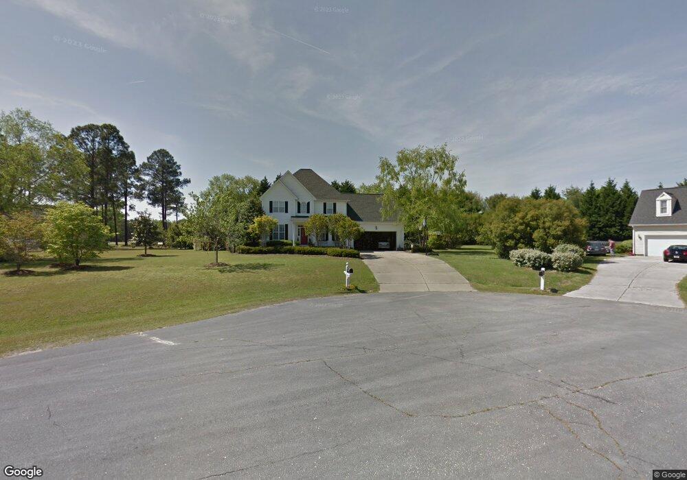
229 Ashton Ln Angier, NC 27501
Estimated Value: $365,601 - $460,000
3
Beds
3
Baths
2,234
Sq Ft
$183/Sq Ft
Est. Value
About This Home
This home is located at 229 Ashton Ln, Angier, NC 27501 and is currently estimated at $407,900, approximately $182 per square foot. 229 Ashton Ln is a home located in Harnett County with nearby schools including North Harnett Primary School, Angier Elementary School, and Harnett Central Middle School.
Ownership History
Date
Name
Owned For
Owner Type
Purchase Details
Closed on
Nov 28, 2018
Sold by
Mcclay Thomas C and Mcclay Ellen S
Bought by
Roberts Currin Rita Touchet and Roberts Currin Jr Millard
Current Estimated Value
Home Financials for this Owner
Home Financials are based on the most recent Mortgage that was taken out on this home.
Original Mortgage
$200,000
Outstanding Balance
$174,649
Interest Rate
4.37%
Mortgage Type
Adjustable Rate Mortgage/ARM
Estimated Equity
$233,251
Purchase Details
Closed on
Oct 18, 1996
Bought by
Mcclay Thomas C
Create a Home Valuation Report for This Property
The Home Valuation Report is an in-depth analysis detailing your home's value as well as a comparison with similar homes in the area
Home Values in the Area
Average Home Value in this Area
Purchase History
| Date | Buyer | Sale Price | Title Company |
|---|---|---|---|
| Roberts Currin Rita Touchet | $245,000 | None Available | |
| Mcclay Thomas C | $154,000 | -- |
Source: Public Records
Mortgage History
| Date | Status | Borrower | Loan Amount |
|---|---|---|---|
| Open | Roberts Currin Rita Touchet | $200,000 |
Source: Public Records
Tax History Compared to Growth
Tax History
| Year | Tax Paid | Tax Assessment Tax Assessment Total Assessment is a certain percentage of the fair market value that is determined by local assessors to be the total taxable value of land and additions on the property. | Land | Improvement |
|---|---|---|---|---|
| 2025 | $1,755 | $250,801 | $0 | $0 |
| 2024 | $1,780 | $250,801 | $0 | $0 |
| 2023 | $1,755 | $250,801 | $0 | $0 |
| 2022 | $1,760 | $250,801 | $0 | $0 |
| 2021 | $1,760 | $204,220 | $0 | $0 |
| 2020 | $1,760 | $204,220 | $0 | $0 |
| 2019 | $1,745 | $204,220 | $0 | $0 |
| 2018 | $1,745 | $204,220 | $0 | $0 |
| 2017 | $1,745 | $204,220 | $0 | $0 |
| 2016 | $1,879 | $220,650 | $0 | $0 |
| 2015 | $1,879 | $220,650 | $0 | $0 |
| 2014 | $1,879 | $220,650 | $0 | $0 |
Source: Public Records
Map
Nearby Homes
- 30 Wheat Dr
- 86 Ashcott Dr
- Elmhurst Plan at Honeycutt Hills
- Jordan Plan at Honeycutt Hills
- Drayton Plan at Honeycutt Hills
- Burton Plan at Honeycutt Hills
- Middleton Plan at Honeycutt Hills
- Townsend Plan at Honeycutt Hills
- Norris Plan at Honeycutt Hills
- Devon Plan at Honeycutt Hills
- Stonefield Plan at Honeycutt Hills
- 56 Shelby Meadow Ln
- Avery Plan at Atherstone
- Rolen Plan at Atherstone
- Cary Plan at Atherstone
- Camden Plan at Atherstone
- Blanco Plan at Atherstone
- Birch Plan at Atherstone
- Aaron Plan at Atherstone
- 228 Shelby Meadow Ln
- 41 Pine Croft Rd
- 239 Ashton Ln
- 207 Ashton Ln
- 207 Ashton Ln
- 6094 Nc 210 N
- 238 Ashton Ln
- 238 Ashton Ln
- 224 Ashton Ln
- 101 Pine Croft Rd
- 6069 Nc 210 N
- 165 Ashton Ln
- 26 Pine Croft Rd
- 6146 Nc 210 N
- 180 Golden Oats Dr
- 160 Golden Oats Dr
- 200 Golden Oats Dr
- 220 Golden Oats Dr
- 107 Pine Croft Rd
- 240 Golden Oats Dr
- 140 Golden Oats Dr