Estimated Value: $136,148 - $159,000
3
Beds
1
Bath
1,092
Sq Ft
$134/Sq Ft
Est. Value
About This Home
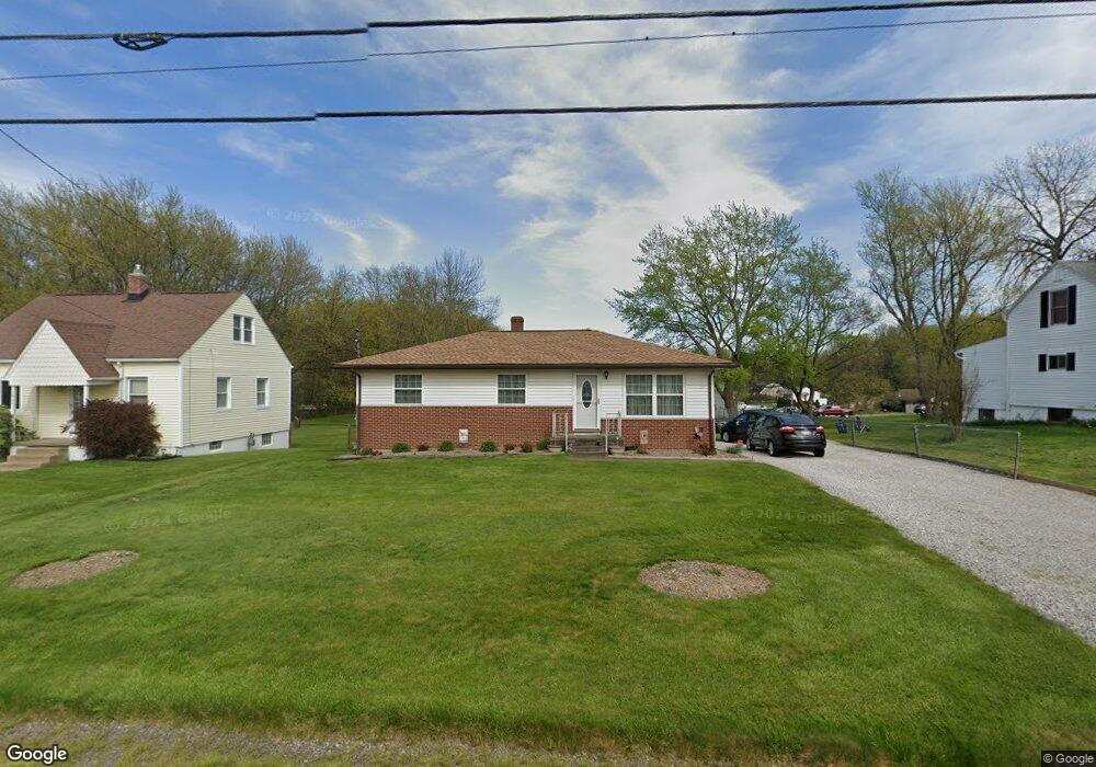
This home is located at 229 Columbine Ave, Akron, OH 44312 and is currently estimated at $146,287, approximately $133 per square foot. 229 Columbine Ave is a home located in Summit County with nearby schools including Springfield High School, Summit Academy Akron Elementary School, and Hatton Community Learning Center.
Ownership History
Date
Name
Owned For
Owner Type
Purchase Details
Closed on
Aug 17, 1998
Sold by
Est Martha M Taylor
Bought by
Cogar Kenneth R
Current Estimated Value
Home Financials for this Owner
Home Financials are based on the most recent Mortgage that was taken out on this home.
Original Mortgage
$59,900
Outstanding Balance
$12,660
Interest Rate
7.07%
Mortgage Type
New Conventional
Estimated Equity
$133,627
Create a Home Valuation Report for This Property
The Home Valuation Report is an in-depth analysis detailing your home's value as well as a comparison with similar homes in the area
Home Values in the Area
Average Home Value in this Area
Purchase History
| Date | Buyer | Sale Price | Title Company |
|---|---|---|---|
| Cogar Kenneth R | $79,900 | -- |
Source: Public Records
Mortgage History
| Date | Status | Borrower | Loan Amount |
|---|---|---|---|
| Open | Cogar Kenneth R | $59,900 |
Source: Public Records
Tax History Compared to Growth
Tax History
| Year | Tax Paid | Tax Assessment Tax Assessment Total Assessment is a certain percentage of the fair market value that is determined by local assessors to be the total taxable value of land and additions on the property. | Land | Improvement |
|---|---|---|---|---|
| 2025 | $1,891 | $33,208 | $7,889 | $25,319 |
| 2024 | $1,891 | $33,208 | $7,889 | $25,319 |
| 2023 | $1,891 | $33,208 | $7,889 | $25,319 |
| 2021 | $1,785 | $29,131 | $6,920 | $22,211 |
| 2020 | $1,845 | $29,130 | $6,920 | $22,210 |
| 2019 | $1,699 | $24,810 | $7,070 | $17,740 |
| 2018 | $1,634 | $24,810 | $7,070 | $17,740 |
| 2017 | $1,698 | $24,810 | $7,070 | $17,740 |
| 2016 | $1,714 | $24,810 | $7,070 | $17,740 |
| 2015 | $1,698 | $24,810 | $7,070 | $17,740 |
| 2014 | $1,678 | $24,810 | $7,070 | $17,740 |
| 2013 | $1,803 | $26,600 | $7,070 | $19,530 |
Source: Public Records
Map
Nearby Homes
- 0 Kreiner Ave
- 2948 Trenton Rd
- 379 Stull Ave
- 117 Kreiner Ave
- 307 Pauline Ave
- V/L Marion Ave
- 47 Kreiner Ave
- 233 Marion Ave
- 366 Dennison Ave
- 48 Marion Ave
- 6 Kreiner Ave
- 5 Kreiner Ave
- 544 Dennison Ave
- 3472 Curtis St
- 490 Stevenson Ave
- 412 Stevenson Ave
- 256 High Grove Blvd
- 2863 Burnside St
- 3394 Albrecht Ave
- 440 Wirth Ave
- 219 Columbine Ave
- 233 Columbine Ave
- 218 Columbine Ave
- 222 Columbine Ave
- 214 Columbine Ave
- 211 Columbine Ave
- 2943 Pepper Hill Cir
- 251 Columbine Ave
- 2985 Pepperhill Rd
- 246 Columbine Ave
- 2970 Pepperhill Rd
- 206 Columbine Ave
- 212 Columbine Ave
- 201 Columbine Ave
- S/L 5 Pepper Hill Cir
- S/L 6&7 Pepper Hill Cir
- S/L 8&9 Pepper Hill Cir
- 2935 Pepper Hill Cir
- 2993 Pepperhill Rd
- 257 Columbine Ave