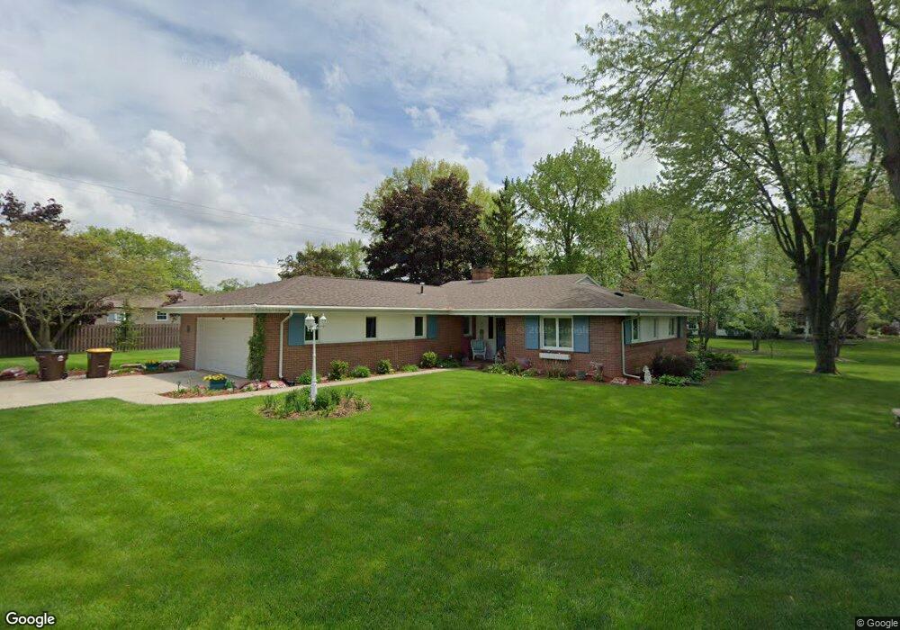
229 Kettenring Dr Defiance, OH 43512
Estimated Value: $234,922 - $271,000
2
Beds
2
Baths
1,662
Sq Ft
$152/Sq Ft
Est. Value
About This Home
This home is located at 229 Kettenring Dr, Defiance, OH 43512 and is currently estimated at $252,231, approximately $151 per square foot. 229 Kettenring Dr is a home located in Defiance County with nearby schools including Defiance Elementary School, Defiance Middle School, and Defiance High School.
Ownership History
Date
Name
Owned For
Owner Type
Purchase Details
Closed on
Mar 7, 2007
Sold by
Dougal Richard Irving and Dougal Ocie Carol
Bought by
Dougal Richard Irving and Dougal Ocie Carol
Current Estimated Value
Purchase Details
Closed on
Apr 12, 2002
Bought by
Dougal Richard Irving and Ocie Carol
Purchase Details
Closed on
Mar 5, 1996
Bought by
Dougal Richard Irving and Ocie Carol
Create a Home Valuation Report for This Property
The Home Valuation Report is an in-depth analysis detailing your home's value as well as a comparison with similar homes in the area
Home Values in the Area
Average Home Value in this Area
Purchase History
| Date | Buyer | Sale Price | Title Company |
|---|---|---|---|
| Dougal Richard Irving | -- | -- | |
| Dougal Richard Irving | $112,000 | -- | |
| Dougal Richard Irving | -- | -- |
Source: Public Records
Tax History Compared to Growth
Tax History
| Year | Tax Paid | Tax Assessment Tax Assessment Total Assessment is a certain percentage of the fair market value that is determined by local assessors to be the total taxable value of land and additions on the property. | Land | Improvement |
|---|---|---|---|---|
| 2024 | $2,338 | $72,050 | $9,280 | $62,770 |
| 2023 | $2,338 | $72,050 | $9,280 | $62,770 |
| 2022 | $2,279 | $62,970 | $9,280 | $53,690 |
| 2021 | $2,279 | $62,970 | $9,280 | $53,690 |
| 2020 | $2,297 | $62,970 | $9,280 | $53,690 |
| 2019 | $2,097 | $57,160 | $9,280 | $47,880 |
| 2018 | $2,040 | $57,160 | $9,280 | $47,880 |
| 2017 | $1,918 | $57,158 | $9,278 | $47,880 |
| 2016 | $1,863 | $52,328 | $9,131 | $43,197 |
| 2015 | $896 | $52,234 | $9,131 | $43,103 |
| 2014 | $896 | $52,234 | $9,131 | $43,103 |
| 2013 | $896 | $52,234 | $9,131 | $43,103 |
| 2012 | $896 | $52,235 | $9,132 | $43,103 |
Source: Public Records
Map
Nearby Homes
- 700 North St
- 230 Adams St
- 734 E Front St
- 655 Burning Tree Dr
- 649 Burning Tree Dr
- 673 Burning Tree Dr
- 679 Burning Tree Dr
- 1408 Heatherdowns Dr
- 1365 Heatherdowns Dr
- 202 Southworth St
- 1819 Maumee Dr
- 1613 E 2nd St
- 1275 Pinehurst Dr
- 600 Tiedeman Ave
- 600 Euclid St
- 1702 E Hopkins St
- 1459 Deerwood Dr
- 319 East St
- 846 Deerwood Dr
- 850 Deerwood Dr
- 216 Carpenter Rd
- 225 Kettenring Dr
- 212 Carpenter Rd
- 300 Carpenter Rd
- 236 Kettenring Dr
- 240 Kettenring Dr
- 244 Kettenring Dr
- 217 Kettenring Dr
- 232 Kettenring Dr
- 208 Carpenter Rd
- 304 Carpenter Rd
- 209 Kettenring Dr
- 224 Kettenring Dr
- 204 Carpenter Rd
- 216 Kettenring Dr
- 220 Kettenring Dr
- 205 Kettenring Dr
- 200 Carpenter Rd
- 212 Kettenring Dr
- 305 Maywinn Dr