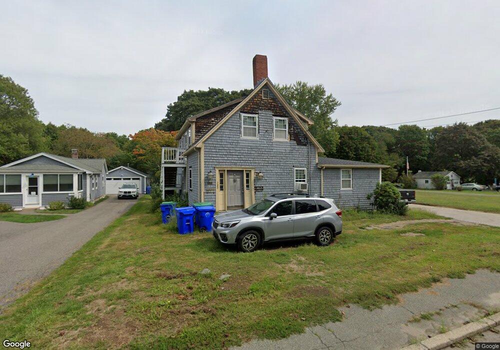
229 Liberty St Rockland, MA 02370
Estimated Value: $624,000 - $719,000
4
Beds
2
Baths
2,400
Sq Ft
$277/Sq Ft
Est. Value
About This Home
This home is located at 229 Liberty St, Rockland, MA 02370 and is currently estimated at $664,543, approximately $276 per square foot. 229 Liberty St is a home located in Plymouth County with nearby schools including Rockland Senior High School, Calvary Chapel Academy, and Holy Family Elementary School.
Ownership History
Date
Name
Owned For
Owner Type
Purchase Details
Closed on
Mar 12, 2010
Sold by
Tuffo Thomas F Est
Bought by
Pepgjonaj Sandra
Current Estimated Value
Home Financials for this Owner
Home Financials are based on the most recent Mortgage that was taken out on this home.
Original Mortgage
$250,381
Interest Rate
5.02%
Mortgage Type
Purchase Money Mortgage
Purchase Details
Closed on
Jun 25, 2003
Sold by
Jus 1 Jordan Rt
Bought by
Tuffo Thomas
Home Financials for this Owner
Home Financials are based on the most recent Mortgage that was taken out on this home.
Original Mortgage
$197,400
Interest Rate
5.53%
Mortgage Type
Purchase Money Mortgage
Purchase Details
Closed on
Oct 28, 2002
Sold by
Roman Catholic Archbis
Bought by
Raimondi Mark W and Tuffo Thomas F
Purchase Details
Closed on
Mar 21, 2002
Sold by
Ingram John P
Bought by
Tuffo Thomas
Create a Home Valuation Report for This Property
The Home Valuation Report is an in-depth analysis detailing your home's value as well as a comparison with similar homes in the area
Home Values in the Area
Average Home Value in this Area
Purchase History
| Date | Buyer | Sale Price | Title Company |
|---|---|---|---|
| Pepgjonaj Sandra | $255,000 | -- | |
| Tuffo Thomas | -- | -- | |
| Raimondi Mark W | $795,000 | -- | |
| Tuffo Thomas | $250,000 | -- |
Source: Public Records
Mortgage History
| Date | Status | Borrower | Loan Amount |
|---|---|---|---|
| Open | Tuffo Thomas | $246,137 | |
| Closed | Pepgjonaj Sandra | $250,381 | |
| Previous Owner | Tuffo Thomas | $247,000 | |
| Previous Owner | Tuffo Thomas | $197,400 |
Source: Public Records
Tax History Compared to Growth
Tax History
| Year | Tax Paid | Tax Assessment Tax Assessment Total Assessment is a certain percentage of the fair market value that is determined by local assessors to be the total taxable value of land and additions on the property. | Land | Improvement |
|---|---|---|---|---|
| 2025 | $7,642 | $559,000 | $230,300 | $328,700 |
| 2024 | $7,417 | $527,500 | $217,200 | $310,300 |
| 2023 | $6,988 | $459,100 | $188,800 | $270,300 |
| 2022 | $6,693 | $399,600 | $164,100 | $235,500 |
| 2021 | $6,121 | $354,200 | $149,200 | $205,000 |
| 2020 | $5,906 | $337,500 | $142,100 | $195,400 |
| 2019 | $5,555 | $310,000 | $135,400 | $174,600 |
| 2018 | $5,300 | $290,900 | $135,400 | $155,500 |
| 2017 | $5,121 | $277,100 | $135,400 | $141,700 |
| 2016 | $4,931 | $266,700 | $130,200 | $136,500 |
| 2015 | $4,908 | $257,900 | $121,700 | $136,200 |
| 2014 | $4,480 | $244,300 | $119,300 | $125,000 |
Source: Public Records
Map
Nearby Homes
- 92 Liberty St
- 49 Liberty St
- 133 Crescent St
- 94-96 Crescent St
- 63 Webster St
- 440 Market St
- 45-47 Park St
- 436 E Water St
- 354 Webster St
- 507 Liberty St
- 50 Linden Park
- 122 Reed St
- 38 Levin Rd
- 100 North Ave
- 140 W Water St
- 103 Grove St Unit 337
- 13 Dyer St Unit 13
- 11 Dyer St Unit 11
- 149 Concord St
- 14 Dyer St Unit 14
- 233 Liberty St
- 219 Liberty St
- 239 Liberty St
- 234 Liberty St
- 224 Liberty St
- 209 Liberty St
- 240 Liberty St
- 220 Liberty St
- 247 Liberty St
- 244 Liberty St
- 206 Liberty St
- 199 Liberty St
- 225 E Water St
- 219 E Water St
- 261 Liberty St
- 84 Custer St
- 211 E Water St
- 191 Liberty St
- 201 E Water St
- 192 Liberty St Unit 194