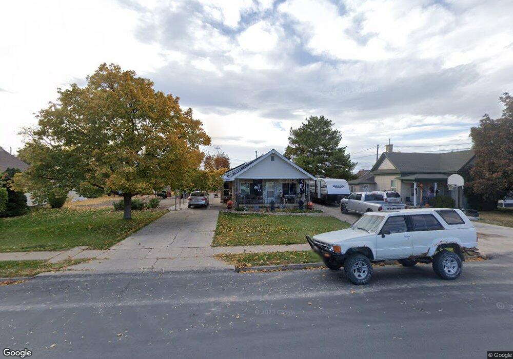
229 N 200 W Spanish Fork, UT 84660
Estimated Value: $363,000 - $419,000
2
Beds
1
Bath
1,108
Sq Ft
$350/Sq Ft
Est. Value
About This Home
This home is located at 229 N 200 W, Spanish Fork, UT 84660 and is currently estimated at $388,335, approximately $350 per square foot. 229 N 200 W is a home located in Utah County with nearby schools including Brockbank Elementary School, Spanish Fork Jr High School, and Spanish Fork High School.
Ownership History
Date
Name
Owned For
Owner Type
Purchase Details
Closed on
Nov 21, 2022
Sold by
Moleff Joseph M
Bought by
Moleff Janette
Current Estimated Value
Purchase Details
Closed on
Nov 24, 2018
Sold by
Moleff Theodore and Moleff Sonja M
Bought by
Moleff Janette and Moleff Matthew I
Purchase Details
Closed on
Oct 7, 2008
Sold by
Moleff Andrew and Moleff Janette
Bought by
Moleff Theodore and Moleff Sonja M
Purchase Details
Closed on
Apr 4, 2005
Sold by
Moleff Janette
Bought by
Moleff Andrew and Moleff Janette
Home Financials for this Owner
Home Financials are based on the most recent Mortgage that was taken out on this home.
Original Mortgage
$100,000
Interest Rate
6.37%
Mortgage Type
New Conventional
Purchase Details
Closed on
Jun 21, 2002
Sold by
Poulsen Blaine A and Poulsen Glen M
Bought by
Moleff Janette
Home Financials for this Owner
Home Financials are based on the most recent Mortgage that was taken out on this home.
Original Mortgage
$95,900
Interest Rate
6.74%
Create a Home Valuation Report for This Property
The Home Valuation Report is an in-depth analysis detailing your home's value as well as a comparison with similar homes in the area
Home Values in the Area
Average Home Value in this Area
Purchase History
| Date | Buyer | Sale Price | Title Company |
|---|---|---|---|
| Moleff Janette | -- | -- | |
| Moleff Janette | -- | None Available | |
| Moleff Theodore | -- | Accommodation | |
| Moleff Andrew | -- | Equity Title | |
| Moleff Janette | -- | Horizon Title Insurance Agen |
Source: Public Records
Mortgage History
| Date | Status | Borrower | Loan Amount |
|---|---|---|---|
| Previous Owner | Moleff Andrew | $100,000 | |
| Previous Owner | Moleff Janette | $95,900 |
Source: Public Records
Tax History Compared to Growth
Tax History
| Year | Tax Paid | Tax Assessment Tax Assessment Total Assessment is a certain percentage of the fair market value that is determined by local assessors to be the total taxable value of land and additions on the property. | Land | Improvement |
|---|---|---|---|---|
| 2025 | $1,543 | $179,300 | $161,500 | $164,500 |
| 2024 | $1,543 | $159,005 | $0 | $0 |
| 2023 | $1,516 | $156,475 | $0 | $0 |
| 2022 | $1,746 | $176,660 | $0 | $0 |
| 2021 | $1,447 | $234,200 | $93,700 | $140,500 |
| 2020 | $1,300 | $204,700 | $78,100 | $126,600 |
| 2019 | $1,136 | $188,200 | $78,100 | $110,100 |
| 2018 | $1,086 | $173,800 | $78,100 | $95,700 |
| 2017 | $952 | $81,950 | $0 | $0 |
| 2016 | $822 | $69,795 | $0 | $0 |
| 2015 | $761 | $63,800 | $0 | $0 |
| 2014 | $773 | $65,120 | $0 | $0 |
Source: Public Records
Map
Nearby Homes