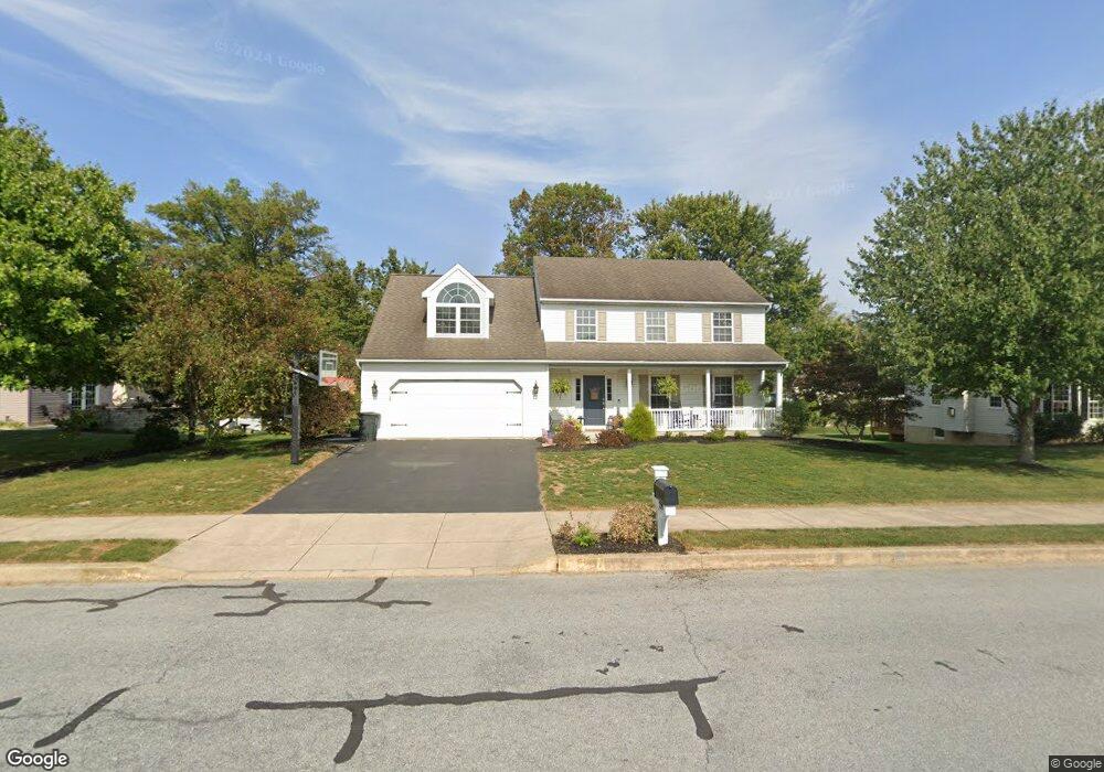
229 N Point Dr Manheim, PA 17545
Estimated Value: $479,827 - $529,000
4
Beds
3
Baths
2,345
Sq Ft
$215/Sq Ft
Est. Value
About This Home
This home is located at 229 N Point Dr, Manheim, PA 17545 and is currently estimated at $505,207, approximately $215 per square foot. 229 N Point Dr is a home located in Lancaster County with nearby schools including Manheim Central Senior High School, Manheim Christian Day School, and Sporting Hill Christian School.
Ownership History
Date
Name
Owned For
Owner Type
Purchase Details
Closed on
Jul 30, 2010
Sold by
Ashcraft David N and Ashcraft Ruth E
Bought by
Simmons Michael and Simmons Amy
Current Estimated Value
Home Financials for this Owner
Home Financials are based on the most recent Mortgage that was taken out on this home.
Original Mortgage
$220,000
Outstanding Balance
$146,832
Interest Rate
4.73%
Mortgage Type
New Conventional
Estimated Equity
$358,375
Create a Home Valuation Report for This Property
The Home Valuation Report is an in-depth analysis detailing your home's value as well as a comparison with similar homes in the area
Home Values in the Area
Average Home Value in this Area
Purchase History
| Date | Buyer | Sale Price | Title Company |
|---|---|---|---|
| Simmons Michael | $275,000 | None Available |
Source: Public Records
Mortgage History
| Date | Status | Borrower | Loan Amount |
|---|---|---|---|
| Open | Simmons Michael | $220,000 |
Source: Public Records
Tax History Compared to Growth
Tax History
| Year | Tax Paid | Tax Assessment Tax Assessment Total Assessment is a certain percentage of the fair market value that is determined by local assessors to be the total taxable value of land and additions on the property. | Land | Improvement |
|---|---|---|---|---|
| 2025 | $6,310 | $261,900 | $57,100 | $204,800 |
| 2024 | $6,310 | $261,900 | $57,100 | $204,800 |
| 2023 | $6,198 | $261,900 | $57,100 | $204,800 |
| 2022 | $5,998 | $261,900 | $57,100 | $204,800 |
| 2021 | $5,817 | $261,900 | $57,100 | $204,800 |
| 2020 | $5,817 | $261,900 | $57,100 | $204,800 |
| 2019 | $5,731 | $261,900 | $57,100 | $204,800 |
| 2018 | $3,637 | $261,900 | $57,100 | $204,800 |
| 2017 | $5,220 | $190,800 | $43,300 | $147,500 |
| 2016 | $5,067 | $190,800 | $43,300 | $147,500 |
| 2015 | $1,676 | $190,800 | $43,300 | $147,500 |
| 2014 | $3,158 | $190,800 | $43,300 | $147,500 |
Source: Public Records
Map
Nearby Homes
- 188 N Main St
- 162 N Charlotte St
- 239 E High St
- 2 S Charlotte St
- 609 Hamaker Rd
- 108 110 S Main St
- 27 W Ferdinand St
- 55 S Grant St
- 121 Mill St
- 33 W Ferdinand St
- 37 W Ferdinand St
- 123 S Main St
- 125 S Main St
- 43 W Ferdinand St
- 218 W Ferdinand St
- 113 S Grant St
- 140 S Charlotte St
- 554 Mallard Dr
- 51 S Snyder St
- 655 White Oak Rd
- 225 N Point Dr
- 133 Hamaker Rd
- 236 N Laurel St
- 230 N Laurel St
- 0 Linden Design Unit 1004730273
- 0 Linden Design Unit 1004725849
- 0 Linden Design Unit 1004612573
- 0 Linden Design Unit 1004606541
- 0 Linden Design Unit 1004558903
- 0 Linden Design Unit 1002802625
- 0 Linden Design Unit 134452
- 0 Linden Design Unit 142612
- 0 Linden Design Unit 145622
- 0 Linden Design Unit 163276
- 0 Linden Design Unit 172662
- 0 Linden Design Unit 188281
- 0 Linden Design Unit 196344
- 0 Linden Design Unit 222942
- 0 Linden Design Unit 238835
- 0 Linden Design Unit PALA146448